With more oil moving through Washington by train and other transportation modes, state lawmakers want oil companies to keep environmental regulators better informed. | credit: Katie Campbell | rollover image for more
SEATTLE — Washington lawmakers took up a proposal Wednesday to require more transparency from companies that transport oil through the state.
The hearing on House Bill 2347 played out before a packed committee room in Olympia. The new bill would require oil companies to file weekly reports with the state Department of Ecology detailing how much oil is being transported, what kind of oil it is, how it’s being moved and what route it’s traveling through the state.
Right now oil companies aren’t required to share any specific information with state agencies about how much oil is traveling the railways.
Johan Hellman of BNSF Railway says it should stay that way. BNSF is the company currently delivering oil from the Bakken oil fields of North Dakota to Washington refineries. That traffic could increase as rail-to-ship transfer terminals are being proposed for ports on the Columbia River and Puget Sound.
Hellman said increased transparency brings greater security risks.
“You can imagine if you’re publicizing information about specific routes, specific volumes, locations where those are being shipped it does provide a tremendous security concern,” he said in his testimony, adding that the oil companies don’t want to share that information for competitive purposes.
The U.S. Department of Transportation has classified Bakken oil as a hazardous material because it catches fire and explodes at much lower temperatures than previously thought.
Several city and county officials voiced support for the bill and concerns over the uptick in oil-by-rail traffic.
“I think we’re taking bombs through our cities when you look at Spokane,” said Ben Stuckart, president of the Spokane city council. “We’re in a situation where our town would be split in half if we look at a derailment.”
Oil trains currently run through Spokane before following the Columbia River. Once in Western Washington, they head north through the Interstate 5 corridor, passing through other towns and cities along their route.
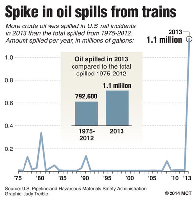
More oil was spilled from trains in 2013 than in the last four decades combined. That’s according to an analysis of federal data by McClatchyDC.
The bill could be amended before passing out of committee. No Republicans have signed on to support the bill.
SEATTLE — Months after Washington voters narrowly rejected an initiative requiring labeling of genetically modified foods, lawmakers are reviving the GMO debate in Olympia.
One bill would require labeling genetically engineered salmon for sale, even though federal regulators have not yet approved any genetically modified animals for food. Another bill requires many foods containing GMOs to carry a label.
The debate comes as the U.S. Department of Agriculture is considering approval of an apple engineered not to brown. The U.S. Food and Drug Administration is also weighing an application for a genetically modified salmon that grows twice as fast as normal.
In Olympia, a public hearing is scheduled Friday in the House Committee on Agriculture & Natural Resources on the bill. That measure also would prohibit genetically engineered finfish from being produced in state waters
WASHINGTON — More crude oil was spilled in U.S. rail incidents last year than was spilled in the nearly four decades since the federal government began collecting data on such spills, an analysis of the data shows.
Including major derailments in Alabama and North Dakota, more than 1.15 million gallons of crude oil was spilled from rail cars in 2013, according to data from the Pipeline and Hazardous Materials Safety Administration.
By comparison, from 1975 to 2012, U.S. railroads spilled a combined 800,000 gallons of crude oil. The spike underscores new concerns about the safety of such shipments as rail has become the preferred mode for oil producers amid a North American energy boom.
The federal data does not include incidents in Canada where oil spilled from trains. Canadian authorities estimate that more than 1.5 million gallons of crude oil spilled in Lac-Megantic, Quebec, on July 6, when a runaway train derailed and exploded, killing 47 people. The cargo originated in North Dakota.
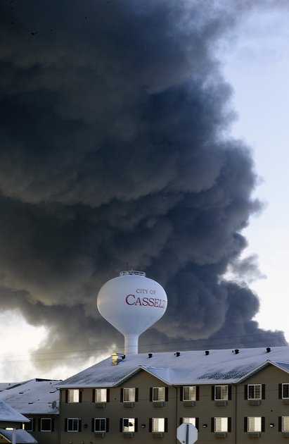
A fireball goes up at the site of an oil train derailment Monday, Dec 30, 2013, in Casselton, N.D. The train carrying crude oil derailed near Casselton Monday afternoon. BRUCE CRUMMY — ASSOCIATED PRESS
Nearly 750,000 gallons of crude oil spilled from a train on Nov. 8 near Aliceville, Ala. The train also originated in North Dakota and caught fire after it derailed in a swampy area. No one was injured or killed.
The Pipeline and Hazardous Materials Safety Administration doesn’t yet have spill data from a Dec. 30 derailment near Casselton, N.D. But the National Transportation Safety Board, which is the lead investigator in that incident, estimates that more than 400,000 gallons of crude oil were spilled there. Though no one was injured or killed, the intense fire forced most of Casselton’s 2,400 residents to evacuate in subzero temperatures.
The Association of American Railroads, an industry group, estimates that railroads shipped 400,000 carloads of crude oil last year. That’s more than 11.5 billion gallons, with one tank car holding roughly 28,800 gallons.
Last year’s total spills of 1.15 million gallons means that 99.99 percent of shipments arrived without incident, close to the safety record the industry and its regulators claim about hazardous materials shipments by rail.
But until just a few years ago, railroads weren’t carrying crude oil in 80- to 100-car trains. In eight of the years between 1975 and 2009, railroads reported no spills of crude oil. In five of those years, they reported spills of one gallon or less.
In 2010, railroads reported spilling about 5,000 gallons of crude oil, according to federal data. They spilled fewer than 4,000 gallons each year in 2011 and 2012. But excluding the Alabama and North Dakota derailments, more than 11,000 gallons of crude oil spilled from trains last year.
Last week, the principal Washington regulators of crude oil shipments by rail met with railroad and oil industry representatives to discuss making changes to how crude is shipped by rail, from tank car design to operating speed to appropriate routing. Transportation Secretary Anthony Foxx called the meeting productive and said the group would take a comprehensive approach to improving the safety of crude-oil trains.
Foxx said the changes would be announced within the next 30 days.
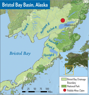
JUNEAU — U.S. Sen. Mark Begich has come out against the proposed Pebble Mine, calling the massive gold-and-copper project “the wrong mine in the wrong place for Alaska.”
In a statement released by his office Monday, Begich said he has long supported Alaska’s mining industry and believes continued efforts must be made to support resource-development industries that help keep Alaska’s economy strong. But he said “years of scientific study (have) proven the proposed Pebble Mine cannot be developed safely in the Bristol Bay watershed.”
“Thousands of Alaskans have weighed in on this issue, and I have listened to their concerns,” he said. “Pebble is not worth the risk.”
In 2011, the U.S. Environmental Protection Agency initiated a review of large-scale mining in the Bristol Bay region in response to concerns about the impact of the proposed Pebble Mine on fisheries. The agency released its final report last week, concluding that large-scale mining in the Bristol Bay watershed posed significant risks to salmon and Alaska Native cultures that rely on it. The region is home to a world-premier sockeye salmon fishery.
The Bristol Bay basin is made up of six major watersheds: the Togiak, Nushagak, Kvichak, Naknek, Egegik, and Ugashik. Image source: Wild Salmon Center.org
The report did not recommend any policy or regulatory decisions. But EPA regional administrator Dennis McLerran said it would serve as the scientific foundation for the agency’s response to the tribes and others who petitioned EPA to use its authority under the Clean Water Act to protect Bristol Bay. Mine opponents have been pressing the agency to take steps to block or limit the project.
Begich, a Democrat, is the only member of the state’s congressional delegation to outright oppose the project, and his position, first reported by the Anchorage Daily News, won praise from Pebble critics on Monday.
Sen. Lisa Murkowski and Rep. Don Young, both Republicans, last week expressed concerns that the EPA report could be used to pre-emptively veto the project, saying that would set a bad precedent.
“If the EPA has concerns about the impact of a project there is an appropriate time to raise them – after a permit application has been made, not before,” Murkowski said in a release.
Under section 404c of the Clean Water Act, the EPA has the authority to restrict, prohibit, deny or withdraw use of an area as a disposal site for dredged or fill material if the discharge would have “unacceptable adverse” effects on things like municipal water supplies or fisheries, according to an EPA fact sheet. The agency says it has issued just over a dozen final veto actions since 1972.
Mike Heatwole, a spokesman for the Pebble Limited Partnership, the group behind the project, said Pebble is disappointed that Begich had “come out against thousands of new jobs, hundreds of millions in state revenue, and potentially billions in economic activity for Alaska.”
Heatwole said in a statement that it is “no secret that there is a substantial difference of opinion regarding the science of EPA’s recent Bristol Bay Assessment. Not many Alaskans think EPA is impartial.”
He said there is a process that exists for evaluating a project, and there is no environmental harm in allowing Pebble to follow that permitting process.
Begich told The Associated Press that one of the complaints he hears from the mining industry is that it needs to know what federal agencies want before getting too far along in the permitting process. He said if Pebble intends to apply for a permit, the watershed assessment provides a framework for what to respond to before the permit process starts.
The federal government today released its final plan to protect endangered salmon and steelhead in the Columbia River Basin. | credit: Aaron Kunz | rollover image for more
The federal government is standing by its previous plans for managing the Columbia River to prevent the extinction of its salmon and steelhead. That means little would change for dam operations on the West’s biggest river — but only if it wins court approval.
Officials Friday released the finalized plan, known as the biological opinion or BiOp. It guides dam operations to assure they do not lead to the extinction of 13 species of salmon and steelhead that are protected under the Endangered Species Act. The plan has been the subject of more than 20 years of legal conflict between people who want to protect salmon and people who want the dams to produce hydroelectricity and maintain shipping traditions.
The National Oceanic and Atmospheric Administration is the lead agency in developing the biological opinion. It says the current plan is on track to meet Endangered Species Act goals for the federally protected fish. NOAA officials say the plan may better protect some fish than previously thought.
“The actions outlined in the biological opinion, and the operation of the hydro system, is designed to move us in the direction towards recovery and avoid jeopardy, and this program does that,” said NOAA’s Barry Thom. “It actually does improve the status of the populations over time. But it is not designed to achieve ultimate recovery of the population.”
Officials say the 610-page plan will protect and improve habitat, with specific attention paid to tributaries and estuaries of the Columbia and Snake rivers.
“A major focus of the tributary habitat program is to help us buffer against potential effects of climate change in the system, so that the habitat projects … are designed to maintain and protect the cool water inputs into the system,” Thom said during a conference call with reporters.
NOAA released a draft version of this plan in September.
In 2011, U.S. District Judge James A. Redden rejected the plan and asked the Obama administration to consider more ways to recover the endangered fish.
Redden’s suggestions included spilling more water over the dams to help juvenile salmon safely make it downriver to the ocean, changing reservoirs to help fish passage, and removing the Snake River dams altogether.
The case has been transferred to Judge Michael H. Simon. He has yet to set a court date for the plan’s sponsors and opponents to argue it. He’ll then decide if the plan is adequate to protect Columbia River salmon and steelhead.
Now that the previous version of the plan is partway completed, supporters say a trend toward larger salmon runs shows the plan is working. Terry Flores is with Northwest RiverPartners, which represents commerce and industry groups that defend the presence of hydroelectric dams on the Columbia-Snake system.
“This plan is amazing. It’s the most comprehensive plan we can find anywhere in this country by far,” Flores said.
Environmental groups say they are disappointed with this finalized plan. Gilly Lyons, with advocacy group Save Our Wild Salmon, said the group is frustrated.
“The federal agencies in charge here have re-isuued a slightly tweaked, but largely status quo federal salmon plan that repeats a lot of the same mistakes over the past decade or so that kept them in court and bound them in litigation over these dams and the salmon that they impact,” Lyons said.
Lyons said it is too soon to tell if environmental groups will file another lawsuit.
“With all the stuff that we see in the plan, or that’s not there, as the case may be, it sure looks like the federal government would like to go back to court,” Lyons said.
NOAA officials said there will be a few years before they have to start writing a new 10-year plan beyond 2018.
“One main priority is to carry out this existing biological opinion,” Thom said. “There will be a period of time between [the 2018 discussions] and the next couple of years where I would like to focus our efforts on talking about long-term recovery. … As opposed to focusing either on A) the litigation or B) the details of a new biological opinion beyond 2018.”
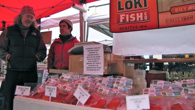
Pete Knutson and his son, Dylan, sell their wild-caught salmon at farmer’s markets around Seattle. “We had people passing on our fish this year. It was directly because they were worried about Fukushima.” | credit: Ashley Ahearn
SEATTLE — Japan’s nuclear disaster released hundreds of millions of gallons of radioactive water in 2011, sparking rampant speculation that a contaminated plume would reach the waters of North America’s West Coast.
Three years later, such speculation is alive and well on the Internet. Consider this video shot at a beach in Northern California and posted last month to YouTube:
“This is one of the problems,” says Kim Martini, a physical oceanographer at the University of Washington who has been following the issue closely. A Geiger counter can tell you if there’s radiation present, she said, “but it can’t differentiate between different kinds of radiation.”
California state officials went back and tested the beach and found the radiation to be naturally occurring in the rock formations there.
Martini and other scientists have received hate mail for trying to dispel some of the online fears about radioactive pollution resulting from the meltdown of Japan’s Fukushima Daichi Nuclear Power Station. It was triggered by the Tohoku earthquake and tsunami, which struck Japan in March, 2011.
“There’s definitely people that you’re never going to convince… I don’t know what to tell you. The science says it’s OK,” Martini said.
Scientists in California and Oregon have collected samples of tuna, a fish known to migrate back and forth across the Pacific, and analyzed them for radioactive isotopes, Cesium-134 in particular, from Fukushima.
Delvan Neville, a PhD candidate in Radiation Health Physics at Oregon State University, has tested dozens of samples of albacore tuna for radioactivity. The U.S. Food and Drug Administration’s intervention levels for cesium 134 and cesium 137 is 1200 becquerels per kilogram. The highest levels he’s seen in his albacore, of both cesium 134 and cesium 137 combined, is 1 becquerel per kilogram – a level so low that his device couldn’t pick it up until he concentrated the samples.
“That’s more than 1,000 times lower than the point where the FDA would even think about whether they need to let people eat that food still,” he said.
Neville joked that he was eating the tuna he caught right alongside the samples he collected for science, “which was actually kind of fun because then I was telling people as we were eating at the table what their approximate dose was due to Fukushima from the food they were eating and it’s this ridiculously small number.”
There is radioactive material from Fukushima making its way across the Pacific Ocean and it has already reached the West Coast in small amounts. The largest concentration of radioactive water released during the nuclear meltdown is moving in a plume across the middle of the Pacific, but models project that the majority of the radioactive water will sink or be pushed west again before it hits the U.S. Scientists are still debating how high those radioactivity levels could be. Here’s an interesting video on ocean currents and Fukushima radioactivity:
Kim Martini says here on the West Coast, scientists have found very low levels of cesium from Fukushima:
“It’s about 20,000 times less than drinking water standards. And so what we like to say is it’s detectable but harmless.”
But despite all the evidence, some fish consumers on the West Coast have been wary.
Pete Knutson has been fishing for salmon in Alaska for more than 40 years. He owns and operates Loki Fish Company with his two sons. On the weekends you’ll find him selling his fish at farmer’s markets around Seattle, with white hair flowing out from under a knit cap and an easy laugh that draws passersby up to his stall.
“We have all different kinds of salmon products, pickled salmon, ikura, smoked salmon, canned salmon, whole pink salmon over there,” he gestures to rows of neatly packaged pink salmon meat.
Knutson’s in the business of catching fish, not testing them. But after the Fukushima meltdown his customers wanted answers about the safety of his product.
So he sent seven salmon samples off to an internationally certified lab to test for radioactive isotopes. Five of the seven samples came back without any detectable levels of radioactive isotopes from Fukushima, Knutson said, and two showed levels several hundred times below approved levels.
The tests cost Knutson $1,200 but he says it was a necessary investment.
“People do not trust governmental authorities. They don’t trust corporations. They don’t trust explanations and they don’t have a good science background,” Knutson said. “So it makes for a good combination where rumors can start spreading like wildfire, rumors like the whole pacific is poisoned, rumors like starfish, salmon seals, they’re all poisoned from the radiation and it’s not true. This is not definitive proof that there’s not a problem but it’s an indicator.”
Fisheries in Japan remain closed because of high levels of radioactivity and the ongoing release of contaminated groundwater from the nuclear site, but the FDA, Washington Department of Health, Woods Hole Oceanographic Institute and others have stressed that levels of radioactivity in fish that have made their way across the Pacific are not at levels of concern.
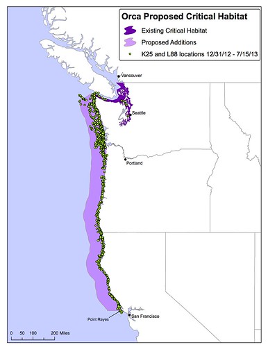
An environmental group is calling for a major expansion in habitat protection for Puget Sound’s killer whales.
Research shows the endangered orcas that live in Puget Sound in the summer are venturing up and down the West Coast in the winter to forage for food. Scientists tracking these southern resident orcas have followed the whales as far north as Alaska and as far south as Monterey, Calif.
Given these findings, the Center for Biological Diversity says the whales need a lot more habitat protection than they have now. The group filed a petition Thursday with the National Marine Fisheries Service to expand protected habitat for the whales from Puget Sound to a large swath of ocean area off the coasts of Washington, Oregon and Northern California.
“They need to protect all of their habitat — not just where the whales hang out in the summer,” says Sarah Uhlemann of the Center for Biological Diversity.
Existing vs. proposed critical habitat.
Protected habitat for species listed under the Endangered Species Act, known as “critical habitat,” comes with restrictions on actions taken by the federal government that might threaten the species’ survival.
Uhlemann says those restrictions would apply to federal decisions on salmon fishing, port expansions and other coastal developments. That would mean any time the federal government decides to do anything -– say the Navy decides to practice some sonar or an agency is deciding whether to permit a port expansion — the government would have to fully consider environmental impacts.
“Not only on the whale but also on its habitat –- and if the impacts are too large they have to stop and mitigate, or lessen what those impacts are,” Uhlemann said.
Lynne Barre is a marine biologist and manager in Seattle with the National Oceanic and Atmospheric Administration. She said the federal government was already considering an expansion in habitat protections for southern resident orcas as its tagging research program has revealed more about where the whales are feeding.
“Our knowledge of their habitat in the ocean is increasing,” Barre said. “Gathering additional information about their coastal habitat was one of the priorities we identified when we listed the orcas for protection under the Endangered Species Act in 2005.”
The orcas face threats from a lack of available food because they primarily survive on salmon, Barre said. They also accumulate high levels of contaminants such as flame retardants, legacy pesticides and industrial pollutants that can impact their immune systems. Orcas are acoustic animals that use sound to communicate with each other and find prey, she said, so underwater noises from vessels and other activities pose another threat to the whales.
The existing critical habitat protections in Puget Sound require evaluations of the impacts to whales from pollution discharges, ship passage and construction activities such as pile-driving, Barre said. Federal regulators will have 90 days to decide whether to review the Center for Biological Diversity’s petition to expand the area where those kinds of protections apply.
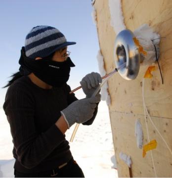
Scientists studying the atmosphere above Barrow, Alaska, have discovered unprecedented levels of molecular chlorine in the air, a new study reports.
Molecular chlorine, from sea salt released by melting sea ice, reacts with sunlight to produce chlorine atoms. These chlorine atoms are highly reactive and can oxidize many constituents of the atmosphere including methane and elemental mercury, as well activate bromine chemistry, which is an even stronger oxidant of elemental mercury. Oxidized mercury is more reactive and can be deposited to the Arctic ecosystem.
Jin Liao checks the instrumentation in Barrow, Alaska, during a research trip to measure molecular chlorine in the atmosphere. Image-Georgia Tech
The study is the first time that molecular chlorine has been measured in the Arctic, and the first time that scientists have documented such high levels of molecular chlorine in the atmosphere.
“No one expected there to be this level of chlorine in Barrow or in polar regions,” said Greg Huey, a professor in the School of Earth and Atmospheric Sciences at the Georgia Institute of Technology in Atlanta.
The study was published January 12 in the journal Nature Geoscience and was supported by the National Science Foundation (NSF), part of the international multidisciplinary OASIS program.
The researchers directly measured molecular chlorine levels in the Arctic in the spring of 2009 over a six-week period using chemical ionization mass spectrometry. At first the scientists were skeptical of their data, so they spent several years running other experiments to ensure their findings were accurate.
The level of molecular chlorine above Barrow was measured as high as 400 parts per trillion, which is a high concentration considering that chlorine atoms are short –lived in the atmosphere because they are strong oxidants and are highly reactive with other atmospheric chemicals.
Molecular chlorine concentrations peaked in the early morning and late afternoon, and fell to near-zero levels at night. Average daytime molecular chlorine levels were correlated with ozone concentrations, suggesting that sunlight and ozone may be required for molecular chlorine formation.
Previous Arctic studies have documented high levels of oxidized mercury in Barrow and other polar regions. The major source of elemental mercury in the Arctic regions is coal-burning plants around the world. In the spring in Barrow, ozone and elemental mercury are often depleted from the atmosphere when halogens — chlorine and bromine — are released into the air from melting sea ice.
“Molecular chlorine is so reactive that it’s going to have a very strong influence on atmospheric chemistry,” Huey said.
Chlorine atoms are the dominant oxidant in Barrow, the study found. The area is part of a region with otherwise low levels of oxidants in the atmosphere, due to the lack of water vapor and ozone, which are the major precursors to making oxidants in many urban areas.
In Barrow, snow-covered ice pack extends in every direction except inland. The ultimate source of the molecular chlorine is the sodium chloride in sea salt, Huey said, most likely from the snow-covered ice pack. How the sea salt is transformed into molecular chlorine is unknown.
“We don’t really know the mechanism. It’s a mystery to us right now,” Huey said. “But the sea ice is changing dramatically, so we’re in a time where we have absolutely no predictive power over what’s going to happen to this chemistry. We’re really in the dark about the chlorine.”
Scientists do know that sea ice is rapidly changing, Huey said. The sea ice that lasts from one winter to the next winter is decreasing. This has created a larger area of melted ice, and more ice that comes and goes with the seasons. This seasonal variation in ice could release more molecular chlorine into the atmosphere.
“There is definite climate change happening in the Arctic,” Huey said. “That’s changing the nature of the ice, changing the volume of the ice, changing the surface area and changing the chemistry of the ice.”
This research is supported by the National Science Foundation under award number ATM-0807702, ARC-0806437 and ARC-0732556. Any conclusions or opinions are those of the authors and do not necessarily represent the official views of the NSF.
Washington’s top environmental regulator found herself in the hot seat Thursday during a state Senate hearing called by Republican lawmakers who disapprove her agency’s scrutiny of a coal export terminal proposed for the northern shore of Puget Sound.
At issue: greenhouse gas emissions.
The Department of Ecology caused a stir last year when it announced that it would consider the greenhouse gas emissions produced when 48 million tons of exported coal is burned in Asia – that’s how much coal would move through the Gateway Pacific Terminal every year.
Sen. Doug Ericksen, R-Ferndale, convened a work session to question Ecology officials, including director Maia Bellon, about its move.
Ericksen emphasized fears among business and trade leaders that Ecology’s move sets a precedent.
Some worry that in the future the state could consider the greenhouse gas emissions of say, exporting Boeing airplanes or apples, and that could prevent projects from going forward.
Here’s an exchange between Bellon and Ericksen:
Maia Bellon
Bellon: Because there is no question about the end use of the commodity for the coal transportation projects, it makes that different in terms of the pollution that’s created.
Ericksen: I know we’re over time but I essentially heard you say that the Department of Ecology can pick and choose and no business can have a guarantee of what will be studied and what will not be studied.
Bellon said that greenhouse gases are a pollutant and therefore should be considered in the environmental review of projects.
But she stressed that her agency considers projects on a case-by-case basis and the environmental review is meant to present information. It’s not a final decision on whether a project is built or not.
The committee did not take any action during Thursday’s hearing.
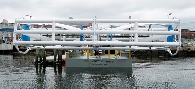
In this June 13, 2011 file photo, the Energy Tide 2, the largest tidal energy turbine ever deployed in the U.S., appears on a barge in Portland, Maine. Scientists at the University of Washington have determined that Admiralty Inlet, in Puget Sound, is an excellent place to test tidal turbines. (AP Photo/File)
A public electric utility in Everett could be among the first in the nation to generate power from the tides.
Scientists at the University of Washington have determined that Admiralty Inlet, in Puget Sound, is an excellent place to test tidal turbines.
“Admiralty Inlet stacks up pretty well, worldwide, in terms of its actual tidal energy resource,” said Craig Collar, assistant general manager at Snohomish County Public Utility District No. 1. Currents have been clocked at 6-7 knots, he said.
The PUD is pledged to maintain carbon-free power sources. It has wind power and is exploring geo-thermal energy, as well.
“We’re highly dependent on the Bonneville Power Administration,” said Collar. “That’s a lot of eggs in one basket and it only makes sense to diversify.”
The advantage of tidal power: tides are reliable and predictable.
The disadvantage is you have to pick the right spot.
The utility wants to place two turbines, each about 20-feet in diameter, on the bottom of Admiralty Inlet, 200 feet below the surface. The more than $20 million pilot project, funded in half by the U.S. Energy Department, is at least six years in development. It’s been delayed, in part, by a challenge from a California company that owns two trans-ocean fiber optic telecommunications cables.
“The turbines, as currently proposed, are dangerously close to our cable,” said Kurt Johnson, chief financial officer of Pacific Crossing. He’s worried that turbine deployment and maintenance could damage the cables.
“Pacific Crossing is not against tidal energy, or even this specific project. All we’re really asking is that the PUD locate the turbines a safe distance from our cable.”
“In fact, we have done that,” said Collar. “This project is now several hundred feet away from their cable, so the crux of the matter is our project simply doesn’t represent any risk whatsoever to their cable.”
Collar said an environmental review by the Federal Energy Regulatory Commission (FERC), draws the same conclusion.
“The facts are they’ve got a six-inch wide lease, we’re several hundred feet away, we have a deployment accuracy of less than ten feet, we won’t use any anchors at all in the deployment operation or maintenance of these devices,” said Collar.
Tribal and environmental groups have also challenged the project out of concern for fish and orcas.
“But the truth is these turbines rotate quite slowly, more the speed that we’d visualize for a turnstile, taking several seconds just to make a single revolution,” Collar explained.
The utility is awaiting approval of a license from FERC and some state and local permits. The soonest the turbines could be deployed would be 2015.
It’s not known if tidal power will prove effective around here.
The Snohomish County PUD No.1 will hook up the turbines to the power grid but Collar said this pilot project is more about collecting data than generating electricity. If approved, the turbines will operate for three-to-five years and be removed.


 But until just a few years ago, railroads weren’t carrying crude oil in 80- to 100-car trains. In eight of the years between 1975 and 2009, railroads reported no spills of crude oil. In five of those years, they reported spills of one gallon or less.