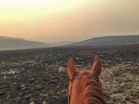
3 West Coast governors oppose offshore drilling

By: Associated Press

King 5
King 5 News

The governors of California, Oregon and Washington sent a letter to Interior Secretary Sally Jewel on Thursday to stress that they don’t want the possibility of drilling off of the West Coast.

The Interior Department is developing an updated plan for its Outer Shelf Oil and Gas Leasing Program, and the governors formally stated their opposition to the inclusion of any oil or gas lease sales off the coast as part of any new plan.

Govs. Jay Inslee, of Washington, Jerry Brown, of California, and John Kitzhaber, of Oregon, wrote that their three states “represent the fifth-largest economy in the world” and their ocean-dependent industries contribute billions of dollars to the region each year.

“While new technology reduces the risk of a catastrophic event such as the 1969 Santa Barbara oil spill, a sizeable spill anywhere along our shared coast would have a devastating impact on our population, recreation, natural resources, and our ocean and coastal dependent economies,” they wrote.

The governors, all Democrats, also stressed a commitment to develop a strategy to combat climate change.

“Oil and gas leasing may be appropriate for regions where there is state support for such development and the impacts can be mitigated,” they wrote. “However, along the West Coast, our states stand ready to work with the Obama Administration to help craft a comprehensive and science-based national energy policy that aligns with the actions we are taking to invest in energy efficiency, Oil and Gas Leasing Program alternative renewable energy sources, and pricing carbon.”

Inslee spokesman David Postman said that while there aren’t any current plans for West Coast leases, the governors want to ensure there aren’t any in the new plan.

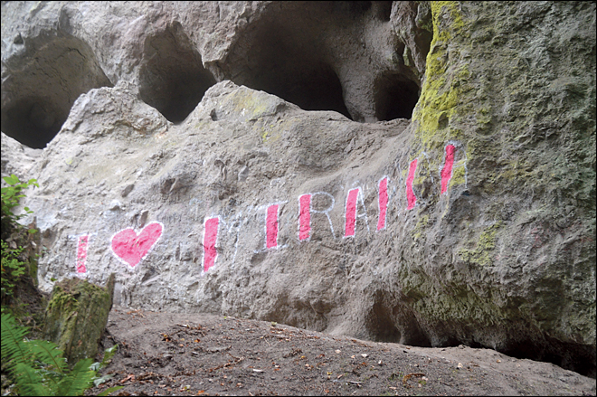
Affectionate graffiti mars sacred Indian site

This July 25, 2014 photo shows graffiti expressing affection for someone named Miranda on the sacred Jamestown S'Klallam site of Tamanowas Rock. (AP Photo/Peninsula Daily News, Joe Smillie)
This July 25, 2014 photo shows graffiti expressing affection for someone named Miranda on the sacred Jamestown S’Klallam site of Tamanowas Rock. (AP Photo/Peninsula Daily News, Joe Smillie)


By Associated Press Published: Aug 3, 2014


CHIMACUM, Wash. (AP) – Graffiti expressing affection for someone named Miranda has marred one of the most sacred sites for an American Indian tribe in Washington state.

Jamestown S’Klallam officials learned last month of the pink and white painting of “I (heart) Miranda” on the towering Tamanowas Rock northwest of Seattle. The 43-million-year-old monolith has been used for millennia by Salish Native Americans for hunting, refuge and spiritual renewal rituals.

In the Klallam language, Tamanowas means “spirit power.”

“It’s an incredibly important site for us,” Anette Nesse, chief operating officer for the tribe in Blyn, told The Peninsula Daily News.

The Jamestown S’Klallam tribe bought the rock and 62 surrounding acres from the Jefferson Land Trust for $600,000 in December.

Standing more than 150 feet tall, Tamanowas Rock is made up of a pair of basalt masses that shoot up through a dense forest, offering sweeping vistas of Admiralty Inlet, Whidbey Island and the Cascades.

The graffiti is about 8 feet long from end to end in letters that are roughly 3 feet tall.

The area is a favorite spot for rock climbers. In the past, however, the worst impact they left behind was campfire remnants.

The “I (heart) Miranda” tag also was painted on the Uptown Theatre in Port Townsend last month.

“I don’t know who Miranda is,” Nesse said. “She must mean a lot to somebody, but painting it on the rock is definitely not the best way to express it.”

Nesse and Bill Laubner, manager of the tribe’s facilities, are determining the best way to remove the graffiti without damaging the rock.

Nesse doesn’t think the painting was done with malice. “I just think whoever painted that didn’t realize how important the rock is to us,” she said.

Tamanowas Rock, also known as Chimacum Rock, was listed on the Washington Heritage Register in 1976. The tribe also is seeking to have it added to the National Register of Historic Places.

The rock, believed to have formed from molten lava, was used as a lookout for mastodon hunters, according to tribal spokeswoman Betty Oppenheimer.

Caves formed from gas bubbles during the rock’s development were used for spiritual vision quests.

Gov. Inslee’s Wastewater Plant Tour Highlights Sea Rise Woes

Dan Grenet (left), the manager of Seattle's West Point Wastewater Treatment Plant, leads Wash. Gov. Jay Inslee of a tour. The visit was intended to highlight the costs of climate change; in this case, as a result of seawater incursion at the facility. | credit: Ashley Ahear
Dan Grenet (left), the manager of Seattle’s West Point Wastewater Treatment Plant, leads Wash. Gov. Jay Inslee of a tour. The visit was intended to highlight the costs of climate change; in this case, as a result of seawater incursion at the facility. | credit: Ashley Ahear


By: Ashley Ahearn, KUOW


SEATTLE — When Washington Gov. Jay Inslee wanted to show the connection between climate change and an unpleasant and costly consequence for his constituents, he decided to tour a sewage treatment plant.

Inslee’s visit Tuesday to the West Point Wastewater Treatment Plant in Seattle’s Discovery Park was the latest stop on his statewide tour to raise awareness about the costs of climate change.

The problem the governor wanted to highlight: climate change is causing sea levels to rise. And that means homes and buildings that were built a safe distance from the water’s edge are increasingly becoming too close for comfort.

That message was also delivered by the White House Tuesday, when it issued a report that said global sea levels are currently rising at more than an inch per decade — and the rate appears to be increasing.

No one complained about the smell as treatment plant workers and managers led Inslee and other visitors through the facility. But there was a lot of talk about the problems with rising sea level.

Dan Grenet, the manager of the facility, showed Inslee some photographs hanging in the lobby. Waves crash over a cement wall.

“This is a photograph of Puget Sound coming into our facility – causes big problems in our pumps and piping systems and also, it’s a biological process here,” Grenet told the governor. “It doesn’t do well with salt water. Causes big problems.”

Saltwater intrusion could cost King and other shoreline counties tens of millions of dollars in infrastructure upgrades.

But during this visit, as with other stops on his climate change tour, the governor emphasized that the costs of climate change will hit from all directions.

“We’ve had $50 million in costs for fighting fires. Tens of millions of dollars of damage to the oyster industry,” Inslee said. “And here we don’t have an estimate at West Point but we know it’s significant because we know it’s not just this point its all these ancillary pumping stations that are going to have to be if not rebuilt, refortified to deal with sea water intrusion.”

Inslee’s latest task force on climate change has been charged with developing a plan to put a price on CO2 emissions. The plan is expected be presented to the state Legislature this fall.

Snoqualmie Tribe Donates $250,000 to Aid Eastern Washington Fire Victims


The Snoqualmie Tribe is donating $250,000 to assist in the relief efforts for those affected by the devastating fires burning in Eastern Washington. In total the Tribe is giving $200,000 to the American Red Cross Eastern Washington region designated to the 2014 fire victims and $50,000 to Washington Animal Search and Rescue.

“We are all part of a larger community, and felt in a time like this that it is important to reach out and help those in need. Our hearts go out to all of those affected by this massive fire, and hope that our contributions can help in the recovery and healing process,” said Carolyn Lubenau, tribal chairwoman.

After extensive research, the Tribe decided to place its donations with the American Red Cross and Washington Animal Search and Rescue. Both groups can directly benefit from the donations and make a difference in people’s lives. Officials including the Wenatchee Red Cross have said the best way for people to assist in the relief effort was through monetary donations.

“Our thoughts and prayers are with those who have suffered a loss due to a fire and also to those working so diligently to put it out,” adds Lubenau.

The fires burning in Eastern Washington are part of an eruption of lightning-sparked wildfires across Washington and Oregon that have scorched to date almost a million acres of land. The largest fire in Eastern Washington is the Carlton Complex fire that is the worst of Washington State’s seven fires.

Sea Star Disease Strikes Washington Marine Centers

July 28, 2014 | AP


PORT ANGELES, Wash. (AP) — The disease wreaking havoc on wild sea star populations on the West Coast has struck captive collections on Washington’s Olympic Peninsula.

The Peninsula Daily News reports Monday that sea stars at Port Townsend’s Marine Life Center and Feiro Marine Life Center in Port Angeles have died of the disease, known as sea star wasting.

In Port Townsend, 12 ochre stars have died, while the illness eliminated a species from the tanks in Port Angeles. Both centers pipe in ocean water for their tanks. Experts believe the disease is infectious and might be caused by bacteria or a virus.

Caretakers at the Olympic Peninsula’s marine science centers don’t intend to replace sea stars until they feel more confident they can keep them alive. They also want to avoid taking breeding adults that might be needed to replenish wild colonies.

New Report: Oso Landslide Rooted In Long History Of Slides

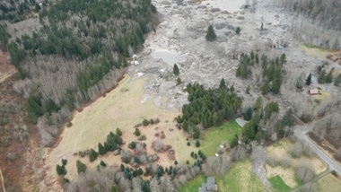
A photo taken immediately after the March 22 slide that killed 43 people and destroyed dozens of homes in Oso, Washington. A new scientific reports says a history of landslides and a huge volume of precipitation were big contributors to the slide. | credit: Washington Department of Transportation


By: Ashley Ahearn, KUOW

SEATTLE — Scientists have concluded that rain, groundwater seepage and a long history of big landslides likely contributed to the massive landslide of March 22 that killed 43 people and destroyed dozens of homes near Oso, Washington.

Those findings came out Tuesday, the result of a scientific team’s rapid-fire assessment of geology and localized factors.

Joe Wartman, a University of Washington associate professor of civil and environmental engineering and a co-lead author of the study, said rainfall very likely played a key role in the slide.

“It mobilized as the water entered the landslide mass. It raised the water pressure in that mass,” Wartman said, “And as a result the landslide mass lost its strength and it became a fluidized mass of earth and material.”

The U.S. Geological Survey estimates that 7.6 million cubic meters of earth slid down across the Stillaguamish River, spreading out for more than a kilometer.

The researchers also looked further back in history, reviewing evidence from a number of large landslides in the Stillaguamish Valley around Oso during the previous 6,000 years. The team estimated that, based on a review of carbon dating and maps of 15 similar historic landslides nearby, slides such as the March event have happened in the same area as often as every 400 to 1,500 years historically.

“The real different thing about that particular spot was how much it had failed in the very recent past,” said Dave Montgomery, a geomorphologist with the University of Washington and co-author of the report. “It had been chewed on a lot by prior failures.”

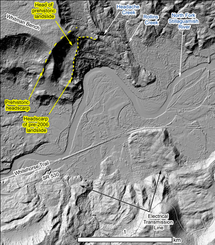
Screen Shot 2014-07-22 at 3.07.16 PM
A 2003 lidar map of ground conditions where the Oso slide occurred.


The report authors said the landslide occurred in two phases. The first slope failure was a repeat of previous slides that had been documented as far back as the 1950s at that site. The most recent one to contribute to the March slide took place in 2006.

The second phase of the March 22 event tapped into a much deeper landslide history at the site.

“You have the really big ones from thousands of years ago,” Montgomery said, “But why did the piece of the slope fail that did? It was different from some other areas up and down the valley due to the history of failure in recent decades, which exacerbated the stability problem.”

The report raised a question that was brought up in the immediate aftermath of the slide: what role did logging play? But the authors said that they were “not in a position to answer the question of what degree forest practices contributed to this slide.” Any conclusions would require further modeling and were beyond the scope of this four-day reconnaissance effort, they said.

Logging can contribute to weakened root strength, allowing hillsides to slough off in heavy rain. But Montgomery said the team was pretty comfortable ruling out that idea because the slide was too big and roots would have been too thin to make a difference in preventing the massive amount of earth from loosening.

Another potential connection to logging is from the removal of trees that would otherwise have absorbed some of the precipitation, preventing it from seeping deep into the soil and loosening it. Groundwater seems to have been a key contributor to the destabilization of the slope near Oso, the report authors concluded. Montgomery said the team saw seeps of water coming into the exposed face, or scarp, of the landslide from neighboring creek basins to the east.

“We located five or six groundwater seeps where water is coming out of the wall of the slide and forming a little stream that is running across the scar,” Montgomery said. That stream could have destabilized the earth far below the surface of the slide, contributing to its size and extensive runout zone.

The authors concluded that methods to identify and predict potential landslide runout zones need to be revisited and re-evaluated. The use of LIDAR imagery could also provide a great deal of assistance in gathering historic evidence that landslides of this magnitude have run across the valley before, said Jeff Keaton, a principal engineering geologist with AMEC Americas, who contributed to the report.

“That would be a really helpful step in understanding how widespread this kind of process actually is,” he said.

But there’s more digging to be done, literally, said Joe Wartman.

“The hole we have at this point is understanding what was going on underneath the ground surface,” Wartman said. “I think the next big thing is drilling holes into that landslide and the nearby vicinity to get an understanding of what is underneath that large landslide.”

The authors called for further modeling in order to better understand to what degree logging or the Stillaguamish River, which was eating away at the toe of the slope, may have contributed to the catastrophic slide.

The USGS and others will be conducting field research in the coming months. You can read the full report here.

Critics say proposed rules on fish consumption insufficient

Tribal leaders are skeptical of a proposal by Gov. Jay Inslee to set new water-quality standards.


By Lynda V. Mapes, Seattle Times, July 21, 2014


Some tribal leaders and environmental groups say a water-pollution cleanup plan proposed by Gov. Jay Inslee this month is unacceptable because while it tightens the standards on some chemicals discharged to state waters, it keeps the status quo for others.

Inslee is drafting a two-part initiative to update state water-quality standards, to more accurately reflect how much fish people eat, and to propose legislation to attack water pollution at its source. The fish-consumption standards have the effect of setting levels for pollutants in water: The more fish people are assumed to eat, the lower the amount of pollution allowed.

Inslee decided that lowering some standards wouldn’t create a big-enough benefit to human health to justify the economic risk for businesses, said Kelly Susewind, water-quality program manager for the state Department of Ecology.

“The realistic gains on the ground didn’t warrant that concern and disincentive to invest in our state,” Susewind said.

That’s because the rules regulate state permits for dischargers, such as industrial manufacturers and wastewater-treatment plants — but that isn’t where most of the pollution is coming from.

Setting tougher standards for some pollutants would also result in levels too low to detect or manage with existing technology — but would create a regulatory expectation that could cloud future business investment, Susewind said.

“The concern is that we set in motion a chain of events where it is inevitable they can’t comply. If they are worried they will cease to invest in 30 years, they are not going to invest today; that is the long-term picture that caused the uncertainty.”

In the case of PCBs — polychlorinated biphenyls, industrial chemicals used as coolants, insulating materials, and lubricants in electric equipment — setting a limit below the existing limit of 170 parts per quadrillion wouldn’t improve people’s health, Susewind said. That’s because most PCBs are entering waterways from other sources, including runoff. “It is not the most effective place, to put the pinch on dischargers,” Susewind said.

The problem is that the Clean Water Act, under which the standards are issued, doesn’t reach beyond so-called point sources: pollution in water discharged from pipes by industries and others regulated by Ecology and the federal Environmental Protection Agency (EPA).

“A lot of our challenge is finding ourselves with only one tool,” said Carol Kraege, who leads toxics reduction at Ecology. “Getting toxics out of our water with just the Clean Water Act is not enough.”

To gain new tools to clean up state waters, Inslee has asked Ecology to put together legislation to expand its authority to ban certain chemicals, to keep them from getting in the water in the first place. The legislation, which is still being drafted, is intended to address so-called non-point sources of pollution.

The governor has said he won’t submit a final water-quality rule to the EPA for approval until after the legislature acts.

Christie True, director of King County Natural Resources and Parks, which runs the county’s wastewater-treatment plants, said she was encouraged by the governor’s approach. “We have to be focused on outcomes,” True said.

“The thing I was really happy about was he said we can’t just rely on regulating the same old sources if we want to improve water quality. I know it is going to be very challenging to take these issues to the Legislature, but that is where we need to head to have a better outcome.”

The debate now under way arose from the state’s need to update the water-quality standards that address health effects for humans from eating fish. The state’s rules today assume a level of consumption so low — 6.5 grams a day, really just a bite — that it is widely understood to be inadequately protective, especially for tribes and others who eat a lot of fish from local waters.

The standard also incorporates an incremental increase in cancer risk in that level of consumption.

Inslee has proposed greatly increasing the fish-consumption standard in the new rule, to 175 grams per day, a little less than a standard dinner serving. But he also upped the cancer risk, from 1 in 1 million under current law, to 1 in 100,000 in the new standard. That was to avoid imposing tighter standards for some pollutants.

That isn’t good enough for tribal leaders who say they want tougher protection now — for all pollutants, not just some. “Holding the line isn’t good enough,” said Dianne Barton, water-quality coordinator for the Columbia River Intertribal Fish Commission.

Counting on the Legislature to grant new authority to Ecology and money to back it up is also a shaky proposition, some said. “That is a big gamble,” said Chris Wilke, executive director of Puget Soundkeeper, a nonprofit environmental group that sued the EPA to force Washington to update its standards. Delay, meanwhile, “is more business as usual,” Wilke said.

Brian Cladoosby, chairman of the Association of Washington Tribes and the Swinomish Indian Tribal Community, said tribes are going to take their case directly to the feds both at Region 10 EPA and in the EPA administrator’s office in Washington, D.C., and insist no change be made in the cancer risk.

“In our minds, the bar hasn’t moved that much,” Cladoosby said. “It took 100 years to screw up the Salish Sea; hopefully, it won’t take another 100 years to clean it up. But we have to start somewhere.”

San Juan Island’s Iconic House Posts Celebrate 10 Years

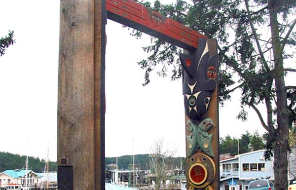
source: susanpoint.comSusan Point's 'Interaction' house posts at Friday Harbor on San Juan Island, Washington. Source: susanpoint.com
source: susanpoint.com
Susan Point’s ‘Interaction’ house posts at Friday Harbor on San Juan Island, Washington. Source: susanpoint.com


Richard Walker, 7/21/14, Indian Country Today


Residents of San Juan Island, Washington, the original home of the Lummi, Samish and Songhees peoples, are raising money for the care and preservation of house posts that overlook the harbor in the port town of Friday Harbor.

The house posts were carved by noted artist Susan Point, Musqueam, and acquired by residents 10 years ago to publicly honor the indigenous heritage of the island. The house posts, titled Interaction, tell the story of the interdependence of humans and animals in caring for the environment that sustains them.

“From the time of its unveiling, Interaction has become a gathering place for islanders and visitors—especially children, awed by the sculpture’s size, engaging motif, and deep, colorful carvings,” Barbara Marrett writes, in an article posted to SanJuanJournal.com. “Because children are drawn to touching the cougar scratches on the woman’s leg, over the years the paint and wood [have] been worn down in this area and other places where they have been loved and climbed upon.”

'Interaction' house posts by Susan Point. Source: susanpoint.com.
‘Interaction’ house posts by Susan Point. Source: susanpoint.com.


Interaction, which cost $65,000 in 2004, is now estimated to be worth $400,000, according to Marrett.

The house posts will be restored and repainted by a team of artists from Point’s studio. A community/Tribal celebration will follow the completion. Questions: Linda@sjihome.com.


Read more at http://indiancountrytodaymedianetwork.com/2014/07/21/san-juan-islands-iconic-house-posts-celebrate-10-years-155976

Alabama To Help Fight NW Fires

Source: Associated Press

Alabama Forestry Commission officials say firefighters from throughout the state are helping respond to wildfires in Oregon and Washington state.

Officials said in a release Tuesday that five firefighters have been sent to tackle wildfires in Oregon and two have been sent to battle a blaze in Washington State.

Alabama State Forester Greg Pate says Alabama Forestry Commission firefighters accepted a 16-day assignment through an agreement with the U.S. Forest Service and have previously helped fight western wildfires in recent years.

Forestry officials say Alabama has seen measurable rainfall this summer while many western states are faced with drought conditions. Officials say the dry conditions allow wildfires to quickly become difficult to control.

Wildfire Season Starts Early And With A Vengeance

By Chris Lehman, NW News Network


So far, more than 150 homes in Washington state have been destroyed in what veteran firefighters are calling the worst fire season in decades.


Fires have scorched thousands of acres of ranchland in southeast Oregon.
Credit Brooke Nyman / Oregon Cattleman’s Association


In neighboring Oregon, firefighters are stretched thin by more than a dozen blazes burning at once.

Veteran firefighter Al Lawson came to a community meeting in central Washington to meet with residents displaced by the raging Carlton Complex Fire. It’s among the largest wildfires in the state’s recorded history.

“In my 30 years, I’ve never seen fire behavior like this,” he said. “Nothing to compare.”

Governor Jay Inslee toured the devastation over the weekend. He called it an unprecedented firestorm.

“Our state is stretched beyond imagination,” he said.

Inslee says the fact that it’s only mid-July is an ominous sign.

“Typically the fire season doesn’t really get going until August,” he said. “So we have at least two more months in the fire season and we have already burned twice as many acres as the average.”

Oregon has been spared the same level of devastation in terms of lost property. But the Oregon Department of Forestry says so far the sheer number of acres burned this summer is seven times more than a typical fire season.

On a more positive note, the agency’s Cynthia Orlando says cooler weather for the next few days could help slow things down.

“We’re getting a lit bit of a respite but you know, everybody’s on alert here,” Orlando said.

Temperatures are expected to soar back into the 90s by the end of the week.