Ashley Ahearn/KUOW
by Ashley Ahearn KUOW
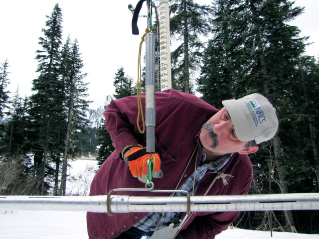
Scott Pattee stands well over 6 feet, but he’s dwarfed by the tall white tube set up near the Stevens Pass Ski Area to measure snow depth.
Little black numbers marking inches of snow ascend the side of the tube. The top number reads 250 inches, an amount of snow that’s hard to imagine right now.
Most of the mountains around Pattee are green and brown, not white – even though it’s officially still winter until March 19 arrives.
And the snow depth, according to the tower?
“We have about 30 inches,” said Pattee, a water supply specialist with the Natural Resources Conservation Service. “Normally we would have closer to 150 this time of year. It’s not good.”
Actually, it’s really bad. Record-breaking bad.
Pattee has been monitoring snow levels in Washington for more than 20 years. The data he gathers helps scientist study climate trends, farmers plan their growing seasons, hydropower operators manage their reservoirs and municipalities provide water to citizens.
This year is on track to be one of the lowest snow years on record. Across Washington state, average snowpack is 71 percent below normal levels. In some places, including the Olympic Peninsula, snowpack is 90 percent below normal levels.
Things are looking even worse in Oregon. Statewide, average snowpack is 76 percent below normal levels.
“One of our longest-monitored sites, near Bend, has the lowest snowpack ever recorded, breaking the 1977 record,” said Julie Koeberle, a hydrologist in Oregon with the Natural Resources Conservation Service. The Bend site has been monitored since the early 1950s.
“All eyes will be pointing on southern and southeastern Oregon if things don’t improve,” Koeberle said. Some of the lowest snow levels can be found in those areas, where water scarcity has created drought conditions in recent years.
However, despite dire warnings about low snowpack, things aren’t looking desperate, yet on all fronts. That’s because the Northwest is seeing normal or above-average amounts of overall precipitation, it’s just coming as rain instead of snow.
“The snowpack is bad but the overall conditions aren’t that horrible. It’s above normal precipitation all over the state, and so we’re in pretty good shape there for now,” Pattee said, adding that the region could see drought later in the summer.
The Bonneville Power Administration manages 31 federal dams on the Snake and Columbia rivers and provides one-third of the electricity consumed in the Northwest. Mike Hanson, spokesman for BPA, said things are looking normal.
“We’re doing just fine at the moment,” Hanson said, adding that the reservoirs above the dams are at normal levels. The Columbia River’s headwaters are in the Canadian Rockies, which are seeing normal snow levels this year.
“When we’re looking out our windows here and it seems very little snow, mild winter, conditions up at ski resorts are horrible, but that’s not really an indication of the total picture,” Hanson said. “Right now it looks like all systems are running normally and we are closely watching what is happening out there. We feel OK with where we’re at.”
The City of Seattle gets its water supply from the Tolt and Cedar rivers east of the city. Reservoirs managed by Seattle Public Utilities are currently above normal, and it plans to keep them full, even as it anticipates a warm dry spring with little additional rainfall.
“We don’t need snow to have a good water supply as long as it rains, which it has been,” said James Rufo-Hill, meteorologist and climate adaptation specialist with Seattle Public Utilities. “We’ll hold a little more water in our reservoirs and constantly manage that flow. We can meet demands throughout the summer.”
Resource managers, hydropower operators and others have referred to the snow levels and warm temperatures this year as “anomalous.” Amy Snover, director of the Climate Impacts Group at the University of Washington, agrees, but she said it’s an anomaly worth noting.
“It’s a really useful year in the sense that this is the kind of year that all the climate models tell us to expect,” Snover said. “The future looks like this. The future looks like less snow because of warmer temperatures but not necessarily less precipitation.”
Snover said water managers and hydropower operators need to be nimble.
“In many cases, the water managers who are paying attention to conditions can change the way they manage their systems and catch that water as it’s going down the river because it fell as rain instead of snow,” she said.
But for other basins or municipalities that are heavily reliant on surface water, without reservoirs to store it, the lack of snow this year presents a challenge. Places like Sequim and Port Townsend on Washington’s Olympic Peninsula are heavily reliant on rivers that are largely fed by snowpack from the Olympic Mountains, which are at record-setting low snow levels.
In drier parts of the region, meeting irrigation demands for agriculture could also prove challenging later on in the summer and early fall.
Pattee with the Natural Resources Conservation Service also cautioned that the wet, warm spring has started an early growing season, which could provide more fuel for wildfires later on in the dry season. For now he said the biggest impacts of low snow levels this year will be felt by recreationists and fish.
Without the strong pulse of cold snow melt, some Northwestern rivers could prove less hospitable to spawning salmon and their out-migrating young, Pattee said.
Regional water managers will brief Washington Gov. Jay Inslee on the snow situation early next week. Pattee said it’s too early to say if a drought declaration is in order but it is a concern.
“We’re going to have to sleep with one eye open this spring and summer and really keep a close eye on conditions and see which way the wind blows,” he said.
