Swinomish tribe worries rising sea levels threaten tradition, culture

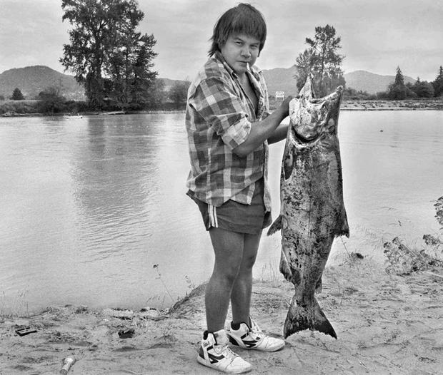
Scott Terrell photoTribal fisherman Randy Fornsby hoists a chinook salmon on the bank of the Skagit River west of Mount Vernon, Wash., Sept. 2, 1987. The Swinomish and Upper Skagit tribes shared a fishing area just upriver from where the Skagit breaks into its north and south forks.
Scott Terrell photo
Tribal fisherman Randy Fornsby hoists a chinook salmon on the bank of the Skagit River west of Mount Vernon, Wash., Sept. 2, 1987. The Swinomish and Upper Skagit tribes shared a fishing area just upriver from where the Skagit breaks into its north and south forks.


By: Kimberly Cauvel, Skagit Valley Herald, August 31, 2014


LA CONNER, Wash. – With 95 percent of the Swinomish Indian Tribal Community’s reservation borders on the water, the tribe is concerned about the rise in sea level and storm surges expected as the planet warms.

As sea level rise pushes high tides and winter storm surges farther inland, coastal tribes in the Northwest worry that their archaeological sites will be wiped out, Swinomish Tribal historic preservation officer Larry Campbell said. They also worry that traditional food sources like salmon and oysters may be affected.

Campbell said food and medicine resources used by tribes around the country have moved or disappeared altogether in some places from where they were traditionally gathered, which is believed to be a result of the changing climate and shifting weather patterns. Those changes affect not only physical access to the natural resources, but the cultural well-being of the tribes.

“It’s important when you look at overall health to look at not just the foods and the resources, but the gathering,” Campbell said. “There’s a process of gathering these things that’s traditional in nature.”

Traditions are passed down through generations as elders share family gathering secrets with their next of kin, he said.

The Swinomish tribe has gained national recognition for its commitment to protecting the culture and natural resources of the Skagit Valley in the face of climate change and is gearing up to begin a new research project. Building off past studies, the tribe will evaluate both the physical and social impacts climate change may have on local near-shore environments.

Swinomish environmental health analyst Jamie Donatuto said the study will build upon earlier research by looking at indigenous health indicators, which take into account cultural, familial and emotional aspects of the impacts climate change may have on the natural resources the tribe values.

Over the course of the three-year study, Swinomish environmental specialist Sarah Grossman will lead efforts to monitor waves and winds on the shorelines during the winter, when storm surges roll in. She will also lead beach surveys to document characteristics like sediment, wood debris and eelgrass cover.

Donatuto will lead the social science side, organizing a series of spring workshops to invite the community to review and discuss the scientific data collected.

“You can’t assess health without actual conversations with community members,” she said.

A $756,000 U.S. Environmental Protection Agency Science to Achieve Results program grant was awarded in June to support the multiyear project.

Swinomish intergovernmental affairs liaison Debra Lekanof said the Swinomish have invested $17 million in collaborative work on the nation’s natural resources over the past 10 years.

“We’re protecting the universal resource rather than the tribal resource. We’re doing a lot more for the state and the county, and then in the end the tribe benefits by taking care of the whole,” Campbell said. “We’re a very aggressive tribe when it comes to our environment.”

The tribe has also been chosen as a finalist for the Harvard Project on American Indian Economic Development’s Honoring Nations Program. The program, run by the John F. Kennedy School of Government at Harvard University, “identifies, celebrates and shares excellence in American Indian tribal governance.” This year, the tribe gained its place among 18 finalists in the running for the single “High Honor” because of its climate change initiative. The winner will be announced in October.

The Swinomish Indian Senate passed a proclamation on its climate change initiative Oct. 2, 2007, that marked the start of the tribe’s commitment to addressing the potential effects of climate change. The tribe developed an Impact Assessment Technical Report in 2009 and a Climate Adaptation Plan in 2010 that have provided a framework for other tribes to follow, and has continued to conduct related research, Donatuto said.
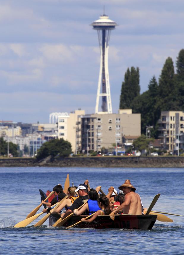
Associated Press photoA tribal canoe, in view of the Space Needle, arrives July 20, 2011, at Seattle’s Alki Beach. The landing of about a dozen canoes marked one leg of an annual journey of tribal canoes from the Salish Sea, heading to Swinomish, Wash.
Associated Press photo
A tribal canoe, in view of the Space Needle, arrives July 20, 2011, at Seattle’s Alki Beach. The landing of about a dozen canoes marked one leg of an annual journey of tribal canoes from the Salish Sea, heading to Swinomish, Wash.


International Team Maps Nearly 200K Glaciers in Quest of Sea-Level Rise Estimates


Chenega Glacier
Chenega Glacier

University of Colorado-Boulder May 7, 2014.

An international team led by glaciologists from the University of Colorado Boulder and Trent University in Ontario, Canada has completed the first mapping of virtually all of the world’s glaciers — including their locations and sizes — allowing for calculations of their volumes and ongoing contributions to global sea rise as the world warms.

The team mapped and catalogued some 198,000 glaciers around the world as part of the massive Randolph Glacier Inventory, or RGI, to better understand rising seas over the coming decades as anthropogenic greenhouse gases heat the planet. Led by CU-Boulder Professor Tad Pfeffer and Trent University Professor Graham Cogley, the team included 74 scientists from 18 countries, most working on an unpaid, volunteer basis.

The project was undertaken in large part to provide the best information possible for the recently released Fifth Assessment of the Intergovernmental Panel on Climate Change, or IPCC. While the Greenland and Antarctic ice sheets are both losing mass, it is the smaller glaciers that are contributing the most to rising seas now and that will continue to do so into the next century, said Pfeffer, a lead author on the new IPCC sea rise chapter and fellow at CU-Boulder’s Institute of Arctic and Alpine Research.

“I don’t think anyone could make meaningful progress on projecting glacier changes if the Randolph inventory was not available,” said Pfeffer, the first author on the RGI paper published online today in the Journal of Glaciology. Pfeffer said while funding for mountain glacier research has almost completely dried up in the United States in recent years with the exception of grants from NASA, there has been continuing funding by a number of European groups.

Since the world’s glaciers are expected to shrink drastically in the next century as the temperatures rise, the new RGI — named after one of the group’s meeting places in New Hampshire — is critical, said Pfeffer. In the RGI each individual glacier is represented by an accurate, computerized outline, making forecasts of glacier-climate interactions more precise.

“This means that people can now do research that they simply could not do before,” said Cogley, the corresponding author on the new Journal of Glaciology paper. “It’s now possible to conduct much more robust modeling for what might happen to these glaciers in the future.”

As part of the RGI effort, the team mapped intricate glacier complexes in places like Alaska, Patagonia, central Asia and the Himalayas, as well as the peripheral glaciers surrounding the two great ice sheets in Greenland and Antarctica, said Pfeffer.  “In order to model these glaciers, we have to know their individual characteristics, not simply an average or aggregate picture. That was one of the most difficult parts of the project.”

The team used satellite images and maps to outline the area and location of each glacier. The researchers can combine that information with a digital elevation model, then use a technique known as “power law scaling” to determine volumes of various collections of glaciers.

In addition to impacting global sea rise, the melting of the world’s glaciers over the next 100 years will severely affect regional water resources for uses like irrigation and hydropower, said Pfeffer. The melting also has implications for natural hazards like “glacier outburst” floods that may occur as the glaciers shrink, he said.

The total extent of glaciers in the RGI is roughly 280,000 square miles or 727,000 square kilometers — an area slightly larger than Texas or about the size of Germany, Denmark and Poland combined. The team estimated that the corresponding total volume of sea rise collectively held by the glaciers is 14 to 18 inches, or 350 to 470 millimeters.

The new estimates are less than some previous estimates, and in total they are less than 1 percent of the amount of water stored in the Greenland and Antarctic ice sheets, which collectively contain slightly more than 200 feet, or 63 meters, of sea rise.

“A lot of people think that the contribution of glaciers to sea rise is insignificant when compared with the big ice sheets,” said Pfeffer, also a professor in CU-Boulder’s civil, environmental and architectural engineering department. “But in the first several decades of the present century it is going to be this glacier reservoir that will be the primary contributor to sea rise.  The real concern for city planners and coastal engineers will be in the coming decades, because 2100 is pretty far off to have to make meaningful decisions.”

Part of the RGI was based on the Global Land Ice Measurements from Space Initiative, or GLIMS, which involved more than 60 institutions from around the world and which contributed the baseline dataset for the RGI. Another important research data tool for the RGI was the European-funded program “Ice2Sea,” which brings together scientific and operational expertise from 24 leading institutions across Europe and beyond.

The GLIMS glacier database and website are maintained by CU-Boulder’s National Snow and Ice Data Center, or NSIDC. The GLIMS research team at NSIDC includes principal investigator Richard Armstrong, technical lead Bruce Raup and remote-sensing specialist Siri Jodha Singh Khalsa.

NSIDC is part of the Cooperative Institute for Research in Environmental Sciences, or CIRES, a joint venture between CU-Boulder and the National Oceanic and Atmospheric Administration.

– See more at: http://www.colorado.edu/news/releases/2014/05/06/international-team-maps-nearly-200000-glaciers-quest-sea-level-rise#sthash.W6vK18yo.dpuf

Coastal cities prepare for rising sea levels

Source: McClatchy Newspapers

WASHINGTON – Americans in coastal areas, particularly on the East and Gulf coasts, will confront challenging questions in the coming years as leaders determine how to protect millions of people in the face of rising sea levels and more intense storms.

Should cities rebuild the boardwalks in New Jersey shore towns? Should the government discourage people from rebuilding in areas now more vulnerable to flooding? How much would it cost to protect water and sewer systems, and subways and electrical substations from being inundated in the next storm?

Leaders from coastal communities along the East Coast gathered in New York City on Wednesday to talk about the consequences of Hurricane Sandy, as well as how they will address future sea level rising. The conference was sponsored by the Union of Concerned Scientists, a nonprofit, nonpartisan science advocacy group.

“What we really got a glimpse at was our collective future,” said Joe Vietri, who heads coastal and storm risk management for the U.S. Army Corps of Engineers and is heading up a comprehensive study of Sandy.

Rising sea levels caused primarily by global warming could worsen the effects of storms such as Sandy, particularly when it comes to storm surge. Since 1992, satellites have observed a 2.25-inch rise in global sea levels.

Just before Sandy, sea surface temperatures were about 5 degrees Fahrenheit above the 30-year average for the time of year. Scientists who studied the storm determined that about 1 degree was likely a direct result of global warming.

With every degree Fahrenheit rise in temperature, the atmosphere can hold 4 percent more moisture. As a result, Sandy was able to pull in more moisture, fueling a stronger storm and magnifying the amount of rainfall by as much as 5 percent to 10 percent compared with conditions more than 40 years ago.

Coupled with higher overall sea levels, the intense storm meant more water surging onshore and penetrating farther inland. The storm’s effects prompted officials in Wilmington, N.C., to look at its vulnerabilities if seas rise up to one meter by the end of the century.

“People are listening, people are ready to take some actions,” said Phil Prete, a senior environmental planner for the city.

The officials spent less time discussing the cause of rapid sea level rise: how to slow the carbon emissions that are heating up the Earth and warming the oceans. Many public officials in coastal communities instead are focusing on what they say are the consequences of global warming.

They have no choice, said Kristin Jacobs, mayor of Broward County, Fla., where extreme tides during Hurricane Sandy washed out portions of Fort Lauderdale’s iconic beachfront highway.

“Almost all of us are living in very low-lying areas,” she said. “There are many lessons in South Florida already learned from multiple hurricanes. We have learned from those hurricanes, we have learned to plan for the future, and we’ve learned that this is our new normal.”

The causes are also a settled question in Hoboken, N.J., where an estimated 500 million gallons of Hudson River water inundated the town and stayed for nearly 10 days, said Stephen Marks, Hoboken’s assistant business administrator. He called on the federal government and states to take a leadership role in addressing climate change, particularly in communities that are vulnerable to its effects.

“The debate about climate change is essentially over,” Marks said. “Hurricane Sandy settled that for, I would say, a majority of the residents in our city.”

But coastal populations are particularly vulnerable, and growing. The National Oceanic and Atmospheric Administration last month issued a report showing that already crowded U.S. coastal areas will see population grow from 123 million people in 2010 to nearly 134 million people by 2020. That puts millions more people at risk from storms such as Sandy.

People may be aware of the consequences of climate change, but it hasn’t seemed to have stopped anyone from moving to the beach – or hurt property values, said Vietri, of the Army Corps of Engineers. He noted that communities suffered far less damage if there were sand dunes or other protective measures, such as substantial setbacks for homes.

“You still have communities rebuilding almost exactly where they were prior to the storm coming,” Vietri said. “You continue to have a situation where we have a tremendous population density living in high-hazard areas.”