So here is something cool: Google three words – tribes largest employers – and dozens of entities pop right up. This is our generation’s success story because across the country, in communities large and small, tribal governments and enterprises are writing lots and lots of paychecks. Tribes are big business.
An Idaho economic impact report summed up this sort of progress well. An economist said: “The study confirms what tribal planners already know – the tribes are rapidly growing, significant engines in the state.”
But that progress takes on a different context in the age of the Affordable Care Act. Tribes are employers. And that means there is a long “to do list” in order to meet the requirements under the healthcare reform law. If a tribe employs more than 50 workers, then insurance has to be offered that meets the requirements of the law and costs the employee less than 9.5 percent of their annual income. (Laura Bird and Jim Roberts of the Northwest Portland Area Indian Health Board wrote an excellent summary of the requirements.)
It’s important to remember that most Americans, including American Indians and Alaska Natives, get their health insurance through work. (I’ve written this before and will add again, this is uniquely American and dumb. We should not tie our jobs to our health care. But that’s where we are at.)
Right now most of the employer provisions are on hold. The Obama administration gave large employers more flexibility on insurance rules and delayed the implementation for mid-size employers until 2016. That means tribes will have more time to get ready. A good thing, too. Once all of the employer provisions begin, the penalty for being wrong could cost tribes some $2,000 per employee.
However Mark J. Mazur, assistant Treasury secretary for tax policy, wrote that the delay “will allow us to consider ways to simplify the new reporting requirements consistent with the law. Second, it will provide time to adapt health coverage and reporting systems while employers are moving toward making health coverage affordable and accessible for their employees.”
Critics of the Affordable Care Act are not happy about these changes, saying it’s more evidence the law does not work. The administration, however, is trying to make certain there are no more major glitches (such as the website) and this is a logical delay.
Another twist that impacts Indian country is that a major retailer, Target, is ending its insurance options for part-time employers because the workers would likely get a better deal through the exchanges (including tax subsidies). I suspect this would be the same for tribes and tribal enterprises.
The whole question of employment under the Affordable Care Act has taken on a new dimension with the recent report by the Congressional Budget Office. Republican opponents of the law cited this report as proof that some 2.5 million people will lose their jobs as a result. The CBO this week refuted that. The idea the CBO tried to measure was that many people would quit working because they had more choices.
The back and forth from CBO is great. “Q: Will 2.5 Million People Lose Their Jobs in 2024 Because of the ACA? A: No, we would not describe our estimates in that way.”
But, CBO points out, “there is a broader question as to whether the society and the economy will be better off as a result of those choices being made available,” a February 10 blog post from director Doug Elmendorf said. “Even though the individuals making decisions to work less presumably feel that they will be happier as a result of those decisions, total employment, investment, output, and tax revenue will be smaller. (Those effects are included in CBO’s budget and economic projections under current law.) To be sure, the health insurance system in place prior to the ACA generated its own distortions to people’s work decisions, but many of the decisions to work less under the ACA will be made possible by government-funded subsidies, the burden of which will be borne largely by other people … Hence, whether voluntary reductions in hours worked owing to the ACA are good or bad for the country as a whole is a matter of judgment.”
I think this particular debate misses an important point. The Affordable Care Act will free independent operators because it was too expensive to buy single policies on the open market. Over time my guess is that more people will launch a new business because health insurance won’t be a factor. It will be available and affordable.
But that brings us back to the political loop. Those that opposed the Affordable Care Act remain against it. And vice versa. Nothing in the news this week resolves the deep divisions.
Of course tribes and tribal enterprises – large employers, these days – now have a new means to contribute resources to the Indian health system. Fully-insured tribal employees will be a net asset every time they show up at an IHS, nonprofit or tribally-managed clinic or hospital. Tribal employees will be the prime customer.
Mark Trahant is the 20th Atwood Chair at the University of Alaska Anchorage. He is a journalist, speaker and Twitter poet and is a member of The Shoshone-Bannock Tribes. Comment on Facebook at: www.facebook.com/TrahantReports.
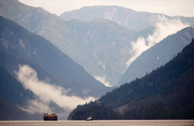
Dogwood Initiative executive director Will Horter said pipeline opposition is always stronger in polls when tanker routes and the possibility of oils spills are mentioned as part of the Northern Gateway project. Photograph by: JONATHAN HAYWARD , THE CANADIAN PRESS
Results not surprising in survey commissioned by environmental groups
Nearly two thirds of British Columbians are opposed to the $6.5-billion Northern Gateway pipeline and the tankers it will bring to the northern coast, according to a poll commissioned by environmental groups.
Conducted between Jan. 13-19, the Justason Market Intelligence poll of 600 people also found that 64 per cent (the same number that are opposed) believe the project will definitely or probably be built. The margin of error of the combined telephone and online poll is plus or minus four per cent.
The survey showed that 92 per cent were aware of the project, which will carry diluted bitumen from the Alberta oilsands to Kitimat for transport by tanker overseas to open up Asian markets.
The poll was commissioned by the Dogwood Initiative, ForestEthics Advocacy, Northwest Institute for Bioregional Research and West Coast Environmental Law.
The Enbridge pipeline project received approval last month from a joint panel federal review of the National Energy Board and the Canadian Environmental Assessment Agency.
Several First Nations and environmental groups have already launched court action against the panel decision.
Prime Minister Stephen Harper’s Conservative government has until the middle of this year to grant approval.
The findings showed that four times as many of those surveyed “strongly” oppose the project (50 per cent) than who “strongly” support the project (12 per cent). Another 17 per cent somewhat support the project.
The majority-opposition finding is not an unusual for a poll commissioned by environmental groups, which generally highlight in their questions the introduction of super tankers and the possibility of oil spills.
Dogwood Initiative executive director Will Horter said opposition is always stronger in polls when tankers are mentioned as part of the Northern Gateway project.
“People have very strong concerns about oil pipelines, but have deep, deep concerns about the oil tankers,” said Horter.
Business and industry-commissioned polls, which tend to highlight the economic benefits of Northern Gateway, usually find higher support for the project.
A B.C. Chamber of Commerce-commissioned poll released in December found nearly 50 per cent support for Northern Gateway.
The Justason poll also found that 51 per cent distrust the joint review panel process, while 32 per cent trusted it.
If Premier Christy Clark’s five conditions for supporting heavy oil being transported through B.C. are met, 49 per cent said they would be a lot or a little bit more supportive of the project.
The B.C. Chamber poll had found that should the project meet the five conditions, support increased to 63 per cent.
Clark’s conditions include the passing of an environmental review, creating world-leading marine and land spill prevention and recovery systems, addressing First Nations’ rights and receiving a fair share of economic benefits.
Since November 27, 2013, the Alaska Department of Environmental Conservation (DEC) has been receiving public comments on Flint Hill Resources’ request to reduce its liability to clean up drinking water at its North Pole refinery that is seriously contaminated with sulfolane, an industrial solvent used in the production containing gasoline.
The DEC issued a “letter of conditional approval for revised human health risk assessment for the Flint Hills North Pole Refinery regarding the alternative cleanup level for sulfolane in local groundwater,” and a public notice allowing for comments. The deadline for public comment is February 10, 2014.
On February 5, Flint Hills Resources Alaska, a subsidiary of Koch Industries, announced that it would be closing its refinery this summer, laying off 80 employees, and leaving Alaska after contaminating the municipal water supply and water wells for more than 300 families. Company officials cited the cost of cleaning up the contaminated water as one reason for closing the refinery.
Last year, the Alaska DEC established a site-specific alternative cleanup level for sulfolane in groundwater of 14 parts per billion (ppb). DEC decided on that level using new toxicity data and on the advice of state and federal agencies.
But Flint Hills wants a lower alternative cleanup level of 362 ppb, leaving 348 ppb of contamination in Alaska’s waters. According to the DEC’s Contaminated Sites program, Alaskans should not drink water if it has over 25 ppb of sulfolane. “If your water well results showed above 25 parts per billion sulfolane, we advise you not drink the water,” cites a warning on its website.
At the National Toxicology Program Board of Scientific Counselors meeting in December 2011, Dr. Chad Blystone of the National Institute of Environmental Health Sciences reported that sulfolane is a highly polar chemical that is presumed not to break down and is absorbed by plants (your food).
The sulfolane contamination in the North Pole affects more than 300 wells, and the exposure may last up to 20 years, according to the DEC. Contamination from the plume is estimated to be over 2.5 miles wide and three miles long.
Some studies observe symptoms of neurotoxicity: convulsions, seizures, hyper/hypo-activity, and hypothermia. In a sulfolane inhalation study on animals, Dr. Blystone reported 37 days mortality in monkeys, chronic lung inflammation in all animals, chronic liver inflammation in rats after 90 days, and decreased white blood cells and mortality in dogs and monkeys.
Responding to news of the refinery closure, Rep. Don Young said, “We see companies like Flint Hills shuttering their operations due to deteriorating conditions caused by diminished supplies and onerous regulation.”
Onerous regulations, like cleaning up after your mess?
“This is a sad day for the entire Interior region and Alaska as a whole,” said Rep. Pete Higgins, R-Fairbanks. “We will be looking to the governor for his leadership in the coming days, which will hopefully address the Dept. of Environmental Conservation decisions that forced Flint Hills into making this announcement. This will have far-reaching impacts economically to the Interior. The news hit us hard and fast today, and we will be working with the governor and the DEC to alleviate the impact to the families and businesses affected by the shutdown.”
Rep. Steve Thompson, R-Fairbanks, said, “The announcement today regarding Flint Hills shutting its doors came as a shock. We will continue to monitor the situation as to loss of jobs, groundwater contamination, and the economic impact this will have on our community.”
But Mike Wenstrup, Chair of the Alaska Democratic Party, said what a lot of Alaskans are thinking: “Interior Alaska knows actions speak louder than words: The Koch Brothers are closing the refinery and tossing Alaska aside while choosing to invest hundreds of millions in political attacks. It shows how little they care about Alaska and Alaskans.”
Ann Farris, an engineer with Alaska DEC who served as on the multiagency team formed to deal with the sulfolane contamination said, “This is the biggest plume of sulfolane groundwater contamination ever, and it’s the biggest groundwater-contamination plume involving an industrial substance in Alaska.”
I don’t live in North Pole. I am just an Alaskan who would like our land not to be left contaminated by companies that have economically benefitted from our natural resources. It was sad to read many of Alaska’s so-called leaders jumping on the bandwagon to defend Flint Hills Resource Alaska business instead of being outraged by the fact they want to pack their bags, leave our groundwater contaminated, and then expect Alaskans to clean up their mess.
Myrna Gardner is the CEO of 3R Products and the Managing Member of MGM Properties, LLC. She resides in Juneau, Alaska.
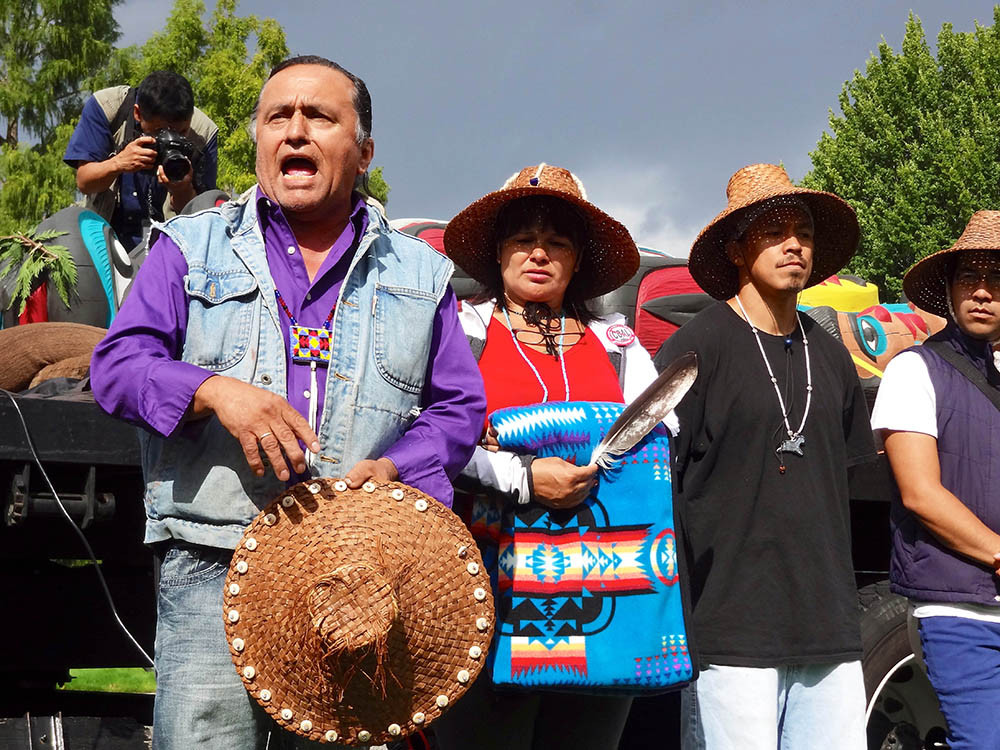
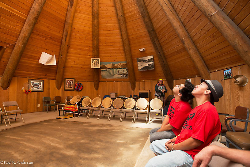
Inside a ceremonial longhouse in northern Oregon last September, the sun’s rays spilling between the high-peaked beams, Davis Yellowash Washines was seated in full ceremonial dress — yellow headband, red sash, beaded shoes. A rawhide drum rested in his hand, and to his left sat four teenage boys, each with his own drum and mallet. One wore a black Chevrolet T-shirt. They thumped their instruments and called out native songs as an organized smattering of young children bounced rhythmically counter-clockwise around the dirt floor. Two dozen fellow members of the tribal community, seated in folded metal chairs, looked on.
“This longhouse is used for lots of occasions,” Washines said between songs. “But this one is significant.”
This ceremony aimed to ward off coal.
Celilo Indian Village, Ore., separated from the Columbia River by only a highway and some railroad tracks, is one of many tribal communities that sit in the path of what could soon become America’s coal-export superhighway. If government agencies grant approval to three export terminals proposed for Oregon and Washington, up to 100 million metric tons of coal per year could soon be shuttled in open rail cars from mines in the Powder River Basin of Wyoming and Montana, along the shores of the Columbia River and the Puget Sound, and through ranches and reservations like this one. The coal would then be loaded onto ships destined for Asia’s proliferating fleet of coal-fired power plants.
Many activists currently fighting the plan see the impacts of burning coal on the global climate as their primary motivation. But for the Yakama, Lummi and other tribes, as well as communities in the path of these shipments, it’s the local effects that worry them most. There are the potential traffic delays and disturbances to cultural sites. Then there’s the very real prospect of toxic coal dust wafting off the passing trains, fouling the air, poisoning local waterways and even contaminating key food resources — such as the salmon on which many local tribes, including those living in the tiny Celilo Indian Village, depend.
While the U.S. has seen a steady decline in coal use in recent years thanks to tighter federal regulations and the expanded viability of natural gas and renewable energy, the rise of burgeoning, coal-hungry economies in China, India and other fast-developing nations means the Celilo tribes — like many communities across the Pacific Northwest — now find themselves wedged squarely between a domestic abundance of the combustible rock and its most promising international market.
The potential expansion of coal exports elicits differing opinions among tribes and communities here. What may be an environmental or public health imposition for one is seen as a desperately needed opportunity for another. The coal industry, for example, argues that exports could inject welcome economic activity into struggling Northwest towns and reservations. By itself, the Gateway Pacific Terminal proposed at Cherry Point on the Puget Sound would add approximately 1,250 permanent jobs, including induced jobs such as restaurant and healthcare workers, as well as 4,400 temporary construction jobs, according to an analysis by an industry consultant. Annual local and state tax revenues would amount to about $11 million.
The dispute over the coal trains is playing out in television advertisements, on the streets and inside boardrooms, town halls and courthouses from Washington, D.C., to Seattle. A series of hearings and protests over the last few months have attracted thousands of people — some donning makeshift respirators, others wearing “Beyond Coal” T-shirts, and some even rappelling from a bridge over the Columbia River as a symbolic blockade to the shipments. Still, nowhere are the tensions so acute as on the hardscrabble reservations that either sit atop valuable coal — an estimated 30 percent of U.S. coal reserves west of the Mississippi are located on native lands — or lie in the path of the trains that would haul it to port.
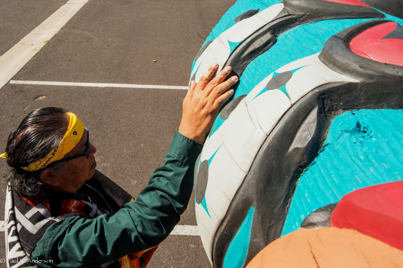
Just outside the walls of the longhouse where Washines and his fellow drummers were singing out in opposition to the coal shipments, a 22-foot totem pole lay on the bed of a white truck. The carving, which depicted five salmon, two kneeling men and a hungry child, was touring towns, churches and reservations across the Pacific Northwest as part of an effort to consolidate tribal opposition to the proposed coal shipments. (The totem’s last stop, in late September, would be across the border in the Tsleil-Waututh Nation of British Columbia, where it now stands erected as a display of solidarity with that tribe’s parallel struggle over a tar sands oil pipeline.)
“Mother Earth doesn’t have a voice,” said Karen Jim Whitford, a tribal elder, as she stepped shoeless into the center of the longhouse floor. A couple of her tears disappeared into the dirt. “So we must speak for her.”
“I vote we stand up,” exclaimed another elder, Lorintha Umtuch, referring to the totem’s symbolic call for Native Americans to get off their knees and “Warrior Up!” for future generations. “Indian people need to stop this, or else corporations will trample us.”
Not all tribes stand on the same side of the coal-export battle line. CJ Stewart, a senator of the Crow Nation, said in a phone interview in October that his tribe desperately needs to develop its coal reserves to improve its economic fortunes and lift its people out of poverty. In November, the Crow Nation signed a joint resolution with the Navajo Nation in support of each other’s coal development. “We rely on coal just as they rely on salmon,” Stewart said, referring to the Yakama and other tribes represented in Celilo. “All tribes share one common enemy, and that enemy is poverty.”
Many tribes along the rail corridor, however, feel it’s not just livelihoods at stake — it’s lives. Jewell Praying Wolf James, the carver of the well-traveled totem and member of the Lummi Nation, expressed sympathy with the coal-dependent tribes during a later stop on the totem’s journey in Olympia, Wash. “We feel bad for the Crow Nation, the Navajo, the Hopi. That’s all they got,” he said. “But we want clean air, clean water. We want salmon restored and our children healthy.”
Davis Yellowash Washines presses his hand against one of the brightly painted salmon encircling the bottom of the totem. “The salmon gave its life for you, just like the tree gave its life for this purpose,” he said. (Paul Anderson)
Dig into Native American history and you will strike coal. As far back as the 1300s, Hopi Indians in what is now the U.S. Southwest used the fossil fuel for cooking, heating and baking clay pottery. In the 1800s, Native Americans made up much of the early mining workforce that would help ignite coal’s long reign as the go-to fuel source for the country’s necessities and luxuries — from transporting goods and running factories to heating homes and powering Playstations.
But King Coal’s grip is slipping. The rise of hydro-fracturing technology in recent years has unleashed torrents of natural gas, a cheaper and cleaner alternative, and left coal-rich states and undiversified coal companies with a serious revenue problem. Many have responded by looking to Asia, where mining local coal, in addition to building wind farms and solar panels, has not created nearly enough energy for the rapidly growing economies there.
Asia’s ready market and America’s still plentiful coal could make a convenient marriage. Proving particularly attractive to Asian buyers is Powder River Basin coal, which is cheap to extract and relatively low in polluting sulfur. Yet plenty of obstacles remain in the U.S. and abroad before coal interests can successfully drive their product to northwestern ports for export. There are the vocal environmental advocates, the newly elected local leaders who’ve made clear their opposition to the plans, the big-money investors who’ve withdrawn support for port builders and, of course, the tribes.
In a July letter to the Army Corps of Engineers, the federal agency tasked with evaluating the two Washington State coal port projects, the Lummi Nation wrote of its “unconditional and unequivocal opposition” to the terminal planned for Cherry Point, near its reservation. The tribe cited among other concerns “significant and unavoidable impacts and damage” to treaty rights reserved in the 19th century to fish at its “usual and accustomed” areas.
Patricia Graesser, a spokeswoman with the Corps, acknowledged the Lummi letter and said her agency was in government-to-government discussions with the tribe. “We have a responsibility to uphold the nation’s treaty with Native American tribes,” she said.
The Chinese government, meanwhile, is responding to a major air pollution crisis sparked largely by rapid development centered on coal-fired power. In December, Shanghai’s air quality fell to a record low and the country’s smog could be seen from space. But even with leaders in China vowing to slow down the growth of coal use, experts predict global coal consumption will jump up another 25 percent by the end of the decade.
Decisions on the Northwest export terminals could significantly influence the future of coal in Asia. “Opening up this main line of cheap American coal is a pretty important signal if you are a Chinese official thinking about how much to invest in what kind of energy infrastructure,” said KC Golden, senior policy adviser for the non-profit Climate Solutions, which has advocated against the proposed ports.
The effects would span the globe. According to estimates by the Sightline Institute, a nonprofit think tank based in Seattle, Pacific Northwest coal exports could create greater national and worldwide environmental impacts, including on climate change, than a Canadian company’s controversial proposal to ferry Albertan tar sands to the U.S. Gulf Coast via the Keystone XL pipeline.
As Jewell Praying Wolf James put it: “Once the coal gets to China, it’s pollution for all of us.”
For more than 11,000 years, Celilo Falls served as the center of trade and commerce for Native Americans of the West. The upwards of 15 million salmon that passed through the mile-long span of rocky chutes in the Columbia River every year functioned as a sort of currency. “Some tribal people call it pre-contact Wall Street,” said Charles Hudson, intergovernmental affairs director with the Columbia River Inter-Tribal Fish Commission in Portland, Ore.
Lewis and Clark called it “the great mart.”
But within a few short hours on March 10, 1957, Celilo’s era of plenty came to an abrupt end. Rising floodwaters from a newly completed hydroelectric dam engulfed the rapids. Salmon runs soon shrank to a small fraction of their former numbers.
Davis Yellowash Washines, chief of enforcement for the Columbia River Inter-Tribal Fish Commission, was only 5 years old when the Dalles Dam opened and drowned Celilo Falls. “I can still feel its mist. I can still hear its thunder,” he said over dinner the night before the September longhouse ceremony.
Warren Spencer, a Yakama elder, was serving in the military in Germany that year, but he recalled the time-lapse photos of the inundation he received by mail from his mother back home in Celilo Falls. “I sat there on my bunk and cried,” he said.
Now, Spencer is deeply concerned about how this new energy project might affect the futures of his four children, 17 grandchildren and eight great-grandchildren. The coal push, he said, represents the continued encroachment of the federal government and “white man’s money” on Native American tribes. “It’s turning brother against brother,” he said.
Members of the Lummi Nation bask in the natural light of the Celilo longhouse before the totem pole ceremony in September. (Paul Anderson)
Many of the current and former residents of Celilo belong to the Yakama Nation. Like the Lummi, the tribe put its opposition to the exports on paper. In a November letter to the Army Corps of Engineers and a state official, Yakama chairman Harry Smiskin referenced a “long history of Treaty violations from energy development in the region that permanently and irreparably have harmed my People.” The new energy projects, he said, would add “direct adverse impacts” to the tribe’s treaty rights to fish, hunt and gather food, and do more damage to the already fragile environment, culture and health of his nation.
Dr. Frank James, of the University of Washington School of Public Health, underscored the “disproportionate impacts” of the coal projects facing native people of the Northwest. Much of this vulnerability results, he said, from their traditional dependence on the salmon of the region’s rivers and coastal waters — fish that are now widely listed as threatened or endangered under federal law and could be further spoiled by air and water pollution from mining and transporting the coal, and its burning overseas.
The tribes’ reliance on salmon goes beyond a staple food and a means to make a living. “It is their total way of life,” said James. “Salmon is part of their religion, their culture, their language. To further impact that is an assault on their very existence.”
In a back corner of the Celilo longhouse kitchen, Gloria Jim sat in a folding chair, on a brief break from cooking the ceremony’s Columbia River salmon lunch with other Celilo women. She lamented that they hadn’t had enough salmon to serve for breakfast, too.
“That’s how it used to be here,” said Jim, who wore a white shirt printed with a picture of her deceased son, pink stretch pants and running shoes. She recalled the Forest Gump-like menu of her childhood: Salmon, fried or dried, stuffed or baked, or simply salted.
“My mom didn’t believe in food stamps. We lived on what we caught,” she said. “Now we have no choice. We have to go to the grocery store.”
Her people have been warned, she added, that the salmon they do catch and eat may be dangerously polluted. An estimated 17 percent of pregnant Native American women already have mercury levels high enough to disrupt the healthy development of their babies — much higher than other racial groups.
Deposits of the neurotoxic heavy metal, along with arsenic and other contaminants from coal-fired power plants, can accumulate up the food chain and into salmon. Research further suggests that around 25 percent of the mercury in Northwest American waterways and up to 10 percent of the ozone in the region’s skies is carried by wind currents across the Pacific — from power plants in Asia.
Coal exports could pollute the region in other ways. Perhaps most talked about are the risks of heavy metal-laden coal dust and diesel exhaust blown and belched from trains, terminals and ocean-going tankers. Derailments, such as the one that sent seven cars spilling coal into a British Columbia creek last week, raise further fears, as does the possibility of bunker fuel spills once tankers set out to sea through narrow, rough passages.
In November, Dan Jaffe, an environmental scientist at the University of Washington-Bothell, released preliminary results of a study on the environmental insults of existing coal train traffic. His team monitored 450 passing trains — some carrying coal, some not — from two representative sites. They sampled for about 10 days at a spot on the Columbia River Gorge and for about a month near a Seattle home that butts up against railroad tracks currently used by trains en route to Canadian coal ports. Jaffe said he confirmed elevated levels of diesel exhaust there “on par with the dirtiest air in the Seattle area,” as well as a slight increase in large airborne particles — likely coal dust, he said — when coal trains passed by.
The three proposed terminals would dramatically increase rail traffic, bringing some 35 additional mile-plus-long trains in and out of the region every day. Currently, fewer than 10 coal trains come and go.
Jaffe’s crowdfunded research has yet to be peer-reviewed, a point emphasized by Courtney Wallace, a spokeswoman with Burlington Northern Santa Fe Railway, whose lines would host much of the westbound coal. Wallace added that BNSF has spent more than $1 billion on rail cars and locomotives that “achieve the highest EPA standards available,” and result in 69 percent fewer diesel emissions compared to older locomotives.
BNSF has testified that up to 645 pounds of coal dust can escape from each rail car during a 400-mile journey, but Wallace also pointed to findings by the railway that this fugitive dust diminishes as railcars travel farther from the Powder River Basin and toward export terminals.
Several environmental organizations, including the Sierra Club, filed a lawsuit in July against BNSF over coal contamination of U.S. waterways. Wallace called the action a “publicity stunt,” but a U.S. District judge denied a motion to dismiss the case this month.
Blown coal dust and other hazards could be particularly dire around Celilo and the rest of the Columbia River Gorge, where train tracks are sometimes just feet from tribal residences, said Hudson, of the Columbia River Inter-Tribal Fish Commission. “The winds are reliable and strong — 40, 50, 70 miles per hour,” he said. “There’s a reason it’s the wind-surfing capital of the world.”
Located in rural Montana, the Crow Nation can’t boast a lucrative seafood or wind-surfing tourism market. What they do have is a whole lot of coal. Approximately 9 billion tons of the fossil fuel lie beneath their land, comprising one of the largest coal reserves in the United States.
“Coal is the way we’ve been taking care of our people,” said CJ Stewart, the Crow senator. Yet his people continue to struggle with poverty and an unemployment rate he suggested is upwards of 50 percent. “And the U.S. cries over its 8 percent,” he said.
In June, the U.S. government approved a deal between the Crow and Cloud Peak Energy, a Wyoming company that’s moving to increase its coal exports to Asian markets. The tribe now has the green light to lease its rights to an estimated 1.4 billion tons of coal, more than the U.S. consumes annually. The deal could be worth at least $10 million for the Crow over the first five years. Cloud Peak has also pledged to give preference in hiring, training and promotion to qualified Native Americans, as well as annual scholarships to local native students. A spokesman for Cloud Peak, Rick Curtsinger, said the company is continuing to work through an agreement with the tribe.
Crow Nation chairman Darrin Old Coyote testified in July before the U.S. House Committee on Natural Resources that the deal is largely dependent on the fate of coal exports through the Northwest. Such significant coal development, he said, has “unlimited potential to improve the ongoing substandard socioeconomic conditions of the Crow people and the surrounding communities in southeastern Montana.”
“Given our vast mineral resources, the Crow Nation can, and should, be self-sufficient,” he said.
Also in the heart of the Powder River Basin, and also saddled with high unemployment, are the Northern Cheyenne. The tribe has a long history of resisting coal development due to perceived environmental health risks. But like the Crow, the Northern Cheyenne are also recognizing an increasingly tough economic reality.
“We’ve got a lot of coal underneath our land,” said Tom Mexican Cheyenne, director of the Northern Cheyenne’s community health department, who made clear that he did not speak for the tribe. “There’s a split — some on the tribal council are for coal mining and some are against it.”
The Northern Cheyenne’s decision on whether or not to harvest their coal may, too, come down to pending verdicts on the Pacific Northwest ports. No train tracks currently run to their reservation’s coal reserves, though rail lines could be expanded with enough demand.
Mexican Cheyenne believes the council is leaning towards development of the coal. “I see a real desperation to help the economy any way they can,” he said.
Wind energy has also been on the table here for years. But impoverished tribes such as the Northern Cheyenne and the Crow often lack the funds necessary for capital investments and opportunities for outside help, such as tax credits.
Debra Lekanoff, a leader with the Swinomish Tribe of Washington, said the tribes need federal support to find alternative ways to benefit from their resources. “We urge the federal government to help our brothers and sisters with funding, capacity-building and sound science to open up the doors to new opportunities,” she said.
She suggested that the “elephant in the room” in the coal development debate is the challenge of “walking in two worlds” and soundly balancing “economic sustainability and environmental protection.”
The Affiliated Tribes of Northwest Indians, which includes the Yakama and Lummi, adopted a resolution in September supporting a pilot project proposed by the Crow Nation to convert some of its coal to liquid fuels such as diesel and gasoline for domestic use. The tribe’s plan, which Stewart said illustrates that the Crow are not entirely reliant on coal exports, also gained support from the National Congress of American Indians this fall. It still awaits federal approval.
The official document from the Northwest Indians, however, notes that their blessing does not “supersede, replace, or rescind” a resolution made by the group in May that opposed all proposals to increase transportation through the region of “fossil energy,” including both coal and unrefined crude oil.
About a week after the resolution’s adoption, Jewell Praying Wolf James’s totem pole pulled up in front of the Washington state capitol building in Olympia for another event opposing coal exports. Much like the other stops on the totem’s journey, this ceremony’s songs and speeches pointed to both the despair and hopes of Native Americans and the deeply complex tensions at hand.
A crowd of some 50 people, many representatives of local tribes, stood in the alternating rain and sun in front of the flatbed truck. Flanking the truck was a yard sign that read, “No coal exports. We can do better.”
Creating alternatives, experts agree, is prerequisite to combating climate change and sustaining resources for future generations — and even to passing judgment on any group that chooses to develop its coal, or buy and burn it.
“At the end of the day, we’re not going to stop fossil-fuel dependency if we don’t have an answer for how to create energy and create better lives,” said KC Golden, the Climate Solutions policy adviser. “The Crow and other folks across the world want a fair shot at the relative prosperity we enjoy. We have to have a better answer than digging up half of Montana and burning it in Asia.”
Today’s casinos of flashing lights and slot machines in smoke-filled rooms attract high rollers and bad losers. Many see casinos as a lucrative business for Native American reservations — but does this myth of money-making match reality?
Twenty-five percent of the U.S. population aged 21 and over visited a casino and participated in gambling in 2010. In that year alone, U.S. casinos enjoyed revenues of $34.6 billion, according to the American Gaming Association.
It’s a common assumption that the gaming industry is a cash cow for Native Americans, especially since the U.S. Supreme Court ruled in 1976 that as part of tribal sovereignty, state tax and regulatory laws do not necessarily apply to Native Americans living on reservations.
Tribal sovereignty refers to tribes’ right to govern themselves, define their own membership, manage property, and regulate tribal business and relations while recognizing a government-to-government relationship with states and the federal government. But despite tribes’ independence and exemptions, the Native American population as a whole comprises the minority living with the largest disparities in health, education and income in the United States.
The unemployment rate on some reservations can reach as high as 75 percent, with nearly 10 percent of all Native families being homeless. For some of those families who do have homes, they may lack electricity or running water, Liberation news reports.
Gaming has helped raise tribal communities out of poverty by providing funds for housing, schools, health care and education, as well as stable jobs for community members, but according to the Native American Rights Fund, of the estimated 560 federally recognized American Indian nations, only 224 are involved in gaming. Tribes who are geographically located on rural, unpopulated land may never take part in the industry, while those who reside near major urban areas benefit the most from gaming operations.
Can tribal sovereignty exist within a city?
The Fond du Lac Band of Lake Superior Chippewa not only has a casino on its reservation in northern Minnesota, but one that is located 20 miles to the east in downtown Duluth. With the “Fond-du-Luth” casino establishment located outside of the reservation, issues pertaining to tribal sovereignty and gaming revenues are currently being disputed by city leaders.
The Minneapolis Star Tribune reports that because Fond-du-Luth is outside the reservation, a 1994 agreement was enacted, stating that the casino would pay a 19 percent “rent” of its gross income for 25 years and an unspecified rate for the following 25 years to the city in exchange for services. This provided Duluth with around $6 million income annually from the Fond du Lac band, but in 2009, the band stopped paying.
Karen Diver, chairwoman of the Fond du Lac band, said payments were halted when it began questioning the legality of the agreement. After asking the National Indian Gaming Commission to review the 1994 consent agreement, it found the agreement violated the Indian Gaming Regulatory Act, which requires tribes to have “sole proprietary interest” for tribal casinos.
The band negotiated a payment-per-services model, covering services like law enforcement and fire protection, but a U.S. District Court judge ruled this month that $10.4 million is owed from the Fond du Lac band’s halted payments from 2009 to 2011, which the band might be able to appeal.
The issues that arose in Duluth were similar to those when New York Gov. Andrew Cuomo (D) was onboard for a plan to build casinos under the Seneca Nation in Rochester and other areas upstate.
Initially, like Fond-du-Luth, there was discussion of the state government receiving a negotiated piece of the casino’s gross intake, but the sovereignty issue again posed question.
“How could you put a sovereign nation in the middle of your downtown?” said Lovely Warren, Rochester city council president.
Steve Siegel, formerly of the College of Hospitality and Tourism Management at Niagara University, told Rochester City Newspaper that most of the time, when a tax-exempt casino is placed on what is claimed to be sovereign land within an urban setting, all of the gain goes to the casino complex.
“Local businesses are devastated because they can’t compete with this massive nontaxable entity,” Siegel said.
Native Americans are still Americans
Although the casino institutions themselves are not federally taxed, in 2006 the IRS issued a bulletin stating that individual Native Americans, especially those living outside of a reservation, are still subject to federal income tax every year.
More than seven in ten Native Americans and Alaska Natives now live in metropolitan areas, and 27 percent live in poverty, according to the Census Bureau.
The bulletin states:
“While there are numerous valid treaties between various Federally Recognized Indian Tribal Governments and the United States government, some of which may contain language providing for narrowly defined tax exemptions, these treaties have limited application to specific tribes … Taxpayers who are affected by such treaty language must be a member of a particular tribe having a treaty and must cite that specific treaty in claiming any exemption. There is no general treaty that is applicable to all Native Americans.”
Even so, many Native American families subject to treaties are still not exempt from taxes. The IGRA has provisions that permit tribes to make per-capita distributions from gaming activities to tribe members and the community. But according to the bulletin, “Under the Indian Gaming Regulatory Act, any distribution of casino gaming proceeds to individual tribe members is also subject to federal income tax.”
Essentially, Native Americans are living in a nation where the majority of its population is struggling to make ends meet. They face taxes and economic strife while trying to support their families. Some may sit more comfortably than others, but the late-night hours from visitors at the slot machines or blackjack tables don’t quite live up to the dream.
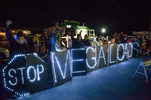
Lawsuit questions whether transport is more good than harm
By George Plaven, East Oregonian
PENDLETON, Ore. — A third and final shipment of massive oil refinery equipment is bound for Canada after departing the Port of Umatilla earlier this week. But while the convoy lumbers south on Highway 395, opponents representing environmental and tribal concerns filed a petition in Marion County Circuit Court that would keep future loads off the road without increased public input.
Petitioners Peter Goodman, with the nonprofit organization Act on Climate, and Carl Sampson, headman-chief of the Walla Walla Tribe, allege the Oregon Department of Transportation didn’t properly consider public interest when permitting the loads hauled by Hillsboro trucking company Omega Morgan.
State law allows ODOT to issue variance permits for oversize loads “if it determines the public interests will be served.” Yet the department declined to hold public hearings, provide notice or allow any opportunity for comments, according to the petition.
If the petitioners succeed, a judge would order ODOT to set aside permits for megaloads until determining actual public interest. Goodman and Sampson are also asking for a permanent injunction against new variance permits until the department establishes rules for public involvement.
Patrick Cooney, ODOT communications director, did not discuss litigation but said the agency issues 100,000 permits every year. In broad terms, public interest is served by allowing movement of freight and commerce across the state, he said.
“We do that in such a manner that there’s no damage caused to the system by oversize loads,” Cooney said.
The petitioners, however, claim it is not enough to find something in the public interest by only examining potential damage to highways. It requires that, overall, more good than harm is done as a result of the loads.
Megaloads will eventually supply the tar sands of Alberta, Canada with machinery necessary to extract and ship oil, Goodman said, leading to global climate change.
“The cargo is so damaging to the environment,” he said. “The end result for climate change is really disastrous.”
At approximately 400 feet long, 22 feet wide and weighing more than 900,000 pounds, the megaloads take up both lanes on two-lane highways and are too big to fit under interstate bridges. The route being used now instead runs indirectly south into the John Day Valley and east toward Homedale, Idaho, before cutting back north through Montana and into Canada.
The loads travel approximately 35 mph, and are not permitted to drive in hazardous weather. Numerous delays have already slowed the first two shipments, which Omega Morgan began moving in December.
Protesters also held several demonstrations throughout the region, resulting in some arrests.
In addition to increased carbon emissions from tar sands oil, members of the Confederated Tribes of the Umatilla Indian Reservation oppose megaloads on their ceded territory.
Sampson — known ceremonially in the Walla Walla Tribe as Peo Peo Mox Mox, or Chief Yellowbird — asked how decades of government-to-government relations can simply be ignored to accommodate these loads in his affidavit to the court.
“Help me understand why we, the people of this land, have not had voice on such an important matter,” Sampson said. “The simple passage of these loads alone is an affront to the traditional values and ecological integrity of the lands I have been stood up by my people to protect. We have a strong tribal culture that will suffer irreparable damage if the megaload is not stopped.”
Omega Morgan project manager Erik Zander has said there is no plan to use the route as a long-term industrial corridor through Oregon. Goodman said they remain concerned about the possibility, especially as oil sands deposits are developed in Utah.
That’s why the public needs a voice in the ODOT permitting process, he said.
“We feel the citizens of Oregon should have a say,” Goodman said. “It is not worth risking planetary climate chaos for profit for relatively few people.”
_ Read more on eastoregonian.com. Contact George Plaven at gplaven@eastoregonian.com or 541-564-4547.
Brandon Jones with a rebound for Tulalip. This led to a 3 point shot, maintaining their lead. Andrew Gobin/Tulalip News
With a narrow 5 point lead throughout the game, the Tulalip Heritage Hawks faced their longtime rivals, the Lummi Blackhawks, at the District One 1B Championship game, winning 69-63, advancing to the tri-district championships playing their first game Tuesday, February 18th. This is the second Championship win for Tulalip.
FLAGSTAFF, Ariz. — The Navajo Nation president has vetoed a proposal to impose an additional tax on chips, cookies and sweetened beverages on the country’s largest reservation, but the legislation could be resurrected later.
President Ben Shelly supports the idea of a junk food tax as a way to combat high rates of diabetes and obesity among tribal members and encourage healthy lifestyles, his adviser Deswood Tome said Wednesday. But Shelly said the legislation isn’t clear on how the tax on snacks high in fat, sugar and salt would be enforced and regulated, according to Tome.
“There are a lot of supporters out there for the tax, and again, the president wants a plan that works,” Tome said. “He’s asking the (Tribal) Council to take back this initiative and redo it so that the burden is not on the government to implement a law that is going to create hardship, especially in the collection of taxes.”
The Dine Community Advocacy Alliance and tribal lawmakers had been positioning the Navajo Nation to become the leader in Indian Country when it comes to using the tax system to press tribal members to make healthier choices.
School districts across the country have banned junk food from vending machines. Cities and states have used taxes and other financial incentives to encourage healthy choices, according to the National Conference of State Legislatures, but not all the efforts have been met with overwhelming support.
The legislation in the Navajo Nation Council did not have a smooth ride either.
Denisa Livingston of the Dine Community Advocacy Alliance said the group worked for two years to get tribal lawmakers to pass the legislation. Dine is the Navajo word for “the people.”
Livingston said American Indians are more likely to suffer from diabetes and other chronic health problems than the average American.
She estimated that imposing an additional 2 percent tax on junk food sold on the Navajo reservation would result in at least $1 million a year in revenue that could go toward wellness centers, community parks, walking trails and picnic grounds in tribal communities. The tax would have expired at the end of 2018.
“Every one of our Navajo families has someone who is suffering from chronic disease,” she said. “This is the initiative we wanted to take because we see our families suffering.”
About 14 percent of the people in the area of the Navajo Nation have been diagnosed with diabetes, according to the federal Indian Health Service.
American Indian and Alaska Native adults are twice as likely to be diagnosed with diabetes as non-Hispanic whites, and Native children ages 10 to 19 are nine times as likely to be diagnosed with type 2 diabetes, the agency said.
Opponents of the tax in Navajo communities in Arizona, New Mexico and Utah argued it would burden consumers and drive revenue off the reservation.
Shelly also vetoed a companion bill to eliminate the tribe’s 5 percent sales tax on nuts, fresh fruits and vegetables. Tome said Shelly would like lawmakers to revise the legislation to address his concerns.
The Tribal Council can override Shelly’s vetoes with a two-thirds vote of its 24 members. Livingston said she would pursue that option with lawmakers.
Read more here: http://www.theolympian.com/2014/02/12/2981159/navajo-nation-president-blocks.html#storylink=cpy
PINE RIDGE INDIAN RESERVATION — The fierce winter of 2014 continues to bring record cold spells across the Great Plains. American Indian across South Dakota have been particularly hit hard with lack of propane gas and propane prices almost double from what they were last year at this time.
One Spirit, a non-profit organization that assists with fuel for low-income homeowners, reports people are burning clothes to stay warm, 20 or more people at a time in one room using an electric heater, and families who have been out of propane for days and not able to have hot food or drinks.
This is a gentleman whose wood was delivered recently. He lives in a small trailer, no indoor plumbing, no running water. He is unable to use his left arm. But tonight he is warm.
One Spirit is delivering wood as fast as possible to prevent people from having to burn clothes to stay warm.
However, not all homes on the Pine Ridge Indian Reservation are equipped for wood-burning. In those cases, propane is typically the much needed heating fuel.
One Spirit is attempting to match as many families as possible for a minimum $200 purchase of propane. One Spirit is also providing help with conservation measures to make the heat go as far as possible.
With single-digits temperatures and even below zero temperatures still in the weather forecast, One Spirit is seeking financial assistance so that tribal members can be provided with propane fuel and wood. Every dollar the public donates will be used to provide heat during this brutally cold winter.
Donations can be made by check or money order, made payable to:
VALE—With the last of three Omega Morgan megaloads poised at the Port of Umatilla, waiting out winter weather before beginning its crawl across the state, several agencies have filed a court action seeking to halt it.
Peo Peo Mox Mox Chief — Headman of the Walla Walla Tribe Carl Sampson and ActOnClimate’s Peter Goodman filed a “petition for review of agency decision” Tuesday, alleging that the Oregon Department of Transportation failed to meet what they say is a legal obligation to determine whether the permit it issued last week for the megaload’s travel “serves the public interest.”
“The position of Sampson and Goodman is that these megaloads are not ordinary vehicles to be permitted on Oregon scenic highways using routine practices established for normal oversize loads, but that they are extraordinarily large industrial loads (longer than a football field and weighing up to 900,000 pounds), causing substantial harm to the citizens of Oregon and therefore not in the public interest,” reads a press release describing the action. “At the very least, they argue, ODOT should not be making a unilateral decision without a process for hearing public comments on whether these megaloads are in the ‘Public Interests.’”
ODOT spokesman Tom Strandberg said he sent out news releases about the megaloads, and ODOT visited the Umatilla Tribe. But he said he was not sure what else was done as far as outreach. He said public hearings are not part of the permitting process. But according to Monte Grove, ODOT’s Region 5 manager, ODOT is rethinking its process for public involvement in regards to permitting megaloads because they are getting bigger and bigger.
“And now here we are, in the middle of winter, with no formal notification, no Tribal consultation, no information to our Tribal members at our monthly council meetings that not one, but three monster megaloads are coming onto our ceded boundary lands,” Sampson wrote in a statement.
“Why did the Oregon Department of Transportation allow a variance permit of such magnitude on our sovereign and inherent Treaty rights, allowing interruption into our ceremonial, cultural, social and spiritual homelands without regard to the importance to our people?”
Omega Morgan adjusted its shipping route last year after a court ruling prohibited the Hillsboro-based shipping company from using Idaho’s Wild and Scenic River Corridor for megaload transport. Its circuitous route takes it from Umatilla to Pendleton, south on U.S. Highway 395 to Mount Vernon and east on U.S. 26 to Vale where it turns onto Clark Boulevard. It proceeds south to Highway 201 into Idaho near Homedale, then through Montana and into Canada, where its loads are bound for the tar sands oil fields in Alberta.
Christina Marfice is a news reporter at The Argus Observer. She can be reached at (541) 823-4822 or by emailing christinam@argusobserver.com. To comment on this story, go to www.argusobserver.com.