The Puyallup Tribe of Indians is building a library of genetic material from coho salmon to better understand the different populations throughout the Puyallup River watershed.
“The data behind how all these fish are related can give us a pretty clear picture of how many populations are actually here,” said Russ Ladley, resource protection manager for the tribe. “Are populations that have different run timings independent of each other, or do they interbreed?”
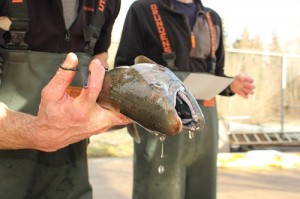
A winter coho is sampled for genetic material on the White River, a tributary of the Puyallup.
Winter run coho migrate through the Puyallup as late as February or even March while the earliest run fish are often seen as soon as July. “There isn’t much time when coho aren’t moving into the freshwater to spawn,” Ladley said.
“I would like to collect an adequate sample so we have a background from which to compare,” Ladley said. “I want to know, for example, if the late time coho we see in the White River are different from early coho we see there.”
“Thirty years ago the state Department of Fish and Wildlife sprinkle planted coho fry throughout the watershed, so I would like to find out if the fish are all the same or are still diverse,” he said.
Much of the Puyallup coho’s historic habitat has been degraded in the past century and is still disappearing, making an analysis of interrelationships vital. Coho salmon spend an extra year in freshwater as juveniles compared to other salmon species, making them more vulnerable to declines in freshwater habitat.
For example, low summer flows have been dropping throughout the watershed for decades. “Coho are their most vulnerable when we get to summer low flows,” Ladley said. “Despite a prohibition of new water withdrawals, we’ve seen a continual decline in summer flows because of unregulated wells being allowed to spread across the watershed.”
Low flows reduce the amount of habitat available for coho rearing and can cut fish off completely from valuable habitat. “When it comes down to it, fish need water to survive,” Ladley said.
“Currently, we see a fairly broad range of return timing and coho utilizing habitat from near sea level to 3,000 feet of elevation in Mount Rainier National Park,” Ladley said. “It will be interesting to learn if this is one homogenous stock or whether clear genetic differences exist.”
“This genetic data will give us a clearer picture of exactly how diverse they are, and hopefully give us information we can use to better manage the stock,” he said.
More information on the decline in salmon habitat in the Puyallup River watershed can be found at: http://go.nwifc.org/puyallup and for all of western Washington, here: http://nwifc.org/publications/sow/
(END)
For more information, contact: Russ Ladley, resource protection manager, Puyallup Tribe of Indians, (253) 845-9225. Emmett O’Connell, South Sound Information Officer, NWIFC, (360) 528-4304, eoconnell@nwifc.org
Associated Press Washington Redskins owner Dan Snyder.
Indian Country Today Media Network
With a four-page letter released late in the day on Monday, Washington Redskins owner Dan Snyder has taken his stubborn defense of the team’s name to a new level.
The early reaction from Indian country: We’re not buying it.
Snyder’s letter begins by affirming that he has no intention of ever changing his team’s problematic name, referring to a letter he wrote to fans in the fall: “I wrote then–and believe even more firmly now–that our team name captures the best of who we are and who we can be, by staying true to our history and honoring the deep and enduring values our name represents.”
The Redskins owner then describes his campaign of outreach to American Indian communities, and cites facts about poverty, health, and standard of living in Native communities that everyone in Indian country is all too familiar with.
Snyder’s conclusion: Clinging to his team’s racial-slur name is a noble gesture, but isn’t enough to solve Indian country’s problems. Or as he puts it: “It’s not enough to celebrate the values and heritage of Native Americans. We must do more.”
The letter is rife with self-satisfaction and misdirection, repeatedly emphasizing all the wonderful ways the Redskins, through the Foundation, might help Indian country, with no mention of the elephant in the room: The widespread objection in Indian country to the team’s name. For instance, here’s another interesting tap dance, bolded and italicized as in the original:
“Our efforts will address the urgent challenges plaguing Indian country based on what Tribal leaders tell us they need most. We may have created this new organization, but the direction of the Foundation is truly theirs.”
Such willingness to let Indians say what is most beneficial for Indians does not, obviously, extend to his football team’s name.
The announcement has met with harsh criticism in Indian country.
“We’re glad that after a decade of owning the Washington team, Mr. Snyder finally says he is interested in Native American heritage, but this doesn’t change the fact that he needs to stand on the right side of history and change his team’s name,” Oneida Indian Nation Representative Ray Halbritter, said in a statement to ThinkProgress.
Suzan Shown Harjo, who has led the legal charge against the name for decades, shared stronger words with Think Progress: “Native America is impoverished? He just now figured that out? We know what the pressing issues are. We’re the ones who’ve been dealing with them all our lives. What an insult. The whole thing. This is a stunt. To me, it’s a stunt. But we’ll see. Supposedly it’s a change of heart, but it’s not a change of mind. And it’s not a change of name.”
Backlash on Twitter from Natives, many of whom have been united by the #NotYourMascot hashtag, has been forceful.
Frank Waln @FrankWaln “Dan Snyder is scum of the earth”
Lauren Chief Elk @ChiefElk “Countdown until ‘Dan Snyder is trying to help you and you guys aren’t even grateful!'”
Johnnie Jae @johnniejae “Apparently visiting 26 of 300+ reservations & bribing 400 tribal leaders means we should bow to our new savior Dan Snyder #notyourmascot ”
What TRIBE @WhatTRIBE “When redeeming racist brands, hire brand management experts from secret service to create pity press for penance/ not repentance @Redskins ”
Dani @xodanix3 “Whats most frustrating about Snyder’s strategies is just how petty they are. Its insulting they even take it there.”
julia good fox @goodfox “‘@Redskins: It’s not enough to celebrate the values and heritage of #Native Americans, we must do more’ <— not The Onion.”
Sarah @eyesnhearts “I’m pretty sure I don’t need the white savior industrial complex to help me with my reality #NotYourMascot ”
Adrienne K. @NativeApprops “What kind of choice is that for communities? Here, have some desperately needed resources. Shhh, just say you don’t mind the racial slur.”
Aura Bogado @aurabogado “Synder understands #Natives so well that he mentioned Redskins 24 times, and tribal sovereignty 0 times”
Jacqueline Keeler @jfkeeler “Dan Snyder, helping is not dictating. Being a friend means listening not buying silence. #NotYourMascot ”
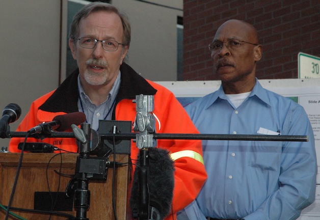
Snohomish County Public Works Director Steve Thompson, left, explains the relative stability of terrain at the Oso landslide site on March 24, as Snohomish County Executive John Lovick looks on. — image credit: Kirk Boxleitner
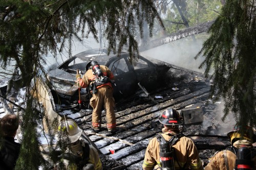
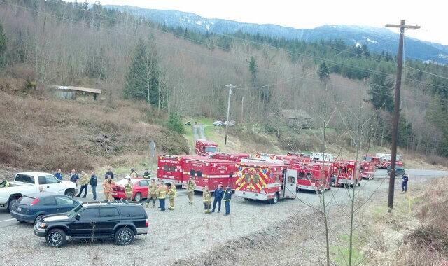
ARLINGTON — Snohomish County Executive John Lovick described Monday, March 24, as “a day of progress and sadness,” as six more were confirmed dead as a result of the Oso landslide on Saturday, March 22, bringing the disaster’s total death toll to 14, and reports of missing and unaccounted for persons in the area escalated from 108 at the start of the day to 176 by the time county officials conducted their third and final press conference of the day, outside of the Arlington Police Station.
Snohomish County Fire District 21 Chief Travis Hots reiterated that firefighters and law enforcement personnel have been joined in their efforts by search and rescue crews, search dogs and heavy equipment from the state Department of Transportation, the latter to move mud out of the way, and he added some words of appreciation to locally based responders, who have provided insights on whether certain homes were likely to have been occupied at the time of the landslide.
“Crews up there are up against enormous challenges,” Hots said. “The debris fields are like big berms of clay and quicksand. One of the folks out there told me, ‘You know, Chief, sometimes it takes five minutes to walk 40-50 feet and get our equipment over these berms.'”
Hots noted that the challenges of working in, much less walking across, such debris have been further complicated by the presence of septic tank materials, as well as gasoline, oil, propane and other contaminants.
“It’s very tedious and slow-going,” said Hots, who relayed another responder’s experiences with “void spaces,” such as houses, out in the field. “He said it’s very tough to even search those buildings, because they’ve been collapsed and compressed with all that material that’s come down. He best described it as like cement, that’s gone into those void spaces, and it’s very, very difficult to get in there and actually search. One of them even told me, ‘You know, Chief, I sat there for an hour, moving material, and only moved maybe about four buckets of material in about an hour.'”
Hots was disappointed to report that crews found neither any survivors nor any signs of survivors during the day, and Snohomish County Department of Emergency Management Director John Pennington likewise acknowledged how discouraging it must sound to hear that the number of reported missing and unaccounted for had increased by so many in a single day, but Pennington emphasized yet again that those consolidated lists of reports are not entirely synchronized yet, and could include duplicates.
“That number is about individual names reported,” Pennington said. “They’re not individuals that are deceased. They’re not individuals that are injured. They’re not individuals that are missing. They’re 176 reports.”
Pennington described the crews’ “strongly enhanced and coordinated response” as improved over their previous two days, and extended his thanks to Gov. Jay Inslee and President Barack Obama for declaring this situation an emergency on the state and federal levels, thereby facilitating assistance from the Federal Emergency Management Agency.
“They’ve dispatched us a mobile command vehicle from the Mobile Emergency Response System, otherwise known as MERS,” Pennington said. “That’s going to be dispatched out to Darrington to help them establish communications. At the same time, I’m happy to announce that we’ve established an Emergency Operations Center in Darrington, in conjunction with the town of Darrington and the Department of Emergency Management.”
According to Pennington, the federal government is finalizing the details to send a Type 1 federal search and rescue team, in addition to the Incident Management Assistance Team that’s already arrived from FEMA.
“Today, we were able to secure National Guard assistance, in the form of a 50-person search and extraction team,” Pennington said on March 24. “That team is en route here, and they will assist with our search and rescue efforts as well, with very technical expertise that we believe will be very effective in the days to come. The Northwest Incident Management Team — the local regional team from the Pacific Northwest and the northwest part of Washington state — remains on scene and continues to manage this incident, and for that, we’re eternally grateful.”
Pennington not only repeated his request, that members of the public report the names of missing or unaccounted for people to the Department of Emergency Management Call Center at 425-388-5088 if they have not done so already, but he also asked that they send in photos of those who may be missing or unaccounted for, via email at DEMCallCenter@snoco.org, and include the individuals’ first and last names, as well their distinguishing marks or features.
“There is an awful lot of grieving out there in this community,” Pennington said. “There is an awful lot of unknown. That is completely expected. No information at the Call Center can be given out, and what we’d ask of the media and the public is, especially with shelter operations, and those individuals that are in these very tight-knit, very small communities where neighbors know neighbors, and families know each other very, very well and help out, that we would respect the privacy of those individuals as they begin the extensive grieving process.”
Although Pennington acknowledged that it is increasingly unlikely that any survivors will be found at this point, he nonetheless expects crews to proceed as though they’re conducting rescue rather than recovery operations, until such time as they feel the need to stop.
Snohomish County Public Works Director Steve Thompson clarified that certain crews had been pulled out of the area between approximately noon to 1 p.m. and 2:30-3 p.m., due to concerns that the landslide might still be moving, but assessments by three geologists on site determined that there was no additional risk.
“It just turned out to be some sloughing off the edge of the slide,” Thompson said. “Some trees were falling, but nothing deep, nothing to worry about, so we gave a green light to let the rescue commence.”
“Currently, the search effort is directed where there’s most likely to still be people that may need rescuing,” Hots said, before adding that pockets of vehicles, buildings and other structures are most likely to contain any remaining survivors. “There’s other areas of the scene where it’s not probable that there’s going to be anybody, areas where there were no houses. We’re checking the areas where the two neighborhoods were, and along the road on SR 530, both from the Darrington side and the Oso side.”
While the North Fork of the Stillaguamish River is currently flowing in an orderly fashion as it carves a new channel for itself on the north end of the Oso landslide blockage, the National Weather Service’s Flash Flood Watch remains in effect through Tuesday, March 25, due to the instability of the debris dam and the materials in it, as well as the unpredictability of how the new river channel will cut through it.
Fire Crews spray foam to smother accelerants. Andrew Gobin/Tulalip News
By Andrew Gobin, Tulalip News
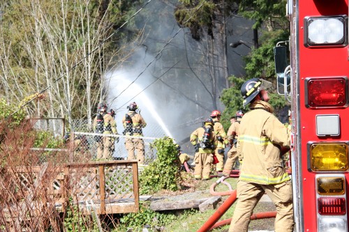
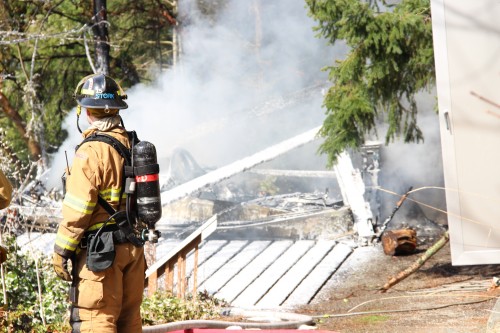
Tulalip – Tulalip Bay, Stanwood, Getchell, and North County fire departments responded to a garage fire at Sunny Shores around 12:30 this afternoon. Firecrews arrived to find the structure fully engulfed in flames.
With limited water, fire crews were able to extinguish the fire, but not until the structure was almost completely gone. Andrew Gobin/Tulalip News
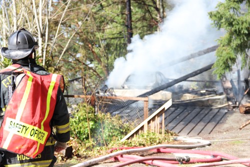
“There was nothing left of the roof, the walls were almost completely gone, the metal door had melted down, and the car was gone,” said Tulalip Bay Fire Chief Teri Dodge.
Water tenders brought water down the one-lane access road, because there are no hydrants in the area. After extinguishing the fire, crews sprayed foam on the scorched remains to prevent accelerants from reigniting the blaze.
Dodge explained, “Garage fires tend to burn very quickly. Once the fire breaches the roof or the walls, the oxygen feeds it. Most garages have accelerants inside as well, which make garage fires that much more devastating.”
In addition to limited access and limited water, there was a downed power line that crews had to work around until Snohomish County PUD was able to cut power to the line.
The garage burned completely to the ground, leaving only the floor and what remained of the vehicle inside.
Firemen test the burnt out floor to reach the remains of the vehicle. Andrew Gobin/Tulalip news
The fire was discovered by homeowner Heidi Atterson who then called 911. Her husband, Steve Atterson, arrived on scene shortly there after. The cause of the fire has yet to be determined, though it is suspected to have began as an electrical fire.
Ruins of garage fire caked with extinguishing foam. Andrew Gobin/Tulalip News
Andrew Gobin is a reporter with the See-Yaht-Sub, a publication of the Tulalip Tribes Communications Department. Email: agobin@tulaliptribes-nsn.gov Phone: (360) 716.4188
Emergency response on-scene Information Center. Photo: Washington State Patrol.
BY MYNORTHWEST.COM on March 23, 2014 @ 11:10 am (Updated: 8:45 am – 3/24/14 )
Snohomish County’s hotline about reunification, evacuations, and shelters is 425-388-5088.
Residents impacted by the mudslide near Oso are urged to register on the Red Cross website safeandwell.org to list themselves as “safe and well” or to search for other people who are already registered.
You can donate to the Red Cross, any amount is helpful. Call 1-800-RedCross or donate online. You can also text the words RedCross to 90999 and $10 will be charged to your cell phone bill.
Snohomish County says a group of volunteers is helping people affected by the slide move their livestock and pets. The volunteers are located throughout Camano Island, Stanwood, Everett, Arlington and other cities.
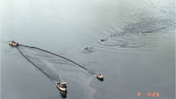
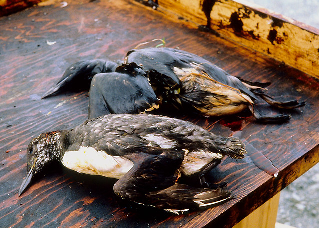
Killer whales swimming in Prince William Sound alongside boats skimming oil from the Exxon Valdez oil spill. Scientists report that orca populations there have not recovered and oil is still being found. | credit: (State of Alaska, Dan Lawn)
25 years ago today the Exxon Valdez, an oil tanker bound for Long Beach, Calif., ran aground in Prince William Sound.
11 million gallons of oil spilled out, polluting 1,300 miles of Alaska’s coastline.
At the time it was the largest oil spill in U.S. history.
Gary Shigenaka and Alan Mearns responded to the Exxon Valdez, and they’ve been studying oil spills ever since. They’re scientists with the National Oceanic and Atmospheric Administration in Seattle.
They told EarthFix’s Ashley Ahearn about their experience responding to the Exxon Valdez all those years ago.
Alan Mearns: Some places we’d go ashore and you’d see starfish that looked like they were sick, they were just kind of drifting around in the surf. And you could smell the oil too, in the places where there was plenty of it. It smelled like benzene, like you’re pumping gas at the gas station and you sniff that little bit of benzene as you pull the hose out of your car.
EarthFix: Gary, how were orcas impacted by the spill?
Gary Shigenaka: Two groups that frequent Prince William Sound crashed immediately after the spill. So since the time of the oil spill those populations have continued to be monitored and we can follow the trends and for the AB pod — the resident pod – there’s been a slow recovery. For the AT1 group, which is the transient pod, it’s been declining ever since the spill and the orca specialist for Prince William Sound, Dr. Craig Matkin, has predicted that that particular group is going to go extinct. It continues to decline with time. So it’s an unfortunate longterm legacy from the spill.
EarthFix: Some people thought the orcas would swim away, would avoid the oil spill itself, but that wasn’t actually the case, was it?
Shigenaka: What we all thought was that orcas are so smart. They will simply avoid the oiled waters. But we’ve got very good photographic evidence that shows that indeed they did not.
One photograph, an aerial photograph, shows orcas cutting through a slick and you can see where they’ve come to the surface right through the oil. There’s another shot of a pod of orcas right at the stern of the Exxon Valdez, right at the tanker.
EarthFix: What creatures were the most impacted or most harmed by the Exxon Valdez spill?
Mearns: Oh, birds. We’re talking about 200 to 300,000 I think, Gary.
Shigenaka: Yeah.
Mearns: Seabirds, mainly seabirds and some shorebirds. And of course that was the big thing you’d see in the news almost every day: pictures of an oiled bird, somebody picking it up, taking it to a wildlife rehabilitation station where they’d clean them and then hold them until they could be released.
Birds killed as a result of oil from the Exxon Valdez spill. Credit: Exxon Valdez Oil Spill Trustee Council.
EarthFix: SO for people who weren’t alive, weren’t reading the paper when the Exxon Valdez spill happened, what were those animals going through? What happens to a bird when it interacts with an oil slick?
Mearns: Well, first of all, even though it’s in the spring and summer it’s still cold up there. If it’s not killed by being smothered by gobs and gobs of oil, if it’s a little bit of oil, it will succumb eventually to things like pneumonia-type diseases and things like that, so it suddenly causes birds that had good insulation not to have insulation and start suffering the effects of cold conditions.
Shigenaka: And the same holds true for another of the iconic wildlife species in Prince William Sound: the sea otters. They insulate themselves with that nice thick fur pelt and they are affected in the same way by oil disrupting their ability to insulate themselves during a spill.
EarthFix: 25 years later, how is Prince William Sound? What species have recovered, how does the place look?
Mearns: Well, 14 or 15 species or resource values have recovered. The recovery started a few years after the spill with things like bald eagles. A number of them were killed off but their population rebounded. The most recent recovery was just announced was of the sea otters that we were just talking about. So between 1991-92 when we started seeing reports of recovery of a few bird species and now we’ve had about 14 or 15 species recover but there’s still some others that haven’t yet.
EarthFix: Which ones are you most concerned about, Alan, or scientists are following most closely with concern?
Mearns: The orcas are really the ones we’re most concerned about now.
EarthFix: Is the oil gone?
Mearns: No. There are still traces of oil in the shorelines. When you go out at low tide and go into some of these back bay areas with gravel and sand overlying bedrock and dig down maybe a foot sometimes you’ll hit spots with oil that is still actually fairly fresh. We’ve encountered that at a few sites that we’ve monitored over the past 25 years.
Shigenaka: That’s been one of the 25-year surprises for us is that there are pockets of relatively fresh oil remaining both in Prince William Sound and along the coast of the Alaska Peninsula and that’s something that I don’t think any of us expected 25 years later.
EarthFix: What did this spill mean for your careers? You guys were both young bucks when this happened. And now, 25 years later, when you look back, what did it mean, the Exxon Valdez?
Shigenaka: I think overall, just the notion that we have a responsibility, both as responders and as scientists to try to communicate what we do and what we know in a way that’s understandable to the people who are affected.
EarthFix: There is more oil moving through this region now – more oil coming from the tar sands of Alberta and coming from the Bakken oil fields of North Dakota to refineries here in Washington state. If I talk to you guys 25 years from now, what do you hope we’re talking about?
Mearns: One thing that I worry about and I think Gary has some other things that he worries about is a lot of this new oil is going to be going through the Aleutian Islands, the great circle route, more and more tankers leaving here or in Canada and heading across. And in the Aleutian Islands, we thought Prince William Sound was remote, well the Aleutian Islands are even more remote. Getting equipment there, getting staff, we’ve had a few experiences with spills. I guess I’m concerned that there will be more spills in that region from this increased traffic out there.
EarthFix: Or elsewhere.
Mearns: Yeah.
Shigenaka: 25 years from now I’m hoping that we have a much better handle on how these novel new oils like the tar sands oil and the Bakken crude oil from North Dakota, how they behave in the environment and what their potential impacts are to exposed organisms because frankly right now we don’t really know how the stuff behaves, both types of oil, once it gets loose in the environment and we’re only beginning to understand what potential impacts there might be for the exposed communities.
Gary Shigenaka and Alan Mearns are scientists with the National Oceanic and Atmospheric Administration in Seattle. They responded to the Exxon Valdez spill 25 years ago.
File photo of the fish ladder at John Day Dam on the Columbia River. The fish ladders at the Wanapum and the Rock Island dams are dry. U.S. Army Corps of Engineers
The ongoing issue with the cracked Wanapum Dam in central Washington is now creating a problem for migrating salmon.
The drawdown of water between the Wanapum and the Rock Island dams to relieve pressure on the crack means the water levels are down about 25 feet at the base of both dams.
That leaves fish ladders high and dry.
Now, government fish scientists and engineers are trying to figure out just how to get adult salmon by both hulking concrete structures. At Wanapum, engineers plan to pump water into the fish ladder and create a sort of waterslide for salmon.
Russell Langshaw, a fisheries scientist with Grant County utility district that owns and operates Wanapum, says record numbers of fish are headed that way, so they have to get it figured out by mid-April.
“We have a lot of fish coming back this year, and we agree it’s an absolute necessity that we have safe and effective passage at both Wanapum and Rock Island dams.”
Langshaw says the smaller, juvenile fish are expected to be fine. They’re going downstream, and can move through the spillways and turbines.
Langshaw also says juvenile bypass systems are still operational at the Wanapum and the downstream Priest Rapids dam to help the small fish get downriver.
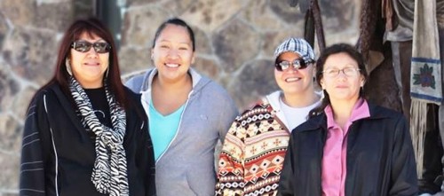
Team members of the 17 Mile Road Project included, from left, Leticia Black of the U.S. Bureau of Indian Affairs and Colette Friday, Nadine Vasquez and Wildene Trosper all of the Shoshone and Arapaho Department of Transportation. Photo provided by WyDOT
The Wyoming Department of Transportation’s 17 Mile Road Project Team will be recognized with a national award for its work on right-of-way issues during the final reconstruction on the Wind River Indian Reservation.
The American Association of State Highway and Transportation Officials will recognize this group of state and federal workers and Eastern Shoshone and Northern Arapaho tribal transportation officials with the 2014 Federal Highway Administration Excellence in Right-of-Way Leadership Honorable Mention Award.
The following individuals were recognized for their work: Kevin Lebeda of Cheyenne of WyDOT, Letitia Black of Bureau of Indian Affairs, Howard Brown of Shoshone and Arapaho DOT, Wildene Trosper of Shoshone and Arapaho DOT, Colette Friday of Shoshone and Arapaho DOT, Nadine Vasquez of Shoshone and Arapaho DOT, Nicole Brown of Shoshone and Arapaho DOT, Emily Underwood of Shoshone and Arapaho DOT.
WyDOT’s Right-of-Way Program in Cheyenne, Shoshone and Arapaho Department of Transportation, and U.S. Bureau of Indian Affairs also were honored.
“Leadership qualities were magnified by everyone on the team,” said Tim Payne of Northern Engineering and Consulting of Arapahoe, who wrote the award nomination. “In order for all right-of-way issues to be resolved, every individual at one time or another spent a remarkable amount of energy, effort, perseverance and commitment to the greater good of the team.”
Award winners will be recognized during the AASHTO Subcommittee on Right-of-Way, Utilities, and Outdoor Advertising Council Control conference April 27 to May 1 in Salt Lake City.
“The FHWA Excellence in Right-of-Way Awards recognizes outstanding innovations that enhance the right-of-way professional’s ability to meet the challenges associated with acquiring real property for federal-aid projects,” said Gloria M. Shephard, associate administrator for planning, environmental and realty with the Federal Highway Administration in Washington, D.C.
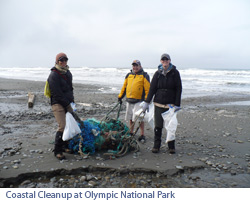
Join NPCA on April 19, 2014 as we partner with other environmental groups to remove debris from Washington beaches. Household plastics, garbage and other manmade debris are polluting our ocean, killing our marine wildlife, and spoiling our beaches and collectively we can do something about it!
This is your opportunity to be a part of the largest coastal cleanup event of the year. Last year a combined 1,000 volunteers removed over 15 tons of oceanic garbage!
We will meet at the Kalaloch Campground Saturday morning and carpool to South Beach for coastal debris removal. Olympic National Park is providing free camping at Kalaloch Campground both Friday and Saturday evenings. The event organizers, CoastSavers, will host a barbeque cookout at the campground Saturday afternoon. We encourage everyone to stay and explore the breathtaking coastlines and rainforests found in this area.
Event Details WHAT: Washington Coastal Clean-Up 2013 hosted by CoastSavers. WHEN: The clean-up is Saturday, April 19 from 9 a.m. to 3 p.m. FREE camping will be available on Friday, April 18 and Saturday, April 19! WHERE: Kalaloch Beach, Olympic National Park. Meet at the Kalaloch Campground in the main parking lot. WHO: Anyone interested–-families welcome! RSVP: Please RSVP to Shannon Brundle, sbrundle@npca.org or 206.903.1444 ext. 704, by Monday, April 14.
OTHER INFO: Remember to bring your work gloves and camping gear if you plan to camp overnight. Food is provided on Saturday at the cookout; please bring your own food and water for the rest of your stay. Also, the free camping is limited and available on a first come, first served basis– plan ahead to make sure you have a site.
Greenberg Traurig LLP
Jeffrey Leacox, Martha A. Sabol and Parke D. Terry
USA March 20 2014
Two coalitions have introduced rival bills in the California Legislature marking a third year of debate among state lawmakers over how to license and regulate on-line poker.
Previous Internet gaming legislation stalled when stakeholders could not reach consensus on the scope of games, which entities would be permitted to apply for licenses, or how licensees and subcontractors would be vetted for suitability. Also at issue in the dueling bills is the extent to which the State will attempt to impose burdens on tribal sovereign immunity in connection with any online gaming activities.
Although some differences remain, there is a sense amongst observers of the legislature that there is an emerging consensus among some stakeholders that could allow a bill to move forward. Additionally, a change in the chairmanship of one of the key legislative committees that controls gaming-related bills brings a more favorable dynamic to the discussions. The new Chair of the Senate Governmental Organization Committee, Senator Lou Correa (D-Santa Ana), is the author of one of the new bills (SB 1366) and has displayed willingness to understand and accommodate stakeholder concerns.
The Correa bill is backed by a coalition including the San Manuel Band of Serrano Mission Indians, the United Auburn Community, and the Rincon Band of Luiseño Indians, among others. The other bill (AB 2291) was introduced by Assemblymember Reggie Jones-Sawyer (D-Los Angeles), a relative newcomer to on-line gaming. AB 2291, has the support of the Pechanga Band of Luiseño Indians, the Agua Caliente Band of Cahuila Indians, and the Yocha Dehe Wintun Nation, as well as others.
Both bills legalize on-line poker only, and require that all players be physically located within the state boundaries. Both bills limit operator licensing to: (i) federally-recognized California tribes that have conducted on-premises casino gaming under the Indian Gaming Regulatory Act (IGRA) for a minimum period of time or (ii) licensed card rooms that are in good standing with the California Gambling Control Commission. Both bills provide for expedited background checks for license applicants that currently operate tribal casinos or card rooms. Both bills also exclude racetracks and advance deposit wagering providers that were included as potential licensees in previous legislation.
Significant differences between the two bills include license application procedures, eligibility and suitability requirements for licensees and subcontractors, permitted methods for presenting poker games to players, the number of websites or online gaming portals each licensee may operate, and whether the state could opt-in to any future federal framework for regulating Internet gambling.
The two bills take different approaches to the ability of licensed operators to contract with game technology, marketing, or service providers that accepted on-line wagers from players in the U.S. after December 31, 2006, the date the Unlawful Internet Gambling Enforcement Act (UIGEA) became effective. As gaming purveyors have begun to partner with providers of on-line gaming technology and marketing services, those partnerships and service arrangements have also given rise to some controversy about what sorts of entities might be excluded from participation in on-line gaming under California law has become one of the most contentious unresolved issues.
The Correa measure requires a finding of unsuitability for persons or entities that knowingly and willfully accepted a bet on any form of Internet gambling not affirmatively authorized by U.S. law, or for persons or entities that held a direct or indirect financial interest in a person or entity accepting the bet. The Correa bill further prohibits a licensee from entering into an agreement with a third party for marketing purposes that utilizes any brand or business name, trademark, software, or technology of persons or entities that knowingly and willfully accepted bets on any form of Internet gambling from persons located in the U.S. after December 31, 2006. However, the Correa bill also permits the California Gambling Control Commission to grant waivers where the person or entity demonstrates by clear and convincing evidence that it did not act in an unlawful manner.
Conversely, the Jones-Sawyer bill requires a finding of unsuitability, with no possibility of waiver, for persons or entities that accepted a wager from any person in California on any form of Internet gaming prior to an unspecified date. However, his bill does not prohibit a licensed operator from utilizing the brands, technology, or customer lists of persons or entities that would automatically be deemed unsuitable.
It is likely that both bills will be significantly amended as they work their way through the legislative process. The current legislative session is scheduled to end on August 31st and Governor Jerry Brown will have until September 30th to act on any bills reaching his desk.
With an estimated one million poker players residing within its boundaries, the Golden State would become by far the single largest Internet gaming market in the U.S. with gross poker wagers likely exceeding one billion dollars and generating potential state revenues of $250 to $400 million annually.