‘We Have a Monument!’ Islanders and Coast Salish Tribes Celebrate President Obama Establishing San Juan Islands National Monument by Proclamation

Iceberg Point Shoreline, Lopez Island. Photo by Tom Reeve.

Source: Indian Country Today Media Network

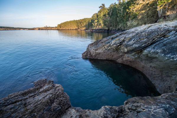
On March 25, President Obama established the San Juan Islands National Monument by proclamation. The Islands, a stunningly beautiful archipelago off the coast of Washington state and home to abundant wildlife, will now enjoy the benefits of being a National Monument. The Coast Salish peoples, for which the islands are traditional and hereditary lands, are celebrating Obama’s move.

Patos Island (photo by Linda Hudson)


According to the National Park Service, San Juan Island has been a magnet for human habitation. Its location at the crossroads of three great waterways, plus sheltered harbors, open prairie and secluded woodlands, drew people wanting to stake a life, or find rest and relaxation amid an abundant food source.

The ancestors of today’s Northern Straits Coast Salish people began to appear in the wake of the continental ice sheet that started to recede 11,000 years ago. Archaeological evidence suggests that the island supported hunting and gathering between 6,000 and 8,000 years ago. The marine culture encountered by the first Europeans to the area developed about 2,500 years ago, and traces of its once thriving villages remain in the shell middens found along the shoreline of American and English camps and throughout the San Juan Islands.


Patos Island sunset (photo by Linda Hudson


By early historic times, the indigenous people of the San Juan Islands and nearby mainland areas were primarily members of six Central Coast Salish Tribes who spoke the Northern Straits language: Sooke, Saanich, Songhee, Lummi, Samish and Semiahmoo. Another Central Coast Salish tribe that entered the Northern Straits country spoke the closely related Klallam (or Clallam) language.

In addition to sharing these languages, the Central Coast Salish tribes shared a culture and way of life through which they used a wide range of marine, riverine, and terrestrial resources. They followed patterns of seasonal movement between islands and the mainland and from large winter villages to smaller resource collection camps occupied in the other seasons. Because of the exposure to severe winter winds and storms of the Strait of Juan de Fuca, those sites found within the Cattle Point-Mount Finlayson-South Beach were considered to be more likely seasonal subsistence and resource collection and processing camps, rather than permanent settlements.

The Lummi are one of the Coast Salish peoples whose ancestors lived in the San Juan Islands.


Patos Island Lighthouse (photo by Tom Reeve)


The San Juan Islands National Monument will encompass approximately 75 Bureau of Land Management sites totaling about 1,000 acres in San Juan, Whatcom and Skagit counties. Designation as a National Monument removes these lands from possible sale or development by the Bureau and engages the local community in developing and carrying out a management plan for these lands. Under permanent protection will be dozens of small islands in the San Juans, like Indian Island near the town of Eastsound, that provide breeding grounds for birds and safe refuges for everything from harbor seal pups to rare plants.These lands include ancient fishing sites and camas gardens that are important to Native American culture, and historically important lighthouses on Patos Island and Turn Point.

Also to be protected are popular recreation destinations in the islands like Iceberg Point and Watmough Bay on Lopez Island, Patos Island and Cattle Point on San Juan Island.


Watmough Bight (photo by Steve Horn)


Here is the text of Obama’s proclamation, and visit the monument’s website: SanJuanIslandsNca.org.

Presidential Proclamation — San Juan Islands National Monument

ESTABLISHMENT OF THE SAN JUAN ISLANDS NATIONAL MONUMENT

– – – – – – –

BY THE PRESIDENT OF THE UNITED STATES OF AMERICA

A PROCLAMATION

Within Washington State’s Puget Sound lies an archipelago of over 450 islands, rocks, and pinnacles known as the San Juan Islands. These islands form an unmatched landscape of contrasts, where forests seem to spring from gray rock and distant, snow-capped peaks provide the backdrop for sandy beaches. Numerous wildlife species can be found here, thriving in the diverse habitats supported by the islands. The presence of archeological sites, historic lighthouses, and a few tight-knit communities testifies that humans have navigated this rugged landscape for thousands of years. These lands are a refuge of scientific and historic treasures and a classroom for generations of Americans.

The islands are part of the traditional territories of the Coast Salish people. Native people first used the area near the end of the last glacial period, about 12,000 years ago. However, permanent settlements were relatively uncommon until the last several hundred years. The Coast Salish people often lived in villages of wooden-plank houses and used numerous smaller sites for fishing and harvesting shellfish. In addition to collecting edible plants, and hunting various birds and mammals, native people used fire to maintain meadows of the nutritionally rich great camas. Archaeological remains of the villages, camps, and processing sites are located throughout these lands, including shell middens, reef net locations, and burial sites. Wood-working tools, such as antler wedges, along with bone barbs used for fishing hooks and projectile points, are also found on the islands. Scientists working in the San Juan Islands have uncovered a unique array of fossils and other evidence of long-vanished species. Ancient bison skeletons (10,000-12,000 years old) have been found in several areas, indicating that these islands were an historic mammal dispersal corridor. Butcher marks on some of these bones suggest that the earliest human inhabitants hunted these large animals.

The first Europeans explored the narrows of the San Juan Islands in the late 18th century, and many of their names for the islands are still in use. These early explorers led the way for 19th century European and American traders and trappers. By 1852, American settlers had established homesteads on the San Juan Islands, some of which remain today. In the late 19th century, the Federal Government built several structures to aid in maritime navigation. Two light stations and their associated buildings are located on lands administered by the

Bureau of Land Management (BLM): Patos Island Light Station (National Register of Historic Places, 1977) and Turn Point Light Station (Washington State Register of Historic Places, 1978).

The lands on Patos Island, Stuart Island, Lopez Island, and neighboring islands constitute some of the most scientifically interesting lands in the San Juan Islands. These lands contain a dramatic and unusual diversity of habitats, with forests, woodlands, grasslands, and wetlands intermixed with rocky balds, bluffs, inter-tidal areas, and sandy beaches. The stands of forests and open woodlands, some of which are several hundred years old, include a majestic assemblage of trees, such as Douglas fir, red cedar, western hemlock, Oregon maple, Garry oak, and Pacific madrone. The fire-dependent grasslands, which are also susceptible to invasive species, are home to chick lupine, historically significant great camas, brittle cactus, and the threatened golden paintbrush. Rocky balds and bluffs are home to over 200 species of moss that are extremely sensitive to disturbance and trampling. In an area with limited fresh water, two wetlands on Lopez Island and one on Patos Island are the most significant freshwater habitats in the San Juan Islands.

The diversity of habitats in the San Juan Islands is critical to supporting an equally varied collection of wildlife. Marine mammals, including orcas, seals, and porpoises, attract a regular stream of wildlife watchers. Native, terrestrial mammals include black-tail deer, river otter, mink, several bats, and the Shaw Island vole. Raptors, such as bald eagles and peregrine falcons, are commonly observed soaring above the islands. Varied seabirds and terrestrial birds can also be found here, including the threatened marbled murrelet and the recently reintroduced western bluebird. The island marble butterfly, once thought to be extinct, is currently limited to a small population in the San Juan Islands.

The protection of these lands in the San Juan Islands will maintain their historical and cultural significance and enhance their unique and varied natural and scientific resources, for the benefit of all Americans.

WHEREAS section 2 of the Act of June 8, 1906 (34 Stat. 225, 16 U.S.C. 431) (the “Antiquities Act”), authorizes the President, in his discretion, to declare by public proclamation historic landmarks, historic and prehistoric structures, and other objects of historic or scientific interest that are situated upon the lands owned or controlled by the Government of the United States to be national monuments, and to reserve as a part thereof parcels of land, the limits of which in all cases shall be confined to the smallest area compatible with the proper care and management of the objects to be protected;

WHEREAS it is in the public interest to preserve the objects of scientific and historic interest on the lands of the San Juan Islands;

NOW, THEREFORE, I, BARACK OBAMA, President of the United States of America, by the authority vested in me by section 2 of the Antiquities Act, hereby proclaim the objects identified above that are situated upon lands and interests in

lands owned or controlled by the Government of the United States to be the San Juan Islands National Monument (monument), and, for the purpose of protecting those objects, reserve as a part thereof all lands and interests in lands owned or controlled by the Government of the United States and administered by the Department of the Interior through the BLM, including all unappropriated or unreserved islands, rocks, exposed reefs, and pinnacles above mean high tide, within the boundaries described on the accompanying map, which is attached to and forms a part of this proclamation. These reserved Federal lands and interests in lands encompass approximately 970 acres, which is the smallest area compatible with the proper care and management of the objects to be protected.

All Federal lands and interests in lands within the boundaries of the monument administered by the Department of the Interior through the BLM are hereby appropriated and withdrawn from all forms of entry, location, selection, sale, leasing, or other disposition under the public land laws, including withdrawal from location, entry, and patent under the mining laws, and from disposition under all laws relating to mineral and geothermal leasing, other than by exchange that furthers the protective purposes of this proclamation.

The establishment of the monument is subject to valid existing rights. Lands and interests in lands within the monument boundaries not owned or controlled by the Government of the United States shall be reserved as a part of the monument upon acquisition of ownership or control by the Secretary of the Interior (Secretary) on behalf of the United States.

The Secretary shall manage the monument through the BLM as a unit of the National Landscape Conservation System, pursuant to applicable legal authorities, to implement the purposes of this proclamation, except that if the Secretary hereafter acquires on behalf of the United States ownership or control of any lands or interests in lands within the monument boundaries not owned or controlled by the United States, the Secretary shall determine whether such lands and interests in lands will be administered by the BLM as a unit of the National Landscape Conservation System or by another component of the Department of the Interior, consistent with applicable legal authorities.

For purposes of protecting and restoring the objects identified above, the Secretary, through the BLM, shall prepare and maintain a management plan for the monument and shall establish an advisory committee under the Federal Advisory Committee Act (5 U.S.C. App.) to provide information and advice regarding the development of such plan.

Except for emergency, Federal law enforcement, or authorized administrative purposes, motorized vehicle use in the monument shall be permitted only on designated roads, and non-motorized mechanized vehicle use in the monument shall be permitted only on designated roads and trails.

Nothing in this proclamation shall be deemed to enlarge or diminish the rights of any Indian tribe. The Secretary shall, in consultation with Indian tribes, ensure the protection of religious and cultural sites in the monument and provide access to the sites by members of Indian tribes for traditional cultural and customary uses, consistent with the American Indian Religious Freedom Act (42 U.S.C. 1996) and Executive Order 13007 of May 24, 1996 (Indian Sacred Sites).

Nothing in this proclamation shall be deemed to enlarge or diminish the jurisdiction or authority of the State of Washington or the United States over submerged or other lands within the territorial waters off the coast of Washington.

Nothing in this proclamation shall be deemed to enlarge or diminish the jurisdiction of the State of Washington with respect to fish and wildlife management.

Nothing in this proclamation shall be deemed to limit the authority of the Secretary of Homeland Security to engage in search and rescue operations, or to use Patos Island Light Station, Turn Point Light Station, or other aids to navigation for navigational or national security purposes.

Nothing in this proclamation shall be deemed to revoke any existing withdrawal, reservation, or appropriation; however, the monument shall be the dominant reservation.

Nothing in this proclamation shall be deemed to restrict safe and efficient aircraft operations, including activities and exercises of the Armed Forces and the United States Coast Guard, in the vicinity of the monument.

Warning is hereby given to all unauthorized persons not to appropriate, injure, destroy, or remove any feature of the monument and not to locate or settle upon any of the lands thereof.

IN WITNESS WHEREOF, I have hereunto set my hand this twenty-fifth day of March, in the year of our Lord two thousand thirteen, and of the Independence of the United States of America the two hundred and thirty-seventh.

BARACK OBAMA

Read more at http://indiancountrytodaymedianetwork.com/2013/03/26/we-have-monument-islanders-and-coast-salish-tribes-celebrate-president-obama-establishing

Upper Skagit Tribe testing tangle nets to study steelhead population

Source: Northwest Indian Fisheries Commission

The Upper Skagit Tribe is exploring the possibility of using a tangle net to learn more about Skagit River steelhead.

Last year, the tribe collected scales to determine the age and life history of 75 steelhead harvested over a two-week period during its ceremonial and subsistence fishery. But from a scientific standpoint, researchers need more than 75 samples and a longer sample period to learn about the steelhead run. This year, tribal natural resources staff are investigating whether a tangle net could enable them to sample a greater number of fish without increasing the impact to the run.

Tangle nets are similar to gillnets, but have a smaller mesh size, allowing fish to be released.

“Tangle nets have been demonstrated to allow steelhead to be released with limited mortality,” said Bob McClure, fisheries biologist for the Upper Skagit Tribe.

“The purpose of this year’s exploratory fishery is to collect additional biological and abundance data for management purposes,” McClure said. “If the tangle net fishery is successful, we could eventually use this method to gather data about winter steelhead outside of the traditional commercial fishery.”

Visual Implant tag

During future fisheries, fishermen who harvest steelhead tagged with fluorescent orange Visual Implant tags are asked to contact McClure at 360-854-7058 with the tag and catch information.

In addition to taking scale samples, tribal natural resources staff measure and mark each steelhead with a small reflective orange tag behind its right eye. The tag  will provide additional information if the fish is recaptured or harvested later during this fishery. It also allows for long-term identification beyond the duration of the test fishery.

For more information, contact: Bob McClure, fisheries biologist, Upper Skagit Tribe, 360-854-7058 or

Underwater robot will assist with rescue and recovery

By Rikki King, The Herald

The Snohomish County Sheriff's Office's newly acquired SeaLion-2 underwater robot, dubbed "Batman" by deputies, cruises in a South Everett swimming pool last week. Its controllers are seen above the robot. Photo: Mark Mulligan / The Herald
The Snohomish County Sheriff’s Office’s newly acquired SeaLion-2 underwater robot, dubbed “Batman” by deputies, cruises in a South Everett swimming pool last week. Its controllers are seen above the robot. Photo: Mark Mulligan / The Herald

EVERETT — In the water, the robot looked like a curious critter.

It glided through the pool, poking its nose up to the surface to nudge at obstacles.

The robot is construction-equipment yellow, about the size of a small dog.

Nearby, specially trained deputies watched its movements on a computer screen, scanning the water through its “eyes.”

The Snohomish County Sheriff’s Office recently acquired an underwater robot, a JW Fishers SeaLion-2, through a federal grant.

They call it “Batman.”

Batman went for a test drive last week at a community pool in south Everett. It splashed around and posed for pictures.

Its true missions are more somber.

The sheriff’s office got Batman in January, Lt. Rodney Rochon said.

Later that month, Batman helped them gather underwater visuals as they pulled a car from the Snohomish River. The bodies of two missing people were inside.

On March 16, Batman found the body of a fisherman who drowned in Silver Lake the day before.

Batman’s worth about $40,000, Rochon said. As part of the federal grant that paid for the acquisition, the dive team and the robot can be called to help with rescue and recovery operations throughout the region.

At least two children and two adults drowned in Snohomish County in 2012.

Rescues are the team’s top priority, Rochon said. In the cases when they can’t rescue someone, they try to find the body.

“We need to recover the victim so the family can get closure,” Rochon said. “It’s not just about the investigation.”

The robot also can be used to gather intelligence and limit the time human divers spend in the water, he said. It can weather harsher conditions and dive deeper — up to 1,000 feet — and for longer than people can. Deputies only can dive 100 feet for safety reasons.

The SeaLion-2 design is most popular with law enforcement, said Chris Combs, a spokesman for JW Fishers, the Massachusetts-based manufacturer. It weighs about 40 pounds. It has high-resolution color cameras in front and back and four motors to propel it forward, backward, up and down. Some models have sonar technology.

“The SeaLion-2 is really a pretty neat little machine,” Combs said.

The sheriff’s office also got to lease a SWAT robot for free for a while last year. On one mission, it helped dissolve a standoff in Marysville.

The lease ended a while back, and that robot went back home.

Noted writer to read at Everett library event

Source: The Herald

Timothy EganWhen you team up a Pulitzer Prize-winning New York Times journalist with one of the most renowned photographers in Pacific Northwest history, you get an adventure story.

That story turned into the book “The Short Nights of the Shadow Catcher: The Epic Life and Immortal Photographs of Edward Curtis.”

The book is written by Seattle-based journalist Timothy Egan, who will read excerpts at a Friends of the Everett Public Library literary event.

The event is scheduled for 7 p.m. April 6 at the Everett Performing Arts Center, 2710 Wetmore Ave., Everett.

It’s free and open to the public. Donations will be accepted to support the annual children’s Summer Reading Program.

Books and wine will be for sale. There will also be a question-and-answer session with National Public Radio commentator, author and librarian Nancy Pearl, known for her spots on NPR’s “Morning Edition” and her best-selling book “Book Lust.”

Egan follows the story of Curtis, a Seattle resident and portrait photographer of great acclaim (President Theodore Roosevelt paid him to photograph his daughter’s wedding).

Though his renown was well-established, Curtis decided in 1900 to pursue his life’s work: to photograph all the intact Native American tribes left in North America.

After 30 years, Curtis completed the 20-volume set, “The North American Indian,” which left him broke and divorced.

Egan is sympathetic to Curtis’ plight in this journey and with journalistic detail, Egan delivers not just an adventure story but a biography as well.

For more information go to www.epls.org/.

Marysville University addresses downtown/waterfront revitalization April 10

Source: The Marysville Globe

Courtesy image.A graphic representation of what Marysville's downtown could look like in the long term.
Courtesy image.
A graphic representation of what Marysville’s downtown could look like in the long term.


MARYSVILLE — The city of Marysville invites the public to a special meeting to share ideas for not only revitalizing the downtown and waterfront areas, but also ways to create a more vibrant, pedestrian-friendly downtown.

Marysville University will provide the setting for the public meeting from 6:30-8:30 p.m. on Wednesday, April 10, in the Marysville City Council Chambers on the second floor of City Hall, located at 1049 State Ave.

The evening will include a review of the city’s revitalization measures to date, as well as recommendations and interactive “pulse pad” voting that will give attendees a say in how to prioritize long-term and short-term revitalization needs. The pulse pads, on loan from the Association of Washington Cities, provide instant feedback and results, displayed on a large screen.

“How revitalization evolves must come from and belong to all citizens and business owners in our community,” Marysville Mayor Jon Nehring said. “We’re here to listen.”

The City Council committed $150,000 for downtown revitalization efforts and a public engagement process. Some funds were spent to hire a consultant team to work with city leaders. The group met in January with a key city staff team for workshops to define a development strategy for Marysville’s waterfront, to give the City Council confidence to move forward with the next steps. The group recommended creating a complete community downtown, built around multi-story housing and mixed uses, with access to social and recreational opportunities such as:

• Neighborhood dining.

• Outdoor rooms.

• Water features such as fountains, canals and lakes.

• Open space.

• Narrow streets that are pedestrian- and bicycle-friendly.

Some ideas generated thus far have included sidewalk and street improvements for better walkability, gateway improvements and way-finding signage, matching funds for building exterior improvements, a spray park, a kayaking facility, Qwuloolt trail design, and modest traffic and landscaping improvements.

Refreshments will be available. Classes are videotaped, and will be shown on Marysville Cable Access TV 21 on Comcast, and TV 25 on Frontier, at dates to be announced later.

Please call Marysville Community Information Officer Doug Buell at 360-363-8086 by Friday, April 5, to reserve your seat, or email him at dbuell@marysvillewa.gov. Be sure to include your name, phone number, postal address and email address. For more information, contact Buell or log onto http://marysvillewa.gov/marysvilleuniversity.

Judge orders BIA to reconsider Duwamish Tribe recognition

Posted on Indianz.com

Monday, March 25, 2013


For the first time, the Bureau of Indian Affairs has been ordered to explain why it denied federal recognition to a tribal petitioner.

The BIA has been successful in beating back lawsuits from groups that were refused recognition. But a federal judge said the agency didn’t do a proper job of explaining why the Duwamish Tribe of Washington, whose leaders filed a petition in 1977, didn’t make the cut.

“As previously discussed, the [Interior] Department‘s decision not to acknowledge the Duwamish is an extremely weighty one for the Duwamish people,” Judge John C. Coughenour wrote in the 19-page decision that was issued on Friday. “Moreover, concerns about the basis for the Department‘s acknowledgment decisions have plagued the process and undermined confidence in that process.”

Under former assistant secretary Ada Deer, the BIA proposed to deny recognition to the tribe in 1996. But in the final days of the Clinton administration, acting former assistant secretary Michael Anderson said the tribe deserved federal status.

The new Bush administration, however, put a hold on the decision and former assistant secretary Neal McCaleb denied the tribe in September 2001. Coughenour said the move was “arbitrary and capricious” because McCaleb evaluated the petition under a different set of rules than Anderson.

“Plaintiffs should not be left to wonder why one administration thought their petition should be considered under both sets of rules, but a second did not,” Coughenour wrote.

Coughenour ordered the BIA to re-evaluate the petition under the rules that led Anderson to grant recognition or to explain why it won’t do so.

Turtle Talk has posted documents from the case, Hansen v. Salazar.

Source Indianz.com

2013 Congressional Art Competition for highschoolers

art-competition
Congressman Rick Larsen
Everett Office
2930 Wetmore Avenue, Suite 9F
Everett, WA 98201
Phone: 425-252-3188

Each spring, a nation-wide high school arts competition is sponsored by the Members of the U.S. House of Representatives. The Artistic Discovery Contest is an opportunity to recognize and encourage the artistic talent in the nation, as well as in our congressional district.

The Artistic Discovery Contest is open to all high school students in the 2nd District. The over-all winner of our district’s competition will be displayed for one year in the U.S. Capitol. The exhibit in Washington will also include artwork from other contest winners nation-wide.

Art works entered in the contest may be up to 32 inches by 32 inches (including the frame) and may be up to 4 inches in depth. The art work may be

  • Paintings – including oil, acrylics, and watercolor
  • Drawings – including pastels, colored pencil, pencil, charcoal, ink, and markers
  • Collage
  • Prints – including lithographs, silkscreen, and block prints
  • Mixed Media
  • Computer Generated Art
  • Photography


For those in the Tulalip, Marysville and Everett area visit this page for further information, criteria and application
Hon. Rick Larsen, WA-02

For those interested and not located in the Tulalip, Marysville and Everett area, please find your Districts Congressman here. http://www.govtrack.us/congress/members/WA


View criteria and application here

Hon. Suzan DelBene, WA-01
Hon. Rick Larsen, WA-02
Hon. Jaime Herrera Beutler, WA-03
Hon. Doc Hastings, WA-04
Hon. Cathy McMorris Rodgers, WA-05
Hon. Derek Kilmer, WA-06
Hon. Jim McDermott, WA-07
Hon. David G. Reichert, WA-08
Hon. Adam Smith, WA-09
Hon. Denny Heck, WA-10

View artwork for the 2012 competition here http://conginst.org/art-competition/

Arlington farm lets you get up close to kangaroos, wallabies, llamas and much more

Source: The Arlington Times

ARLINGTON — Many area residents might not realize that Arlington has its own kangaroo farm, but Jacob Lykken came all the way from Bothell to pay a second visit to its animals on March 17, along with several of his fellow Boy Scouts, and to say that he’d recommend taking a tour for yourself would be an understatement.

“It was awesome,” Lykken said. “Best time ever. I used to think the lemurs were monkeys, but I remembered from my last visit that they weren’t. I liked being able to pet the kangaroos and feed the llamas and see the different types of birds, and I even got to pet a tortoise.”

“It’s well worth the 45-minute drive,” said Olivia Nelson, the mother of another Scout in Lykken’s tour group that day.

“My kids have seen kangaroos before at the Woodland Park Zoo, but you couldn’t get nearly this close,” said fellow parent Justin Schmidt.

Ray and Joey Strom’s Outback Kangaroo Farm on State Route 530 in Arlington lets families get hands-on contact with many of their exotic animals because their collection started out simply as their own pets.

“We were at an ostrich convention 18 years ago when we met this one woman who had a baby joey,” Ray Strom said. “Of course, my wife’s name is Joey, so she fell in love with it and went home with it.”

“It felt like destiny, since people had always said to me, ‘Oh you know a baby kangaroo is named a joey too, right?’” Joey Strom said. “That was the start of finding a passion we never knew we had before. Kangaroos are so gentle and affectionate and loving that it hit us both the same way.”

Since moving from Edmonds to Arlington in 1998, the Strom’s menagerie has grown from a kangaroo, a dozen wallabies, herds of llamas and alpacas, and an assortment of ostriches, goats, chickens, parrots, dogs and cats to also include tortoises, pheasants, peacocks, rabbits and ring-tailed lemurs, not to mention more kangaroos, wallabies and wallaroos.

“We’ve sold wallabies, wallaroos and kangaroos for pets,” said Ray Strom, who encourages younger tour group members to hug his kangaroo jack, which Strom gets to stand up to person-height by holding food above his head. “It’s so much fun to see people smile when they get to touch and pet the animals. We only became a business because so many people stopped by wanting to see the animals. It was never anything we planned on doing. It just came about. We’ve been retired for years, so this is still a hobby for us. The admission fees just help us pay to feed and care for the animals.”

“Our visitors start smiling as soon as they first see the animals, and they’ll smile all the way through their tours,” Joey Strom said. “If we can help them forget about the troubles of the world for a while, it makes it all worthwhile.”

In order to sell and exhibit exotic animals, the Stroms’ Outback Kangaroo Farm is governed by the U.S. Department of Agriculture, and subjected to regular and random inspections to retain their license.

“Private people can’t own big cats, gators or primates,” Ray Strom said. “We got grandfathered in on the primates with our lemurs, and we’re affiliated with the Zoological Association of America. Our inspector is the same as the inspector for the Woodland Park Zoo.”

“When you go to a lot of zoos, they have these beautiful enclosures for the animals, but you can hardly see them sometimes,” Joey Strom said. “Here, kids get to interact with the animals, to pet them and feed them, which helps them learn to love them and care for them.”

The Outback Kangaroo Farm is located at 10030 State Route 530 in Arlington. For more information, log onto www.outbackkangaroofarm.com.

42nd Annual First Nations at The University of Washington Spring Powwow

Please join us for the 42nd Annual First Nations at The University of Washington Spring Powwow!

April 19, 20 and 21st 
 
Alaska Airlines Arena at Hec Ed Pavilion, University of Washington, Seattle. 
 
Our Beating Hearts, Dancing to Our Health
Spring Powwow_web

This is the largest student-run event on UW campus bringing in an average of 8,000 people every year. It’s a free event but we highly suggest you bring some extra money to support the Native American artists that will be selling their work as well as buying concessions (Indian Tacos) sold by First Nations. This is a zero tolerance event. No Drugs, No Alcohol, No Fighting.

Grand Entries 
Friday- Coastal Grand Entry 5pm, Powwow Grand Entry 7pm

Saturday- 1pm and 7pm

Sunday- 1pm 


Host Drum– Blacklodge
Head Man– Victor Harry
Head Woman– Rose Greene
MC– Carlos Calica
Arena Director– Cetan Thunder Hawk

Specials
Men’s and Women’s All Around in Honor of Julian Argel

Men’s Grass

Women’s Fancy

Women’s 40+ Traditional 

Mama’s Boy (Mother Son Owl Dance) 

Tiny Tots

11th Annual One Man Hand Drum Contest

More Specials TBA 


There will be a drum contest


Dance Categories:
Golden Age Men & Women

Men: Fancy, Grass, Traditional 

Women: Fancy, Jingle, Traditional 

Teen Boys: Fancy, Grass, Traditional

Teen Girls: Fancy, Jingle, Traditional

Jr Boys: Grass, Fancy, Traditional

Jr Girls: Fancy, Jingle, Traditional

Tiny Tots


Contact Info

For specifics regarding powwow contact our powwow chair,

Maria Givens
UWPowwow@gmail.com

VENDORS
For specifics regarding vendor information contact our vendors chair,

Kiana Smith
uwspringvendors@gmail.com
Vendor Applications are due by mail, post-marked by April 1st, 2013

You can find an electronic copy of the vendor application here —
https://docs.google.com/file/d/0B9A5KE10E65tMHpsZFVFM0xVWU0/edit?usp=sharing
Send Vendor Contracts to
First Nations at the UW attn: Vendors, c/o

Ethnic Cultural Center, University of Washington, 

3931 Brooklyn Avenue NE, Box 355650, 

Seattle, Washington 98195-5650


PARKING
Here is a link to a campus map with all the parking lots for Powwow including the Elder/Disability Drop off Area

https://docs.google.com/file/d/0B7-kkNbHsXZGNGdsVWFmbWJNMUE/edit?usp=sharing
Friday- Parking in E-1 and E-18 will be $10, E-12 will be $15

Saturday- E-1, E-12 and E-18 will be $7, after 2:30 will be Free

Sunday- All parking is Free