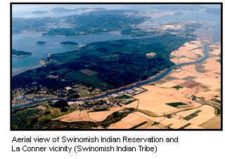
(Seattle—July 23, 2014) The U.S. Environmental Protection Agency announced today it is awarding over $756,000 to the Swinomish Indian Tribal Community to research coastal climate impacts to traditional foods, cultural sites and tribal community health and well-being. The combination of sea level rise, wave impacts, and shoreline development will change coastal ecosystems that support Swinomish first foods and place-based relationships, which in turn impacts community health and well-being.
The funds will be used to: · Develop a model showing projected coastal erosion due to sea-level rise, storm surge, and wave energy through Year 2100 on the shores of the Swinomish Reservation · Map the vulnerability of Swinomish coastal ecosystem habitats of first foods and culturally significant sites · Support the Swinomish Climate Change Initiative · Create educational and outreach tools for Swinomish community members and Coast Salish communities · Assess research results and develop adaptive strategies EPA funds research focused on tribal communities through the Science to Achieve Results program. Because many tribes rely on natural resources, it is essential for tribal-focused research to identify possible environmental health risks and the most efficient methods of avoiding or addressing these risks.
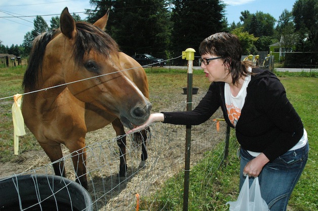
Sienna is fed by Colleen Chamberlain, weekend manager of the All Breed Equine Rez-Q, during its July 12 Kit-N-Kaboodle. — image credit: Kirk Boxleitner
MARYSVILLE — Organizers deemed the All Breed Equine Rez-Q’s July 12 Kit-N-Kaboodle barbecue and raffle a success, but more fundraisers are needed, so an Aug. 16 open house at 2415 116th St. NE is planned.
Dale Squeglia, founder and president of the nonprofit group, explained that it needs a horse quarantine station that will cost about $20,000.
“And we’re not even close to having that amount of money,” said Squeglia, who pointed out that it costs $8,000 just to supply the horse rescue with enough hay for a year. “Our hay loft is almost down to nothing right now.”
One of the horses that will benefit from the horse quarantine station is Biscuit, whom volunteer Colbie Cooper explained is a descendant of the famous racehorse Seabiscuit.
Cooper gave visitors guided tours of the horse rescue’s stalls and pastures during the Kit-N-Kaboodle, and elaborated on the other needs faced by the horses.
“Blackberry is a miniature donkey who might be pregnant, so we need to have that checked out,” Cooper said. “If it’s a boy, we should call it Boysenberry.”
Sienna is a Western Trail riding horse who’s spent the past several months recovering from being ridden with a leg injury for years, while Toffee suffered from severe obesity. Many of the rescue’s horses, including Jim and Lucy, were abused by their former owners, while others were surrendered to the rescue because their owners no longer had the time or money to care for them.
In addition to money, the horse rescue could always use more volunteers like Cooper, who can be trained to perform basic tasks such as feeding and watering the horses, cleaning stalls, grooming and exercising them, sweeping the barn and cleaning the grounds.
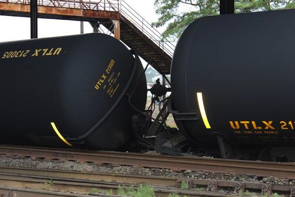
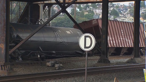
Courtesy Dana Robinson Slote Seattle City Council via radio station KPLU No one was hurt—this time. The first oil train derailment in Washington State happened under the Magnolia Bridge.
Indian Country Today, 7/25/14
Spills. Explosions. Deaths. Injuries.
The oil train that jumped the tracks outside Seattle the other day did not do any of those things, but it still highlighted concerns about rail transport of crude, especially highly flammable oil sands bitumen.
The 100-car train operated by Burlington Northern Railroad, filled with crude from the Bakken oil fields, was pulling out of the Interbay rail yard going five miles per hour when one locomotive, a buffer car carrying sand, and three tanker cars derailed at about 2 a.m. on July 24, the Associated Press reported. Two of the tankers tilted, one to a 45-degree angle, a railway spokesman told AP. That one had to be pumped out and hauled off for repairs.
As with the other half-dozen or so industrial-train derailments over the past year—starting with the runaway train that vaporized the center of 6,000-population Lac Mégantic in Quebec, Canada, along with 47 people last summer—the Quinault Indian Nation was on hand to warn about the perils of this type of transport.
“It was sheer luck that the cars, carrying 100 loads of Bakken crude oil, didn’t spill or even catch fire,” Quinault Indian Nation President Fawn Sharp said in a statement. “If that had occurred the chances are there would have been tragic loss. If fire had occurred, the odds are it would have burned out of control for days, and oil would have made its way into Puget Sound. People need to know that every time an oil train travels by, this is the risk that is being taken.”
Tribes are not alone in their unease. Local officials also expressed consternation.
“I’m very concerned that large volatile oil trains pose significant risk for derailment, fire, explosion, loss of property and life,” King County Executive Dow Constantine told MyNorthwest.com. “We need to have a conversation about what is appropriate to ship through these heavily populated areas and what kind of notice people deserve that these shipments are taking place.”
The Quinault and other groups fiercely oppose proposals for oil train export terminals at Vancouver and Grays Harbor.
“These accidents have occurred before,” said Sharp, who is also president of the Affiliated Tribes of Northwest Indians and area vice president of the National Congress of American Indians, after the Seattle derailment. “They will occur again. Even with the new safety measures proposed by President [Barack] Obama and Governor [Jay] Inslee, the accidents will occur. The rail and bridge infrastructure in this country is far too inadequate to service the vast expansion of oil traffic we are witnessing.”
The railroad company’s assertion that there had been no public threat because no oil had escaped also came under scrutiny.
“I have to disagree with the statement that there was no public threat,” said Sharp in the Quinault statement. “There was. In fact, there is a public threat every time an oil train passes by. There have been too many accidents, too many derailments, too many fires and too many spills.”
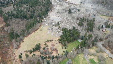
A photo taken immediately after the March 22 slide that killed 43 people and destroyed dozens of homes in Oso, Washington. A new scientific reports says a history of landslides and a huge volume of precipitation were big contributors to the slide. | credit: Washington Department of Transportation
SEATTLE — Scientists have concluded that rain, groundwater seepage and a long history of big landslides likely contributed to the massive landslide of March 22 that killed 43 people and destroyed dozens of homes near Oso, Washington.
Those findings came out Tuesday, the result of a scientific team’s rapid-fire assessment of geology and localized factors.
Joe Wartman, a University of Washington associate professor of civil and environmental engineering and a co-lead author of the study, said rainfall very likely played a key role in the slide.
“It mobilized as the water entered the landslide mass. It raised the water pressure in that mass,” Wartman said, “And as a result the landslide mass lost its strength and it became a fluidized mass of earth and material.”
The U.S. Geological Survey estimates that 7.6 million cubic meters of earth slid down across the Stillaguamish River, spreading out for more than a kilometer.
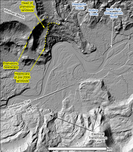
The researchers also looked further back in history, reviewing evidence from a number of large landslides in the Stillaguamish Valley around Oso during the previous 6,000 years. The team estimated that, based on a review of carbon dating and maps of 15 similar historic landslides nearby, slides such as the March event have happened in the same area as often as every 400 to 1,500 years historically.
“The real different thing about that particular spot was how much it had failed in the very recent past,” said Dave Montgomery, a geomorphologist with the University of Washington and co-author of the report. “It had been chewed on a lot by prior failures.”
A 2003 lidar map of ground conditions where the Oso slide occurred.
The report authors said the landslide occurred in two phases. The first slope failure was a repeat of previous slides that had been documented as far back as the 1950s at that site. The most recent one to contribute to the March slide took place in 2006.
The second phase of the March 22 event tapped into a much deeper landslide history at the site.
“You have the really big ones from thousands of years ago,” Montgomery said, “But why did the piece of the slope fail that did? It was different from some other areas up and down the valley due to the history of failure in recent decades, which exacerbated the stability problem.”
The report raised a question that was brought up in the immediate aftermath of the slide: what role did logging play? But the authors said that they were “not in a position to answer the question of what degree forest practices contributed to this slide.” Any conclusions would require further modeling and were beyond the scope of this four-day reconnaissance effort, they said.
Logging can contribute to weakened root strength, allowing hillsides to slough off in heavy rain. But Montgomery said the team was pretty comfortable ruling out that idea because the slide was too big and roots would have been too thin to make a difference in preventing the massive amount of earth from loosening.
Another potential connection to logging is from the removal of trees that would otherwise have absorbed some of the precipitation, preventing it from seeping deep into the soil and loosening it. Groundwater seems to have been a key contributor to the destabilization of the slope near Oso, the report authors concluded. Montgomery said the team saw seeps of water coming into the exposed face, or scarp, of the landslide from neighboring creek basins to the east.
“We located five or six groundwater seeps where water is coming out of the wall of the slide and forming a little stream that is running across the scar,” Montgomery said. That stream could have destabilized the earth far below the surface of the slide, contributing to its size and extensive runout zone.
The authors concluded that methods to identify and predict potential landslide runout zones need to be revisited and re-evaluated. The use of LIDAR imagery could also provide a great deal of assistance in gathering historic evidence that landslides of this magnitude have run across the valley before, said Jeff Keaton, a principal engineering geologist with AMEC Americas, who contributed to the report.
“That would be a really helpful step in understanding how widespread this kind of process actually is,” he said.
But there’s more digging to be done, literally, said Joe Wartman.
“The hole we have at this point is understanding what was going on underneath the ground surface,” Wartman said. “I think the next big thing is drilling holes into that landslide and the nearby vicinity to get an understanding of what is underneath that large landslide.”
The authors called for further modeling in order to better understand to what degree logging or the Stillaguamish River, which was eating away at the toe of the slope, may have contributed to the catastrophic slide.
The USGS and others will be conducting field research in the coming months. You can read the full report here.
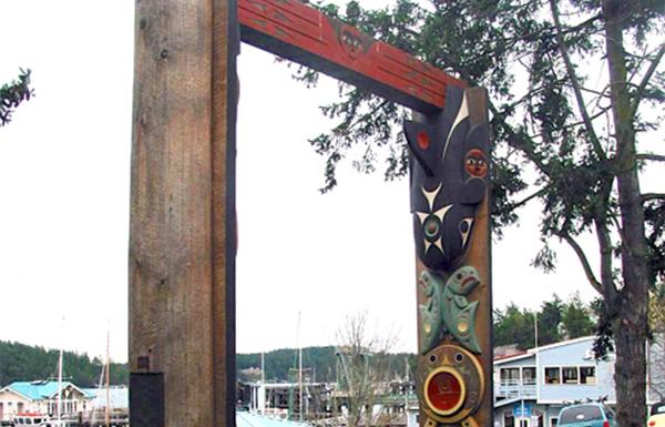
Residents of San Juan Island, Washington, the original home of the Lummi, Samish and Songhees peoples, are raising money for the care and preservation of house posts that overlook the harbor in the port town of Friday Harbor.
The house posts were carved by noted artist Susan Point, Musqueam, and acquired by residents 10 years ago to publicly honor the indigenous heritage of the island. The house posts, titled Interaction, tell the story of the interdependence of humans and animals in caring for the environment that sustains them.
“From the time of its unveiling, Interaction has become a gathering place for islanders and visitors—especially children, awed by the sculpture’s size, engaging motif, and deep, colorful carvings,” Barbara Marrett writes, in an article posted to SanJuanJournal.com. “Because children are drawn to touching the cougar scratches on the woman’s leg, over the years the paint and wood [have] been worn down in this area and other places where they have been loved and climbed upon.”
‘Interaction’ house posts by Susan Point. Source: susanpoint.com.
Interaction, which cost $65,000 in 2004, is now estimated to be worth $400,000, according to Marrett.
The house posts will be restored and repainted by a team of artists from Point’s studio. A community/Tribal celebration will follow the completion. Questions: Linda@sjihome.com.
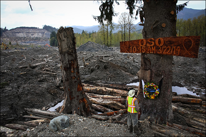
Ben Woodward looks up at a sign commemorating the moment of the Oso mudslide. The wooden memorial was attached to a towering spruce tree, one of the few in the debris field left standing after the disaster. (AP Photo/seattlepi.com, Joshua Trujillo)
EVERETT, Wash. – The Snohomish County sheriff’s office says search and rescue personnel believe they have located the last body from the deadly March 22 mudslide that killed 43 people at Oso.
Although the search for victims ended in April, workers have been screening debris and watching for the body of 44-year-old Molly Kristine “Kris” Regelbrugge.
Details were expected to be released at a news conference Tuesday afternoon in Everett.
Her husband, Navy Cmdr. John Regelbrugge III, also was killed in the slide that hit their home. His body was one of the 42 recovered earlier.
The discovery came on the same day that a team of scientists released the results of a report into the causes of the deadly mudslide.
The report says intense rainfall likely played a major role in triggering the slide, but that many other factors also contributed, such as previous landslide activity that also weakened the slope that collapsed.
The team says the slide, the deadliest in U.S. history, occurred in two major stages. A fast-moving mudflow remobilized a 2006 slide, bringing down old slide deposits across the valley. Another slide followed a few minutes later.
The report makes several broad recommendations that include doing an examination of landslide risks and communicating the information to the public.
TULALIP — A Tulalip woman convicted of murder in the 2012 death of her young daughter won’t learn her punishment until early next month.
Christina Carlson was scheduled to be sentenced Monday in U.S. District Court in Seattle. The hearing was pushed back to Aug. 4.
Carlson, 38, pleaded guilty in April to second-degree murder and criminal mistreatment. Lawyers have agreed to recommend a sentence between eight and 13 years. A federal judge isn’t obligated to follow the attorneys’ recommendations. Carlson faces up to life behind bars.
Her daughter, Chantel Craig, 1 ½, suffered from severe malnutrition and died after paramedics found her. Chantel and her sister, 3, were living with Carlson in a car on the Tulalip Indian Reservation.
The girls had sores all over their bodies and were covered in feces, lice and maggots. Chantel wasn’t breathing when paramedics reached her. They were unable to revive her. The older girl was unconscious and suffered seizures. She was treated for dehydration and skin sores from prolonged exposure to feces and urine.
The girls were kept buckled into their car seats for hours. Carlson hadn’t changed their diapers for days despite having an unopened package of clean diapers in the trunk of the car. The girls also hadn’t been adequately fed in several days, possibly longer.
Evidence also showed that Carlson smoked heroin in the car with the girls inside.
The day that Chantel died Carlson left them alone for several hours to visit with nearby neighbors. She used their phone in an attempt to buy drugs. The neighbors eventually persuaded her to go check on the girls.
Chantel wasn’t breathing and her other daughter wasn’t responsive. She ran back up the road and called 911.
Carlson and the girls had for months been the focus of on-again, off-again searches by state and tribal child welfare workers. Their grandmother called Child Protective Services in December 2011 with concerns that the girls were being neglected.
Carlson had lost custody of at least three other children because of her drug use and neglect, court papers said.
In a terrible coincidence, state social workers closed the investigation hours before Chantel died. They hadn’t been able to find her or Carlson. The woman and her daughters had for weeks been living in her car down a dirt road on the reservation.
By Kim Kalliber, Tulalip News and Patty Thometz, Grove Church
Staff and volunteers from the Grove Church in Marysville continue to expand their iheart outreach campaign in an effort to better reach out to the Marysville and Tulalip communities.
Each year, 150 plus volunteers pay a fee to go on a missions’ trip to serve our community by beautifying grounds of local schools, repairing/painting, building shelters, park benches and dug-outs for parks and baseball fields around Marysville.
Patty Thometz, Children’s Pastor at the Grove Church said, “This summer, we will be expanding our reach to children through iheartGO, a big block party for kids at various locations in Marysville. We want to go where there’s a lot of children.”
Youth in fourth through eighth grade are encouraged to volunteer a week of their time to serve others and give back to their communities. This includes everything from set up, clean up, leading the games and crafts.
The Tulalip Boys and Girls Club is one of five host locations. Chuck Thacker, Unit Director of the Tulalip Boys and Girls Club, has warmly invited the Grove Church campaign folks to partner with them for a day of fun, bounce houses, face painting, crafts, games, free hot dogs and much more. This event will be on Friday, August 8, from 11:00 a.m. to 2:00 p.m.
“It’s wonderful what you [Tulalip] do for the kids at the Boys and Girls Club and the Grove Church is excited to be a part of this learning partnership. I love outreach and I love working with kids,” said Thometz, with a smile.
For more information about the Grove Church and its outreach programs, please visit grovech.org.
Award Winning Wine and Food Weekend Offers Advance Purchase Through Ticketmaster
Tulalip, Washington — “Buy early; get in,” says Tulalip Resort Casino President/COO Ken Kettler. He is referring to the line of disappointed Taste of Tulalip fans that were unable to enjoy the award-winning November weekend of wine, food and tradition, as the 2013 event sold out. This year tickets will go on pre-sale at 9:00 a.m. PDT on July 18. Seats for the Friday, November 14 celebration dinner may be purchased by calling (360) 716-6888, and the passes for the Saturday, November 15 events can be paid for via Ticketmaster at http://www.ticketmaster.com/.
The weekend kicks-off with Friday night’s multi-course Celebration Dinner, prepared by Executive Chef Perry Mascitti and his team, paired with premium wines from around the globe selected by sommelier Tommy Thompson. Seating is limited to 400 guests. Saturday is filled with a plethora of wine and food demos, chef challenges, a wine seminar, a VIP Magnum party and is capped with the Grand Taste – featuring over 120 wineries from Washington, Oregon, California, New Zealand and Germany, along with a craft beer “pool garden”. Attendance is limited to 2,000.
Taste of Tulalip’s 2014 culinary guest stars include public television show host and producer Ming Tsai along with wine columnist, author and educator Anthony Giglio. Both will be featured at events throughout the weekend. The honorary winemaker is Woodinville Wine Cellar’s maestro Sean Boyd. Local Fox Q13 television celeb Bill Wixey returns for a second year as guest emcee and will be joined by fellow team member Kaci Aitchison.
Tickets are priced at:
Celebration Dinner $195
All Access Saturday Pass $350
Grand Taste $95
Hotel rooms and spa appointments will become near and dear during this two-day extravaganza. Kettler also suggests that guests reserve their getaway room early at the AAA Four Diamond resort by going to www.tulalipresort.com or phoning 1-866-716-7162.