In a precedent-setting ruling that has national and international implications, Ontario Superior Court Justice Carole Brown has ruled that three separate lawsuits against the Canadian mining company HudBay Minerals can proceed to trial even though the plaintiffs are from another country.
“As a result of this ruling, Canadian mining corporations can no longer hide behind their legal corporate structure to abdicate responsibility for human rights abuses that take place at foreign mines under their control at various locations throughout the world,” said Murray Klippenstein, of Toronto’s Klippensteins, Barristers & Solicitors, who’s representing 13 Maya Qeqchi from El Estor, Izabal, Guatemala.
The Maya Qeqchi turned to Canada’s court system over three separate injustices that were carried out by employees of the Fenix Mining Project, a nickel mine that was acquired by HudBay Minerals after the company purchased Skye Resources in 2008.
In January 2007, Skye Resources (subsequently renamed HMI Nickel) requested the eviction of five Maya Qeqchi communities from their ancestral lands.
At the time, the Fenix project was subject to land claims by the local communities, who maintained that Guatemala breached international law by approving the mining concession because it failed to carry out prior consultations.
“With the force of the army and police”, observes Rights Action, “company workers took chainsaws and torches to people’s homes, while women and children stood by. The mining company claimed that they maintained ‘a peaceful atmosphere during this action.’”
As if it wasn’t enough to displace the Maya Qeqchi families, on January 17, 2007, 11 women from the community of Lote Ocho were gang raped by the police, military and security personnel.
In their lawsuit against Hudbay, the women are seeking $1 million each in compensation for the pain and suffering they’ve endured, in addition to another $4 million in punitive damages because of the “extreme and heinous nature of the attacks against them.”
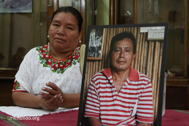
The second lawsuit against Hudbay is led by Angelica Choc, the widow of Adolfo Ich Chaman. A respected community leader, a school teacher and father, Adolfo was brutally murdered by the company’s mine security. Their son, José, who witnessed the killing, says the security guards hacked at Adolfo with a machete before shooting him in the head. Adolfo was trying to help restore calm in the region after hearing gunshots from the direction of the company’s buildings.
A third lawsuit was filed for German Chub, a young father who was shot at close range by the head of the security personnel the very same day that Adolfo was murdered. As a result of the injuries that he sustained, German Chub was paralyzed and no longer has use of his right lung.
“There will now be a trial regarding the abuses that were committed in Guatemala, and this trial will be in a courtroom in Canada, a few blocks from Hudbay’s headquarters, exactly where it belongs,” said Mr. Klippenstein. “We would never tolerate these abuses in Canada, and Canadian companies should not be able to take advantage of broken-down or extremely weak legal systems in other countries to get away with them there.”
“Today is a great day for me and all others who brought this lawsuit,” said Angelica Choc. “It means everything to us that we can now stand up to Hudbay in Canadian courts to seek justice for what happened to us.”
“This judgment should be a wake-up call for Canadian mining companies,” added Cory Wanless, co-counsel for the Mayas along with Mr. Klippenstein. “It is the first time that a Canadian court has ruled that a claim can be made against a Canadian parent corporation for negligently failing to prevent human rights abuses at its foreign mining project. We fully expect that more claims like this one will be brought against Canadian mining companies until these kinds of abuses stop.”
At a recent Native American conference held in Nashville, celebrated American Indian leader Onondaga wisdomkeeper Oren Lyons said, “If Obama approves the pipeline, this is the deal breaker.” He was referring, of course, to the Keystone XL Pipeline.
Just in the past few days, President Obama in a speech on climate change stated that the pipeline would not be approved if it resulted in more “carbon pollution.” This statement is being interpreted in different ways. For those who oppose the pipeline, Obama is setting the stage for rejection of Keystone; for those who favor the pipeline, he is hinting at approval. But one thing is certain: If Obama follows the logic of his statements, the pipeline is “dead in the water.”
The pipeline, by scientific analysis, would result in massively more “carbon pollution”; in fact, 600 parts per million CO2. The maximum safe limit for the atmosphere is 350 parts per million.
Another thing is certain, Native Americans are preparing in case Obama approves the heinous project: Native communities are set for massive civil disobedience to stop the pipeline from crossing the Northern Plains. Indian people are in special training called the “Moccasins on the Ground Tour of Resistance” from South Dakota to Oklahoma.
For Native people, the pipeline means death. The Keystone oil is extracted from tar sands in Canada. Because of the pipeline, Native people there have been exposed to contaminated water, and arsenic has been found in moose meat, a staple of their diet. In Alberta, extraction of tar sands oil already has been linked to a 30 percent elevated rate in rare cancers and rare autoimmune disorders. This pipeline means genocide!
In Rapid City, S.D., representatives of 11 Native American nations angrily stormed out of a May meeting with federal government officials in protest of the pipeline. Tribal officials refused to meet with low-level government representatives. Oglala Sioux President Bryan Brewer said, “We will only talk with President Obama.”
Also, the pipeline would run through sacred sites and traditional burial grounds, and pollute the Oglala Aquifer, which provides water to millions of citizens in the Midwest, including non-Indians.
Indian people are prepared to risk their lives by standing in front of the bulldozers, but this is not just a fight for Native people; it’s a fight for all Americans. Environmentalists, land owners and ranchers are joining with Indian nations in opposition to this abominable project.
At a recent press conference, the tribes said “Tar sands pipelines will not pass through our collective territories under any conditions or circumstances.” This is a life-and-death struggle for Native Americans.
The tiny creatures had been abandoned and left to their nest as the wildfire raged closer in the Sierra National Forest in mid-June.
Too young to fly, two newborn Western screech owls could not escape the flames on their own. But no one knew they were there until the tree they were hiding in was felled to form part of the fire control line. The birds tumbled out of their nest onto a roadway, the U.S. Forest Service reported in a July 18 blog entry.
Two firefighters saw them, scooped them up and summoned assistance, which brought Anae Otto, a wildlife biologist for the Sierra National Forest’s Bass Lake Ranger District.
“My heart was racing when I received the report of owls on the ground in the Carstens Fire,” Otto told the forest service after making the 2.5-hour drive to retrieve the birds. “I was concerned because there were no details as to how old they were, how long they had been exposed, etc. I was relieved to find the owlets alive and in fair condition. So much of my daily work deals with habitat protection. It was very rewarding to provide direct assistance to an animal in need.”
Otto estimated they were between two and three weeks old. She wrapped them in a towel and brought them home overnight, the forest service said, then called for reinforcements the next day. That brought in wildlife rehab specialist Terri Williams, a volunteer for the Fresno Wildlife Rescue and Rehabilitation Service.
Now the two owls, dubbed Puff and Fluff, are being cared for until they can fly. At last report they were chowing down daily on 25 crickets, two mice and a chick.
It was a heartwarming moment in a wildfire season fraught with tragedy at the death of 19 firefighters in Arizona in June. (Related: Hero Firefighters Named, Mourned, in Arizona)
The Western screech owl, Megascops kennicottii, is plentiful over the western half of Turtle Island, although, as with their brethren the spotted owl, their habitat has been encroached upon by the barred owl as well as eroded by logging and development. (Related: Pot-Farm Raticide May Be Killing Spotted Owls; Hoopa Tribe Investigates)
Puff and Fluff will grow to be 7½ to 10 inches long, according to information on the species from the Arizona Game and Fish Department. They will weigh between four and seven ounces, and their wingspan will reach 21 inches or so, the department said.
The Carstens fire raged for 10 days between June 16 and June 26, according to CalFire, the website for California fire incidents. It burned 1,708 acres in total, including acreage in the Sierra National Forest.
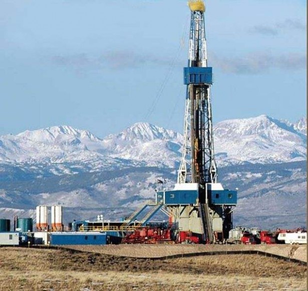
The Obama Administration has proposed new regulations for hydraulic fracturing on 756 million acres of public and tribal lands. The rules were written by the drilling industry and will be streamlined into effect by a new intergovernmental taskforce, established by the president, to promote fracking — a practice that has been linked to water poisoning, air pollution, methane emissions and, most recently, earthquakes. Environmentalists, many of whom are highly skeptical that fracking can even be regulated, hope to use a brief window for citizen participation in the rule approval process to leverage the growing anti-fracking movement.
The Interior Department’s Bureau of Land Management (BLM) — the government agency that manages the public lands in question — follows a dual and often conflicting mandate. Although it is charged with conserving lands for recreation and biological diversity, it must also ensure the commercial development of natural resources. The bureau tends to focus heavily on the latter part of its mission, and it has auctioned off public land for resource extraction, including oil and gas development, while following drilling regulations that were last updated in 1988, before fracking became a common practice.
“Under the old regulations, an operator would have to disclose non-routine techniques,” said BLM spokesperson Beverly Winston. “Now, hydraulic fracturing is routine, so nobody discloses it. It’s my understanding that probably 90 percent of wells on public lands use hydraulic fracturing.”
The newly proposed regulations will provide superficial environmental safeguards against industry excesses while shielding drillers and the government from the legal challenges that have begun cropping up. In April, for instance, a California judge ruled in a lawsuit brought by the Sierra Club and the Center for Biological Diversity that the BLM had failed to take a “hard look” at the impact of fracking on federal land in the state and halted the issuance of fracking leases for the Monterey shale region until an assessment of its environmental impact is completed. The proposed laws, however, will give the BLM legal cover to keep the frack leases flowing.
Former Interior Secretary Ken Salazar, who helped draft the laws, resigned from his post in January to take a job with WilmerHale. The corporate law firm’s website boasts “our lawyers strive to reduce liability and transform environmental compliance obligations into opportunities.”
Those wondering what opportunity looks like to drillers in regions originally set aside for conservation need only visit the Allegheny National Forest in Western Pennsylvania, a state that has opened its arms to drillers in recent years. Nearly 4,000 oil and gas wells were drilled in the Allegheny between 2005 and 2011.
“Where there were once remote areas of the forest there is now oil and gas infrastructure,” said Ryan Talbott of the Allegheny Defense Project. “If you are a recreationist going to go out and go hiking, camping, fishing, what might have been your favorite area before is now a sea of roads and pipelines and well sites.”
In 2009, under pressure from Allegheny Defense and other environmental groups, the Forest Service sought to monitor the drilling, implement environmental safeguards and provide a measure of planning to the spaghetti network of drill sites. But 93 percent of the mineral rights in the state are privately held and the Forest Service, in a case currently under review by the 3rd Circuit Court of Appeals, was sued by the gas companies who claim their property rights were violated.
Although not yet to the extent witnessed in Allegheny, fracking has commenced in other parts of the country where the BLM holds mineral rights, particularly out West. “We’re drilling all over the place,” President Obama told an audience in New Mexico last year, announcing plans to open millions more acres to the oil and gas industry. In the way of protection, however, Obama’s new rules follow the Pennsylvania model, barely scratching the surface when it comes to monitoring what occurs below.
White House visitor logs show the president’s top adviser on energy and climate, Heather Zichal, met with the American Petroleum Institute, the Independent Petroleum Association of America and other industry groups 20 times last year in the run up to the rules proposal. They were further honed to industry specifications in a series of meetings between the oil and gas lobby and the White House Office of Budget Management, and are based on a piece of model legislation authored by Exxon for the American Legislative Exchange Council.
Under the rules, drillers will report chemicals used in fracking to an industry run site, FracFocus.org, already used in Pennsylvania and other states. The disclosures won’t need to be made until after a well is fracked. Nor will they be vetted for accuracy. Certain chemicals won’t even be disclosed at all, since they constitute alleged trade secrets. Furthermore, the rules would sanction drilling in close proximity to homes and schools, as well as allow wastewater — the toxic byproduct the of fracking — to be stored in open, outdoor pits.
Meanwhile, the rules weaken a requirement meant to ensure the structural integrity of drilling wells, which can leak methane and other chemical contaminants if cracked. Instead of having to submit documentation for each well, companies will only need report one of all their wells within a geological area.
“Using a single well as representative of all wells completely ignores the likelihood that one in 12 wells have some sort of well casing failure,” said Hugh MacMillan, a senior researcher with Food and Water Watch. “Six to eight percent of well casings fail within the first year, with higher percentages over time.”
MacMillan also expressed fears that the proposed regulations won’t cover a newer technique, known as acidizing, which involves pumping acid into the ground to dissolve rock formations and create pathways in shale for oil to flow out.
Underlying all these concerns is the fear held by many environmentalists that, no matter how heavily the industry is regulated, fracking is inherently toxic. “Trying to regulate fracking is like trying to build a safe cigarette,” said scientist and activist Sandra Steingraber. “You can put filters on cigarettes. You can have low tar cigarettes. But the answer to avoiding cancer from smoking is not to smoke.”
The issue of whether to push for more stringent laws that will mitigate against the impact of drilling or to advocate for the abolition of the practice has caused some considerable fissures in the environmental movement. The Natural Resources Defense Council worked with the drilling industry to write legislation governing fracking that was approved by lawmakers in Illinois last month, while those pushing for an outright ban in the state launched a three day sit-in in the governor’s office against the measure.
Steingraber favors a ban and was ejected from the Illinois statehouse for disrupting legislators following the approval of the fracking bill. Nevertheless, she’s spearheading an initiative to increase the already unprecedented number of comments the BLM has received during the public input period on the Obama-Exxon fracking rules. When the BLM first opened up the proposed laws for public review this spring they were inundated with 177,000 submissions, prompting the bureau to extend the submission deadline to August 23. Steingraber is working to ensure that public comments keep flowing and that this window of public participation furthers the overall anti-fracking movement.
In New York last winter, as the state’s moratorium on fracking expired and its Department of Environmental Conservation (DEC) began preparing to file rules that would allow for drilling, she jumpstarted a similar effort. Through a website she established, ThirtyDaysOfFrackingRegs.com, Steingraber — a molecular biologist with a background in public health — broke down piece-by-piece the proposed laws, explaining their environmental consequences and providing a template for critics to submit their own comments. Ultimately, Steingraber said the site was responsible for 25,000 submissions to the DEC — more than 10 percent of the 200,000-plus mostly-critical comments the department received. These objections ended up being an important compliment to the hundreds of protests that took place against fracking statewide. The DEC eventually let the deadline to file rules lapse, which has delayed the prospect of fracking in New York for at least a year.
It was a victory even fracking’s most committed opponents thought slim at the time. The gas industry had spent millions of dollars around the state to ensure it could make good on drilling leases it had already purchased. A Freedom of Information Act request by the Environmental Working Group revealed that, in the run-up to the deadline, New York’s DEC deputy commissioner Steven Russo had already sent potential regulations to drilling lobbyists for their approval.
Despite their success in New York, Steingraber and other anti-fracking activists are fighting an uphill battle at the federal level. In a speech at Georgetown University last month, the president touted “clean burning natural gas” as part of an “all-of-the-above” energy strategy and vowed to increase drilling in order to tackle the climate crisis and foster energy independence.
“The administration has a stated goal to increase American energy production,” said BLM spokesperson Beverly Winston. “A lot of that’s going to come from public land, whether that’s renewable energy or oil and gas.”
With the public comment period serving essentially as window dressing for an otherwise backdoor process, Steingraber said she isn’t looking at the submission of comments to the BLM as an end in and of itself but rather as a “gauntlet” thrown down. She also called them “a meter of citizen opposition” that activists can point to as they build on-the-ground mobilizations.
The struggle will likely come to a head on August 22, the eve of the comment deadline, when environmental groups in the coalition Americans Against Fracking will stream into Washington, D.C., to deliver written comments to the BLM. What happens next will be as much a test of the democratic process as the strength of this growing movement.
“The very bedrock of this nation,” says Steingraber “is not for fracturing.”
It is not unusual for swarms of small earthquakes to precede a volcanic eruption. They can reach a point of such rapid succession that they create a signal called harmonic tremor that resembles sound made by various types of musical instruments, though at frequencies much lower than humans can hear.
By Vince Stricherz | University of Washington 07/15/2013
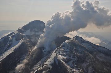
Redoubt Volcano’s active lava dome as it appeared on May 8, 2009. The volcano is in the Aleutian Range about 110 miles south-southwest of Anchorage, Alaska.Image-Chris Waythomas, Alaska Volcano Observatory
A new analysis of an eruption sequence at Alaska’s Redoubt Volcano in March 2009 shows that the harmonic tremor glided to substantially higher frequencies and then stopped abruptly just before six of the eruptions, five of them coming in succession.
“The frequency of this tremor is unusually high for a volcano, and it’s not easily explained by many of the accepted theories,” said Alicia Hotovec-Ellis, a University of Washington doctoral student in Earth and space sciences.
Documenting the activity gives clues to a volcano’s pressurization right before an explosion. That could help refine models and allow scientists to better understand what happens during eruptive cycles in volcanoes like Redoubt, she said.
The source of the earthquakes and harmonic tremor isn’t known precisely. Some volcanoes emit sound when magma – a mixture of molten rock, suspended solids and gas bubbles – resonates as it pushes up through thin cracks in the Earth’s crust.
But Hotovec-Ellis believes in this case the earthquakes and harmonic tremor happen as magma is forced through a narrow conduit under great pressure into the heart of the mountain. The thick magma sticks to the rock surface inside the conduit until the pressure is enough to move it higher, where it sticks until the pressure moves it again.
Each of these sudden movements results in a small earthquake, ranging in magnitude from about 0.5 to 1.5, she said. As the pressure builds, the quakes get smaller and happen in such rapid succession that they blend into a continuous harmonic tremor.
“Because there’s less time between each earthquake, there’s not enough time to build up enough pressure for a bigger one,” Hotovec-Ellis said. “After the frequency glides up to a ridiculously high frequency, it pauses and then it explodes.”
She is the lead author of a forthcoming paper in the Journal of Volcanology and Geothermal Research that describes the research. Co-authors are John Vidale of the UW and Stephanie Prejean and Joan Gomberg of the U.S. Geological Survey.
Hotovec-Ellis is a co-author of a second paper, published online July 14 in Nature Geoscience, that introduces a new “frictional faulting” model as a tool to evaluate the tremor mechanism observed at Redoubt in 2009. The lead author of that paper is Ksenia Dmitrieva of Stanford University, and other co-authors are Prejean and Eric Dunham of Stanford.
The pause in the harmonic tremor frequency increase just before the volcanic explosion is the main focus of the Nature Geoscience paper. “We think the pause is when even the earthquakes can’t keep up anymore and the two sides of the fault slide smoothly against each other,” Hotovec-Ellis said.
She documented the rising tremor frequency, starting at about 1 hertz (or cycle per second) and gliding upward to about 30 hertz. In humans, the audible frequency range starts at about 20 hertz, but a person lying on the ground directly above the magma conduit might be able to hear the harmonic tremor when it reaches its highest point (it is not an activity she would advise, since the tremor is closely followed by an explosion).
Scientists at the USGS Alaska Volcano Observatory have dubbed the highest-frequency harmonic tremor at Redoubt Volcano “the screams” because they reach such high pitch compared with a 1-to-5 hertz starting point. Hotovec-Ellis created two recordings of the seismic activity. A 10-second recording covers about 10 minutes of seismic sound and harmonic tremor, sped up 60 times. Aone-minute recording condenses about an hour of activity that includes more than 1,600 small earthquakes that preceded the first explosion with harmonic tremor.
Upward-gliding tremor immediately before a volcanic explosion also has been documented at the Arenal Volcano in Costa Rica and Soufrière Hills volcano on the Caribbean island of Montserrat.
“Redoubt is unique in that it is much clearer that that is what’s going on,” Hotovec-Ellis said. “I think the next step is understanding why the stresses are so high.”
The work was funded in part by the USGS and the National Science Foundation.
Venomous brown recluses exist within a smaller range than many realize, and their existence may be threatened by climate change. CREDIT: Rick Vetter
Wynne Parry, LiveScience Senior Writer
Date: 27 April 2011 Time: 03:24 PM ET
Climate change may give America’s venomous brown recluse spiders a choice: Move to a more northern state or face dramatic losses in range and possible extinction, a new theoretical study suggests.
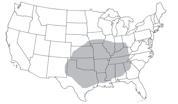
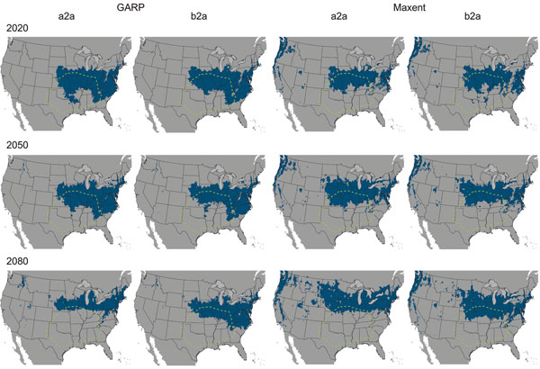
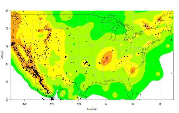
Currently,brown recluse spiders are found in the interior of roughly the southeastern quarter of the continental United States. Researcher Erin Saupe used two ecological computer models to predict the extent of the spider’s range in 2020, 2050 and 2080 given theeffects of global warming.
“The actual amount of suitable habitat of the brown recluse doesn’t change dramatically in the future time slices, but what is changing is where that area is located,” said Saupe, who was pursuing a master’s degree at the University of Kansas when she did the work. She is now a doctoral student there.
If the projections are correct, by 2080, perhaps only 5 percent of the spider’s current range — which extends from Kansas across to Kentucky and from Texas across to Georgia, including the states in between — would remain suitable for it. However, climate change could make portions of Wisconsin, Michigan, Indiana, Ohio, Pennsylvania, New York, Nebraska and South Dakota habitable to the spiders.
The shaded region represents the current distribution of the brown recluse. CREDIT: Erin Saupe/PLoS ONE
Arachnophobia
This may come as a surprise to some residents of these states. In many minds, brown recluse spiders – with their outsized reputation for bringing death, amputations and paralysis – already occupy most of the country, Rick Vetter, a research associate at the University of California, Riverside contends.
Vetter, one of the study authors, created the Brown Recluse Challenge, a 4½-year project. “I got tired of people telling me that brown recluses are all over the U.S and Canada, and I said, ‘Send them to me and I will identify them,'” Vetter said.
One thousand, seven hundred and seventy three spiders later, it was clear that any brown, eight-legged arachnid was at risk of misidentification as a brown recluse – 79 percent of the specimens he received from people across the country were not of the species Loxosceles reclusa, Vetter told LiveScience.
“People fear the unknown. … They like to tell scary stories, they are willing to believe bad things about things they don’t like anyway, so there is a lot of human psychology that is wrapped around the brown recluse,” he said. [Top 10 Phobias]
The challenge has since been picked up by the University of Florida.
In nature, brown recluses live underneath bark or logs in dry areas or underneath hanging rocks. But humans also create a good habitat for them in cellars, attics and garages, according to Vetter.
Their venom contains a toxin that causes skin to die, resulting in what are known as necrotic lesions. In about 90 percent of cases, the bite of a brown recluse has virtually no effect. The other 10 percent cause severe symptoms with potentially life-threatening complications. There are no solid statistics available, but Vetter estimates that one or two bite-induced deaths occur each year, typically in small children.
Homebody spiders
In spite of their affinity for human-created habitats, these spiders have little success establishing and spreading outside their native range. They may be transported when people move outside the spider’s native range, and they can infest a new house, but they won’t spread from there, Vetter said.
“Think about the Dust Bowl era,” he said. “How many thousands of people came to California, how many tens of thousands of boxes of possessions they brought with them, and how many hundreds of thousands of brown recluses came with them? And they didn’t establish a population in California.”
Brown recluses cannot travel on air currents, unlike some other spiders, which limits their means for transport. [How Spiders Fly Hundreds of Miles]
It is possible the spiders may be unable to move north quickly enough to establish in new habitat as parts of their current range become inhospitable, although it is conceivable that by hitching a ride with humans, the spiders may make the migration, the researchers write in a study published online March 25 in the journal PLoS ONE.
The study used two greenhouse gas emissions scenarios, one more dramatic than the other, derived from the Intergovernmental Panel on Climate Change. The two modeling programs took seven environmental variables related to temperature and precipitation into account.
Both of the emissions scenarios indicated new states could be invaded as far north as parts of Minnesota, Michigan and South Dakota. Both scenarios were run using the two ecological models, resulting in divergent trends. One model showed that the spiders’ habitable area would decrease with time, while the other showed an increase in habitable area.
The predictions should not be taken as gospel; the models aren’t perfect. Saupe used them to predict the current range of the brown recluse and found that it included the Atlantic coast states, farther east than where the spiders actually are. The discrepancy may be due to an error in the model, or it may be that spiders are being kept from the habitable territory closer to the coast by a barrier, perhaps the Appalachian Mountains, Saupe said.
“It is scary to think that if this much change could happen in one species, what could happen in the myriad species that exist all over the Earth?” Saupe said.
Two ecological models, named GARP and Maxtent, were used to project the range of the brown recluse, shown in blue, under two different greenhouse gas emissions scenarios: a2a and b2a from the IPCC. A2a assumed more dramatic climate change than b2a. CREDIT: Erin Saupe/PLoS ONE
You can follow LiveSciencesenior writer Wynne Parry on Twitter @Wynne_Parry. Follow LiveScience for the latest in science news and discoveries on Twitter @livescience and onFacebook.
DURHAM, NC – Some blue whales off the coast of California change their behavior when exposed to the sort of underwater sounds used during U.S. military exercises. The whales may alter diving behavior or temporarily avoid important feeding areas, according to new research.
The Southern California Behavioral Response Study exposed tagged blue whales in the California Bight to simulated mid-frequency (3.5-4 kHz) sonar sounds significantly less intense than the military uses.
“Whales clearly respond in some conditions by modifying diving behavior and temporarily avoiding areas where sounds were produced,” said lead author Jeremy Goldbogen of Cascadia Research. “But overall the responses are complex and depend on a number of interacting factors,” including whether the whales were feeding deep, shallow or not at all.
The study, funded by the U.S. Navy Chief of Naval Operations Environmental Readiness Division and the U.S. Office of Naval Research, appears July 3 in the Proceedings of the Royal Society B.
The scientists tagged the whales with non-invasive suction cups, which recorded acoustic data and high-resolution movements as the animals were exposed to the controlled sounds.
“The tag technology we use offers a unique glimpse into the underwater behavior of whales that otherwise would not be possible,” said Ari Friedlaender, a research scientist at the Duke Marine Laboratory.
The scientists found that some of the whales engaged in deep feeding stopped eating and either sped up or moved away from the source of the noise. Not all of the whales responded to the noise, and not all in the same way.
“Blue whales are the largest animals that have ever lived. Populations globally remain at a fraction of their former numbers prior to whaling, and they appear regularly off the southern California coast, where they feed,” said John Calambokidis, one of the project’s lead investigators of Cascadia Research.
That area of the ocean is also the site of military training and testing exercises that involve loud mid-frequency sonar signals. Such sonar exercises have been associated with several unusual strandings of other marine mammal species (typically beaked whales) in the past. Until this study, almost no information was available about whether and how blue whales respond to sonar.
“These are the first direct measurements of individual responses for any baleen whale species to these kinds of mid-frequency sonar signals,” said Brandon Southall, SOCAL-BRS chief scientist from SEA, Inc., and an adjunct researcher at both Duke and the University of California Santa Cruz. “These findings help us understand risks to these animals from human sound and inform timely conservation and management decisions.”
A related paper published July 3 by the same research team in Biology Letters has shown clear and even stronger responses of Cuvierâs beaked whales to simulated mid-frequency sonar exposures. Beaked whales showed a variety of responses to both real, military sonar in the distance and nearby simulated sonar. What the beaked whales were doing at the time appeared to be a key factor affecting their reactions.
U.S. President Barack Obama with the Navy’s F/A-18 Green Hornet. Photo: Official U.S. Navy Imagery/ CC by 2.0
By Lucy Wescott, Inter Press Service
The United States military, an organisation that consumes 90 percent of the country’s federal oil allowance, is trying to become a greener institution.
The U.S. Navy has said that by 2016 it will run one of its 11 carrier strike groups using biofuel. In a test run of the new approach in the Pacific Ocean, a novel mixture of jet fuel, algae and cooking grease powered FA-18 Super Hornets, a type of fighter aircraft.
Within a decade, half of the Air Force and Navy’s fuel needs will be met by alternative energy sources, according to Christopher Merrill, director of the International Writer’s Program at the University of Iowa.
Merrill, who penned an essay for Orion Magazine titled ‘The Future of War‘, suggested that with climate change posing an increasing threat to U.S. national security, another name for this pioneering strike group could be the Great Green Fleet.
The military also believes that the threat of climate change to U.S. security is not simply a temporary trend, Merrill said.
“I don’t view this as a one-off thing, I view this as somebody trying to look into the future, trying to figure out what (we) are going to have to do to defend the country,” Merrill said.
Climate change and security
In 2010, the Department of Defence recognised in its Quadrennial Defence Review (QDR) that climate change and energy will both play “significant roles in the future security environment”.
The report rendered the effect of climate disasters difficult to ignore: last year was the second most expensive year on record for the United States, with 11 weather-related natural disasters costing over 110 billion dollars in damages.
Marcus King, associate research professor of international affairs at the George Washington University, believes that threats from climate change would affect not only the United States through phenomena such as sea-level rise and droughts but the rest of the world as well.
The United States ought to be concerned that other nations, including U.S. allies, “could be constrained because they don’t have (the) adaptive capacity (to deal with climate change),” King told IPS.
“Once you look at global climate change as a threat, Africa has the least resistance…(and) it’s of strategic importance to the U.S.,” King said.
The Department of Defence recognised the potential increase in the Navy’s response to disasters abroad, reporting in the QDR that climate change is one factor “whose complex interplay may spark or exacerbate future conflicts”, along with cultural tensions and new strains of diseases.
Good PR?
But Leah Bolger, formerly with the U.S. Navy and now a peace activist, believes the green move to be more a publicity stunt than a progressive statement signalling changing times.
“I spent my (twenty) years in the military ambivalent about what the military policies were in foreign policy. It was a job…I didn’t really question my part in the military machine,” Bolger told IPS.
Now, however, Bolger called the Navy’s decision to make one carrier strike group green by 2016 “laughable”.
“(The green move is) like a page out of a PR book – something they can put out in their public affairs office to say, ‘We’re so mindful of the environment,’” Bolger said.
Still, one additional advantage of the green move is that the potential demand for alternative fuels could create a new market, Merrill told IPS. Already tax credits are being granted to wind farms, according to him.
“Once that market gets established, it’s likely that you’ll see the kind of innovations that came in the wake of the invention of the Internet,” he predicted.
Nevertheless, a change in the military’s energy consumption doesn’t necessarily mean a change in the behaviour of Americans, who consumed 19 percent of the world’s total energy resources in 2010, according to data from the U.S. Energy Information Administration, despite comprising around five percent of the global population.
Even if Americans knew about the Great Green Fleet, Bolger said, it wouldn’t do much to change their habits.
While the Great Green Fleet doesn’t necessarily improve the operational abilities of the Navy, the impetus is noble, King said. “If they have the ability to create demand (for alternative fuels)… I think that’s great, as long as it’s consistent with national security, which it is.”
Earthquakes equal to or bigger than magnitude 3.0 in the United States between 2009 and 2012. The background colors indicating earthquake risk are from the U.S. National Seismic Hazard Map. CREDIT: Science/AAAS
By Becky Oskin, Staff Writer
July 11, 2013
Two new studies of earthquakes near injection wells have seismologists using words rarely heard these days in earthquake science: prediction and warning.
The research has also renewed calls for better seismic monitoring and reporting in regions experiencing man-made earthquakes.
“Shale gas operations have completely changed our energy policy and people are injecting in places they’ve never injected before. If we’re going to do this safely, we need to address the environmental issues, including protecting water supplies and earthquake risk,” said Cliff Frohlich, a seismologist at the University of Texas Institute for Geophysics who was not involved in the new studies.
The two reports appear in today’s (July 11) issue of the journal Science.
Links between injection and earthquakes
In the Midwest, researchers discovered a warning signal that moderate-sized earthquakes may strike near injection wells, where mining companies dispose of waste fluids. At three sites in Oklahoma, Colorado and Texas, passing seismic waves from faraway earthquakes — the recent massive temblors in Japan, Sumatra and Chile — triggered swarms of small earthquakes. The seismic activity continued until magnitude-4 and magnitude-5 earthquakes struck, such as the large earthquakes near Prague, Okla., in November 2011. [7 Craziest Ways Japan’s Earthquake Affected Earth]
“We’ve been telling our operators for some time that this is one of the warning signs to look for,” said Austin Holland, a seismologist with the Oklahoma Geological Survey who was not involved in the study. “If you see remote triggering of your wells, it’s a clear indication that your faults are right at the failure point. It just took a little tickle, if you will, to trigger the earthquakes.”
In a separate study, researchers documented a clear link between earthquakes and production, or removing and injecting underground fluid, at Southern California’s Salton Sea Geothermal Field power plant. Every 500 million gallons of water pumped out of the ground caused one detectable earthquake per 11 days, according to the report.
“The thing that best predicted the earthquake rate was the net amount of water extracted from the ground,” said Emily Brodsky, lead study author and a seismologist at the University of California, Santa Cruz.
Scientists have long known that geothermal projects can trigger earthquakes, but some communities are wary of the seismic risk. Construction on a geothermal energy plant in Basel, Switzerland, was shut down in 2009 after fluid injection triggered earthquakes up to magnitude 3.4. Brodsky’s study offers a new statistical model for predicting how many earthquakes to expect at a geothermal plant, based on the amount of fluid going in and out of the ground.
“This paper has made a very direct and compelling correlation between the net of fluid out and fluid in and the rate at which these small earthquakes are happening,” said William Ellsworth, a seismologist at the U.S. Geological Survey’s Earthquake Science Center, who was not involved in the study. “This seems like a very promising way of applying this particular statistical model.”
Remotely triggered warnings
Many scientists also suspect a link between mining-related wastewater injection wells and a barrage of earthquakes in the central and eastern United States in the past decade. The surge outpaced natural background trends starting in 2001, according to a review by Ellsworth also published today in Science. But proving a cause-and-effect has been difficult for researchers, who lack the evidence for a slam-dunk case. Outside of California, there are few dense seismic networks to precisely locate small earthquakes, and injection well data is not immediately available.
Discovering earthquake warning signals in the Midwest, before the larger, more damaging temblors, was possible only through a temporary, massive seismic monitoring network called the USArray. The explosion in shale gas exploration also helped, because remote triggering is most common in places with high fluid pressure, such as geothermal fields, hot springs and the estimated 100,000 injection wells in the United States. [Top 10 Alternative Energy Bets]
A quick reminder: Fracking itself doesn’t cause felt earthquakes. Injecting fluids into the ground (as happens with the wastewater from fracking) spawns man-made earthquakes. The added fluids increase pore pressure on a fault’s surface, unclamping the fault and making it easier to slip.
“The fluids are weakening the fault,” said Nicholas van der Elst, a seismologist at Columbia University’s Lamont Doherty Earth Observatory in New York and lead author of the remote-triggering study. More than 50 years of controlled and unintentional experiments have proved the link.
But even with a better seismic network, remotely triggered earthquakes are of limited use as warning signals. First, not all regions with possible man-made earthquakes also had remotely triggered earthquake swarms. Second, only one earthquake every year, on average, is big enough to send seismic waves rippling across Earth’s surface.
“The trouble with using this for forecasting is that the huge earthquakes that are triggering earthquakes are extremely rare,” Frohlich said. “We’ve had three in the last few years, but that’s an unusual rate. In the last 50 years, we’ve only had maybe a dozen earthquakes that big.”
The three sites with earthquake “sirens” were Prague, Okla., Synder, Tex., and Trinidad, Colo. Each saw a spike in seismic activity near injection wells within 24 hours of huge earthquakes in Chile in 2010, Japan in 2011 or Sumatra in 2012. The number of quakes increased until a magnitude-4 or magnitude-5 earthquake hit, includingOklahoma’s strongest recorded earthquake.
“I think this [study] shows that fluid pressure is really driving these earthquakes,” Van der Elst said. “Stress has been increased by the injection of all this fluid in these regions where people have suggested a connection between wells and earthquakes.
“The big implication in this is that remote triggering could act as a stress probe. You could look for remote triggering to anticipate large induced earthquakes,” Van der Elst said.
Better seismic monitoring needed
But well operators are already aware that upticks in seismicity near their injection sites are a warning sign that a larger quake could strike, Holland said. Some companies operate their own seismic networks to monitor wells, he added. “The idea of controlling your injection parameters based on the seismicity you’re observing has been around for 30 or 40 years,” he said.
In his Science review, Ellsworth recommends seismic monitoring of wells to improve understanding of man-made earthquakes and help regulators set seismic activity thresholds that limit injection if there are too many small quakes.
“We need better seismic monitoring so we can see the small earthquakes, and I would also like to have more information about the actual disposal process,” Ellsworth said. “Right now, all that’s required is monthly reporting, and that’s not adequate to build geophysical and geological models of the [earthquake] process.” Regulators developing new laws and reporting requirements also need much more timely and better information, Ellsworth said.
In response to Oklahoma’s recent uptick in earthquakes, the Oklahoma Geological Survey is doubling and modernizing its seismic monitoring network, Holland said.
State officials and representatives of some corporate “environmental” NGOs have constantly touted the so-called “marine protected areas” created under the privately-funded Marine Life Protection Act (MLPA) Initiative as a “science-based” method for bolstering fish and shellfish populations in California.
Yet a recent California Fish and Game Commission decision revealed that traditional fishery management, rather than the marine protected areas supported by the Western States Petroleum Association, Safeway Corporation and other corporate interests under the MLPA Initiative, may be much more effective in addressing fishery declines than the creation of questionable “marine protected areas.”
The Commission on June 26 voted to modify abalone fishery regulations along the northern California coast. By doing this, the Commission effectively admitted that fishing regulations, rather than alleged “marine reserves” that went into effect on the North Central Coast on May 1, 2010 and on the North Coast on December 19, 2012, are the “solution” to reducing pressure on a declining abalone population. The decline was spurred by a die-off that coincided with a local red tide bloom and calm ocean conditions in 2011.
The Commission voted to reduce the annual limit to 18 abalone (previously 24), with no more than nine taken from Sonoma and Marin counties. Other changes to abalone regulations included a coast-wide start time for the fishing day of 8 a.m. and a closure at Ft. Ross in Sonoma County.
The changes were proposed by the California Department of Fish and Wildlife (CDFW) and then adopted by the Commission.
“The new management measures we’ve adopted today will help ensure that the red abalone remains abundant on the North Coast and the popular recreational fishery there continues to thrive,” said Commission President Michael Sutton. “Our job is to keep wildlife populations in California healthy and not wait for a crisis to take action.”
Jim Martin, the West Coast Regional Director of the Recreational Fishing Alliance and representative of the Sonoma County Abalone Network (SCAN), responded, “Apparently Fish and Wildlife believes that traditional fishery management is more effective than marine protected areas in rebuilding fishery stocks – and that reductions in harvest are more effective than closing down areas.”
Martin noted that the abalone decline – caused by a die-off and not overharvesting – occurred in 2011. SCAN immediately supported a temporary closure at the Fort Ross index site to help the population to recover.
“They extended this temporary closure to a year round one,” said Martin. “We supported both that closure and an 8 am start time to help enforcement, as well as reduced bag limit south of Mendocino County.”
However, the abalone fishermen felt the reduction of the bag limit from 24 to 18 was “completely unnecessary.”
“What they really did was reduced the allowable recreational catch from 280,000 to 190,000 abalone, over a 30 percent reduction. And the Abalone Recovery and Management Plan only called for a 25 percent reduction,” said Martin.
In the course of discussing the regulations, Martin and other fishermen asked the Department to quantify the benefits of marine protected areas to the fishery.
The MPAs were touted by MLPA officials, including Ron LeValley, the Co-Chair of the MLPA Initiative Science Advisory team now being investigated by federal authorities for conspiracy with two others to embezzle nearly $1 million from the Yurok Tribe, because of the “benefits” they would provide by bolstering abalone and fish populations. (http://www.times-standard.com/… )
“The CDFW refused to quantify the benefits because they said it would take too long,” said Martin. “We believe there should be some benefit to quantify these benefits based on science.”
“The whole selling point of these MPAs is that they would make fish and shellfish populations more abundant,” said Martin. “The first test of that theory turned to be based on false promises.”
Martin emphasized, “We don’t think these marine protected areas benefit abalone at all. If they benefit abalone, give us some numbers. Instead they turned to traditional management to deal with a situation wasn’t harvest related.”
The CDFW press release announcing the regulations confirms Martin’s contention that the Department effectively admitted that the marine protected areas weren’t benefiting the abalone at all.
“Northern California red abalone are managed adaptively by the Commission, using traditional management measures coupled with fishery independent surveys to maintain the catch at sustainable levels, as prescribed by the Abalone Recovery and Management Plan (ARMP). Ongoing data surveys by the Department of Fish and Wildlife detected the effects of a recent abalone die-off along the Sonoma coast,” the Department stated.
“The declines in abalone density triggered the changes to management measures, because the densities dropped below levels that are prescribed in the ARMP for management action,” the release continued.
“The new regulations are intended to provide an opportunity for abalone populations in Sonoma and Marin to increase, and to help Mendocino County maintain a productive fishery. The set start time for the fishing day will also aid enforcement,” the DFW said.
Not mentioned anywhere in the news release are the “glorious” new marine protected areas, created under an allegedly “open, transparent and inclusive” process, that were supposed to bolster the populations of abalone and other species.
The release also didn’t mention the reasons for the abalone die-off and how to prevent a similar situation from taking place in the future.
Background: MLPA Initiative based on terminally flawed “science”
The “science” that the MLPA Initiative is based on is very questionable, leading tribal biologists, independent scientists, fishing groups and grassroots environmentalists to challenge its assumptions, methodology and conclusions.
The Northern California Tribal Chairman’s Association, including the Chairs of the Elk Valley Rancheria, Hoopa Valley Tribe, Karuk Tribe, Smith River Rancheria, Trinidad Rancheria, and Yurok Tribe, believes the science behind the MLPA Initiative developed by Schwarzenegger’s Science Advisory Team is “incomplete and terminally flawed.” (http://yubanet.com/…)
The Yurok Tribe said it has attempted on numerous occasions to address the scientific inadequacies with the MLPA science developed under the Schwarzenegger administration by adding “more robust protocols” into the equation, but was denied every time.
For example, the MLPA Science Advisory Team in August 2010 turned down a request by the Yurok Tribe to make a presentation to the panel. Among other data, the Tribe was going to present data of test results from other marine reserves regarding mussels.
“The data would have shown that there was not a statistical difference in the diversity of species from the harvested and un-harvested areas,” wrote John Corbett, Yurok Tribe Senior Attorney, in a letter to the Science Advisory Team on January 12, 2011. “The presentation would have encompassed the work of Smith, J.R. Gong and RF Ambrose, 2008, ‘The Impacts of Human Visitation on Mussel Bed Communities along the California Coast: Are Regulatory Marine Reserves Effective in Protecting these Communities.’” (http://yubanet.com/…)
No Tribal scientists were allowed to serve on the MLPA Science Advisory Team, in spite of the fact that the Yurok and other North Coast Indian Tribes have large natural resources and fisheries departments staffed with many fishery biologists and other scientists.
On the day of the historic direct action protest by a coalition of over 50 Tribes and their allies in Fort Bragg in July 2010, Frankie Joe Myers, Yurok Tribal member and Coastal Justice Coalition activist, exposed the refusal to incorporate Tribal science that underlies the fake “science” of the MLPA process.
“The whole process is inherently flawed by institutionalized racism,” said Myers. “It doesn’t recognize Tribes as political entities, or Tribal biologists as legitimate scientists.” (http://klamathjustice.blogspot.com/…)
To make matters even worse, the Del Norte County District Attorney arrested Ron LeValley, Co-Chair of the MLPA Science Advisory Team, in February 2012 for conspiracy with two others, Roland Raymond and Sean McAlllister, to embezzle nearly $1 million from the Yurok Tribe.
In January, District Attorney Jon Alexander said the state case was dismissed without prejudice against Raymond, LeValley and McAllister to “allow the case to move forward through the U.S. Attorney’s Office,” according to the Eureka Times-Standard. (http://www.times-standard.com/…)
Wouldn’t it have been prudent for the Natural Resources Agency and Department of Fish and Wildlife to have postponed the implementation of the alleged North Coast “marine protected areas” until this case had been resolved in the courts – and when the legitimacy of the “science” of the MLPA Initiative was already facing severe criticism from well-respected scientists?
The Marine Life Protection Act (MLPA) is a landmark law, signed by Governor Gray Davis in 1999, designed to create a network of marine protected areas off the California Coast. However, Governor Arnold Schwarzenegger in 2004 created the privately-funded MLPA “Initiative” to “implement” the law, effectively eviscerating the MLPA.
The “marine protected areas” created under the MLPA Initiative fail to protect the ocean from oil spills and drilling, water pollution, military testing, wave and wind energy projects, corporate aquaculture and all other uses of the ocean other than fishing and gathering. These areas are not “marine protected areas” in any real sense, but are just “no fishing” zones.
The MLPA Blue Ribbon Task Forces that oversaw the implementation of “marine protected areas” included a big oil lobbyist, marina developer, real estate executive and other individuals with numerous conflicts of interest. Catherine Reheis-Boyd, the president of the Western States Petroleum Association, served on the MLPA Blue Ribbon Task Force for the North Coast and North Central Coast.
Reheis-Boyd, a relentless advocate for offshore oil drilling, hydraulic fracturing (fracking), the Keystone XL Pipeline and the weakening of environmental laws, also chaired the South Coast MLPA Blue Ribbon Task that developed the MPAs that went into effect in Southern California waters on January 1, 2012.
The MLPA Initiative operated through a controversial private/public partnership funded by the shadowy Resources Legacy Fund Foundation. The Schwarzenegger administration, under intense criticism by grassroots environmentalists, fishermen and Tribal members, authorized the implementation of marine protected areas under the initiative through a Memorandum of Understanding (MOU) between the foundation and the California Department of Fish and Wildlife.