As part of their regular monitoring of crab populations the Puyallup Tribe of Indians is tracking the impact of a mysterious ailment that is decimating sea stars.
An outbreak of sea star wasting syndrome was first noticed early last fall in British Columbia. The syndrome starts as small lesions and eventually the infected sea stars disintegrate. Since the syndrome was first noticed, it quickly spread throughout the Salish Sea and along the Pacific coast.
While there have been documented outbreaks before of the syndrome, nothing on this scale has ever been recorded. There is no known cause.
The tribe started regular crab surveys in April 2013. “Since then, we started seeing a lot of sea star by-catch,” said George Stearns, shellfish biologist for the tribe. “One pot near the north point of Vashon Island was literally full of sea stars.”
The tribe regularly monitors eight stations between the north end of Vashon Island and the Tacoma Narrows. Each station includes nine crab pots.
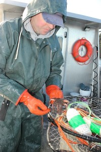
George Stearns (right) and David Winfrey, shellfish biologists for the Puyallup Tribe, count and measure crab caught in a monitoring study in southern Puget Sound.
During the tribe’s early surveys, the sea star population seemed healthy. But, Puyallup tribal scientists recorded a sharp die-off in October. “We saw one monitoring site go from four sea stars per pot in April to 12 in September to zero all together in October,” Stearns said. “We went from catching over 100 sea stars to none within a month at that site.”
“Across the entire area we’re monitoring, we’re seeing a massive decrease in sea star bycatch,” Stearns said. “Some of the sea stars we are finding are literally melting in front of us.”
When a diseased sea star does catch a ride on a tribal crab pot, it deflates quickly. Within a few minutes, a normally rigid sea star will be hanging on the pot like a wet rag.
The main focus of the crab monitoring work by the tribe is to pinpoint exactly when the crab in the tribe’s harvest area molt, or shed their shells.
“Crabbing during the middle of molting, which makes them soft and vulnerable, can increase the handling mortality,” Stearns said. “Its a common practice to shut down harvest during the molt. But, we’ve only had a general idea of when that occurs down here.”
The data collected will also help the fisheries managers put together a more complete picture of crab populations in the South Sound. “We GPS the locations so we’re at the same spots and put the pots in for the same length of time,” Stearns said. “So, we know we’re comparing apples to apples each month.”
Sea star immediately after being caught. Photo by George Stearns.
Sea star five minutes after being caught. Photo by George Stearns.
The U.S. Navy’s aircraft carrier USS John C. Stennis transits the Pacific Ocean alongside the oiler USNS Yukon. | credit: Official U.S. Navy Imagery/Specialist 3rd Class Kenneth Abbate
SEATTLE — The Navy is pursuing permits to continue conducting sonar and explosives exercises in a large area of the Pacific Ocean — and that’s putting marine mammal advocates on high alert.
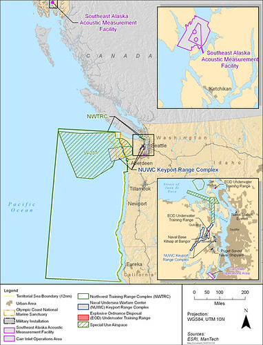
Public hearings kick off next week as the Navy gathers public comments on its draft environmental impact statement for the Northwest training and testing range. The range stretches from northern California to the Canadian border.
Marine mammals, like porpoises, gray and fin whales and endangered orcas, travel through the Navy’s training range. That’s why marine mammal advocates are voicing concerns about the Navy’s activities.
In the draft EIS the Navy outlined plans to conduct up to 100 mid-range active sonar tests each year. That type of sonar has been shown to affect marine mammal behavior.
The Navy also wants to conduct up to 30 bombing exercises per year in the range.
The Northwest training and testing range. Credit: Navy
John Mosher, Northwest Environmental program manager for the U.S. Pacific Fleet, says the training range is critical to naval preparedness.
“At some point realistic training, whether it’s with explosives or sonar, has to take place and they truly are skills that are perishable, things that have to be routinely conducted to be able to do them in case the real need occurs,” Mosher said.
The Navy gathered more than 300 public comments during an earlier scoping phase of its environmental review. Most of those comments centered around impacts on marine mammals.
The Navy has plans in place to look and listen for marine mammals before and during testing exercises. But environmentalists say the mitigation measures are inadequate.
“They’re dropping bombs and you can’t see orcas from the air,” said Howard Garrett of Orca Network. “There’s every real danger that orcas are going to stray into a live bombing range and we don’t want to see that.”
Brad Hanson
The National Oceanic and Atmospheric Administration has been studying the endangered orca population of Puget Sound by tagging orcas and using underwater acoustic monitoring devices to better understand how the whales move through the region. The population of Southern Resident Orcas is hovering around 80 individuals, and has been decreasing in recent years.
Brad Hanson, an expert on orcas with NOAA, says the area within the naval training and testing range is an important forage area for the whales.
“We want to figure out if there are particular areas that the whales are using so the Navy could avoid using those areas for training exercises that might cause any type of harassment of the animals,” he said.
Hanson’s tagging research has shown orcas moving from Washington to northern California within the span of a week.
The body of 3-year-old female Orca L112.
Credit: Cascadia Research
Last year a 3-year-old female orca washed up dead near the mouth of the Columbia River. Her body showed signs of trauma that could have been the result of an explosion but it had been drifting on the Columbia River’s eddies for days, making the results of the necropsy report inconclusive. The official findings were to be released by NOAA Fisheries on Monday.
“It’s probably the most comprehensive necropsy report I’ve ever seen done on a killer whale,” Hanson said.
The Navy also recently announced plans to build a new $15 million dollar facility near Port Angeles, Wash. on the Strait of Juan de Fuca.
What’s Next
Public meetings will be held from 5-8 p.m. for the following dates and locations:
Feb. 26, 5-8 pm: Oak Harbor High School, Oak Harbor, Wash.
Feb. 27, Cascade High School, Everett, Wash.
Feb. 28, North Kitsap High School, Poulsbo, Wash.
March 3, Astoria High School, Astoria, Ore.
March 4, Isaac Newton Magnet School, Newport, Ore.
The deadline for written comments on the Northwest Training and Testing range EIS is March 25.
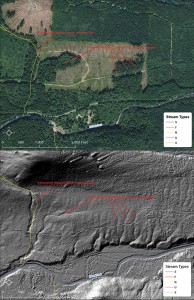
An aerial photo (above) is compared with the LIDAR model.
Source: Northwest Indian Fisheries Commission
The Stillaguamish and Tulalip tribes have partnered with the state Department of Natural Resources and three private timber companies to map forestlands in the Stillaguamish and Skykomish basins.
LIDAR, which stands for Light Distance and Ranging, uses an airborne laser to survey topography.
“The laser pulses from the plane are reflected back to record billions of points of light that measure elevation,” said Derek Marks, Timber/Fish/Wildlife biologist for Tulalip.
Elevation data was collected on working forestlands and a large area of Mount Baker-Snoqualmie National Forest. The result is a high-resolution model that enables natural resources managers to identify resources and potential risks, such as landslides.
“We can save many hours with high-resolution models,” Marks said. “We don’t have to walk the hillside; a forester would have to traverse the area to know where the streams are.”
The new LIDAR surveys covered an area that previously had not been mapped, where the forest canopy covers streams. The models will guide environmental permit reviews for logging and road proposals.
“We’re also reflying the entire North Fork Stillaguamish corridor to compare the data with LIDAR from 2003, to see what’s changed in a 10-year period,” said Scott Rockwell, Timber/Fish/Wildlife biologist for Stillaguamish. Those surveys will cover tribal restoration projects on the North Fork.
“It streamlines management and risk assessment for private industry and state lands,” Rockwell said. “It allows tribes to prioritize and scope restoration projects where we can see obvious habitat potential.”
The surveys were coordinated by the Puget Sound LIDAR Consortium, an informal group of federal and local agencies that acts as a clearinghouse for the high-resolution topographic models, making the data available to the public.
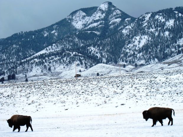
BRETT FRENCH/Gazette Staff Bison wander back toward Yellowstone National Park from outside the park’s northern border in the Gardiner Basin recently. The park continues to ship bison to slaughter to reduce the number of animals in the park.
The Confederated Salish and Kootenai Tribes trucked 17 more Yellowstone National Park bison from the park’s Stephens Creek bison capture facility to a slaughter facility in Ronan on Wednesday.
The tribes pay a game warden to ride along with the shipment of animals to shoot them if there is an accident and the bison escape from the trailer, a requirement of the Montana Department of Livestock.
That requirement was unknown to the Inter Tribal Buffalo Council, which had agreed to take any bison not wanted by Yellowstone treaty tribes. Initially, the DOL offered to provide one of its employees to ride along at a cost of $350 a trip. When the council balked at the cost, Yellowstone on Wednesday agreed to pay, said Christian Mackay, executive officer for the DOL.
“It’s not an insurmountable problem by any means,” Mackay said. “We have some loads scheduled this week to go out.”
Jim Stone, executive director of the buffalo council, said such “annoying” issues are roadblocks to fulfilling agreements under the Interagency Bison Management Plan and he called into question the DOL’s role in the process.
To date, tribal and state hunters have killed 162 bison, said Tom McDonald of the confederated tribes’ natural resources office. The Nez Perce, Shoshone-Bannock and Umatilla tribes are still conducting hunts. Montana-licensed hunters took 29 bison this season.
Last week, the confederated tribes transported another 20 bison from Yellowstone to slaughter and five were transferred to the USDA Animal and Plant Health Inspection Service for research. According to a Park Service spokesman, about 70 to 75 bison are now in the Stephens Creek corral. The bison were not hazed into the facility. Another 50 to 70 bison have moved past the park’s northern boundary in the Gardiner Basin while about 400 have gathered in the park roughly between the towns of Gardiner and Mammoth Hot Springs, Wyo.
Yellowstone officials want to remove 300 to 600 bison in consecutive years to reduce the size of the park’s herds to meet the terms of an agreement with the state of Montana. Bison advocacy groups have decried the move, saying a target population of 3,000 to 3,500 bison in the park is not based on the carrying capacity of the range. This summer the park’s bison herd was estimated at 4,600 animals.
Bison advocates would like to see the animals given more room to roam outside Yellowstone and a quarantine process enacted to transfer live animals to existing tribal bison herds. Those efforts have been fought by the livestock industry since many of the bison carry brucellosis, which can cause pregnant cattle to abort.
Defenders of Wildlife said 56,000 people had emailed Gov. Steve Bullock asking him to intervene and halt the slaughter.
McDonald said confederated tribes are taking bison to slaughter for hunters who were unsuccessful in filling their bison hunting tags. The hunters pay for the cost of shipping, slaughtering and butchering of the bison.
“When it’s all said and done, people love bison meat and are willing to pay a premium,” McDonald said. “Ninety-seven percent of the people who return to eating bison find it exceptional.”
He added that the hunts have been “self-esteem builders” for the parties of hunters that travel to Yellowstone’s borders.
“It’s almost a healing kind of thing,” McDonald said.
A contaminated pile near the community of Red Water Pond Road holds a million cubic yards of waste from the Old Northeast Church Rock Mine. Mark Holm for The New York Times
CHURCH ROCK, N.M. — In this dusty corner of the Navajo reservation, where seven generations of families have been raised among the arroyos and mesas, Bertha Nez is facing the prospect of having to leave her land forever.
The uranium pollution is so bad that it is unsafe for people to live here long term, environmental officials say. Although the uranium mines that once pocked the hillsides were shut down decades ago, mounds of toxic waste are still piled atop the dirt, raising concerns about radioactive dust and runoff.
And as cleanup efforts continue, Ms. Nez and dozens of other residents of the Red Water Pond Road community, who have already had to leave their homes at least twice since 2007 because of the contamination, are now facing a more permanent relocation. Although their village represents only a small sliver of the larger Navajo nation, home to nearly 300,000 people, they are bearing the brunt of the environmental problems.
“It feels like we are being pushed around,” said Ms. Nez, 67, a retired health care worker, who recalled the weeks and months spent in motel rooms in nearby Gallup as crews hauled away radioactive soil from the community’s backyards and roadsides.
“This is where we’re used to being, traditionally, culturally” she said. “Nobody told us it was unsafe. Nobody warned us we would be living all this time with this risk.”
These days, this sprawling reservation, about the size of West Virginia, is considered one of the largest uranium-contaminated areas in United States history, according to officials at the Environmental Protection Agency. The agency has been in the throes of an expansive effort to remove waste from around this tiny and remote Navajo village, and clean up more than 500 abandoned mine areas that dot the reservation.
Federal officials say they have been amazed at the extent of the uranium contamination on the reservation, a vestige of a burst of mining activity here during the Cold War. In every pocket of Navajo country, tribal members have reported finding mines that the agency did not know existed. In some cases, the mines were discovered only after people fell down old shafts.
“It is shocking — it’s all over the reservation,” said Jared Blumenfeld, the E.P.A.’s regional administrator for the Pacific Southwest. “I think everyone, even the Navajos themselves, have been shocked about the number of mines that were both active and abandoned.”
Between 2008 and 2012, federal agencies spent $100 million on the cleanup, according to the E.P.A.; an additional $17 million has been spent by energy companies determined to be responsible for some of the waste.
But the scope of the problem is worse than anyone had thought. The E.P.A. has said that it could take at least eight years to dispose of a huge pile of uranium mine waste that has sat near Red Water Pond Road since the 1980s — waste that must be removed before the area can finally be free of contamination.
“The community is frustrated, I know I’m frustrated — we’d like it to go quickly,” Mr. Blumenfeld said.
But before the latest round of cleanup can begin, an application to remove the waste pile must be submitted to the Nuclear Regulatory Commission, which will then conduct environmental and safety reviews. That process will probably take two years, and there is the possibility that public hearings on the plan could extend the process several more years, said Drew Persinko, a deputy director for the commission.
That time frame seems unreasonably long for tribal members, who said that spending so long living away from the reservation has been difficult. So far, the E.P.A. has spent $1 million on temporary housing for residents of Red Water Pond Road; much of that cost will be reimbursed by General Electric, which acquired the old Northeast Church Rock Mine site in 1997, and also its subsidiary company, United Nuclear Corporation, which operated the mine.
As in the past, the relocations will be voluntary. Some residents wondered — as they have for years now — if the land will ever really be clean.
“Our umbilical cords are buried here, our children’s umbilical cords are buried here. It’s like a homing device,” said Tony Hood, 64, who once worked in the mines and is now a Navajo interpreter for the Indian Medical Center in Gallup. “This is our connection to Mother Earth. We were born here. We will come back here eventually.”
Residents still remember seeing livestock drinking from mine runoff, men using mine materials to build their homes and Navajo children playing in contaminated water that ran through the arroyo. Today, the site near Red Water Pond Road holds one million cubic yards of waste from the Northeast Church Rock Mine, making it the largest and most daunting area of contamination on the reservation.
The waste does not pose any immediate health risk, Mr. Blumenfeld said, but there are concerns about radioactive dust being carried by the wind, runoff from rain, and the area’s accessibility to children, who can slip in easily through a fence.
Under a plan being developed by General Electric and the E.P.A., the waste would be transported to a former uranium mill just off the reservation — already considered a Superfund site — and stored in a fortified repository. The estimated cost is nearly $45 million.
“General Electric and United Nuclear Corporation are committed to continue to work cooperatively with the U.S. government, Navajo Nation, state of New Mexico and local residents to carry out interim cleanups and reach agreement on the remedy for the mine,” said Megan Parker, a spokeswoman for General Electric.
The Navajo E.P.A., which is an arm of the tribe’s own government, for years has been calling for a widespread cleanup of abandoned mines. Stephen Etsitty, the executive director of the agency, said he was hopeful that progress was finally being made, but acknowledged that the scope and technical complexity of the operation at Red Water Pond Road was unprecedented.
“We’re pushing and doing as much as we can to keep the process going as fast as we can,” Mr. Etsitty said. “It’s just taken so long to get there.”
On a recent day, Ms. Nez and several other residents stood on a bluff near a cluster of small homes and traditional Navajo hogan dwellings as the wind whipped across a valley that once bustled with mining activity.
The group talked of their grandparents — medicine men who were alive when the mines first opened — and wondered what they would think about Red Water Pond Road today.
“They would say ‘How did this happen? They ruined our land,’ ” Ms. Nez said. “ ‘How come you haven’t prayed to have this all fixed up?’ ”
A version of this article appears in print on February 20, 2014, on page A10 of the New York edition with the headline: Nestled Amid Toxic Waste, a Navajo Village Faces Losing Its Land Forever. Order Reprints|Today’s Paper|Subscribe
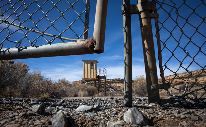
The U.S. Army Corps of Engineers has announced which environmental impacts it will consider in its review of the Millennium Bulk Terminals coal export project in Longview, Wash.
The Millennium project would export 48 million tons of coal a year to Asia. It would ship the coal by rail from Montana and Wyoming to a terminal in Longview, where it would be loaded onto vessels and sent overseas.
In a 12-page memo, the Corps on Tuesday outlined which parts of that process it will consider in reviewing the project’s environmental impacts to the air, water, wildlife and people.
Despite requests from the public to include broader impacts of mining, shipping and burning the coal, the Corps is limiting the scope of its environmental review to the project site.
Washington state recently announced it will include a wider array of environmental impacts in its review of the project.
The decision comes after public agencies collected more than 200,000 comments from the public. Many people asked the Corps to consider the impacts of railroad traffic congestion along the entire delivery route, as well as the pollution created by mining the coal and burning it in power plants overseas.
But in its memo, the agency says:
“Many activities of concern to the public, such as rail traffic, coal mining, shipping coal and burning it overseas are outside the Corps’ responsibility.”
Instead, its environmental review will be limited to the 190-acre project site and the immediate vicinity around Longview. It includes about 50 acres of the Columbia River, where the project would build piers and dredge for ships.
In addition to environmental impacts, the review will also look at the jobs and tax benefits created by the project as well as the demand on public services and utilities.
When the Corps completes its review, the public will be invited to comment on a draft document. A final environmental impact statement will outline what the developer needs to do to offset the impacts of the project.
A $640 million terminal that would eventually export 44 million tons of coal at a private brownfield site near Longview, Wash. It’s a joint venture of Australia’s Ambre Energy and Arch Coal, the second-largest coal producer in the U.S.
Players: Alcoa, Ambre Energy, Arch Coal
Full Capacity: To be reached by 2018
Export Plans: 48.5 million short tons/year
Trains: 16 trains/day (8 full and 8 empty)
Train Cars: 960/day
Vessels: 2/day
What’s Next: On Feb. 12, 2014 the Washington Department of Ecology announced what environmental impacts it will consider in its review of the Millennium Bulk Terminal. In September 2013, U.S. Army Corps of Engineers announced split from what was to be a joint review process. They will conduct a “separate but synchronized environmental review and public scoping process.” The corps’ review will be narrower in scope than that of Washington state. For more information on how to submit comments and to learn details for the public meetings visit the official EIS website.
Typically, due to a lack of direct representation and a diminished voting base, indigenous groups worldwide are subject to exploitation and a corruption of their rights.
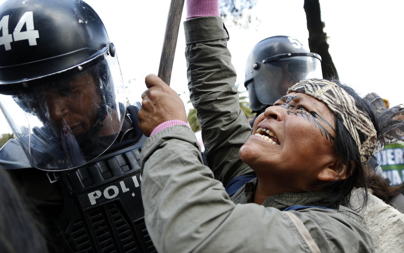
An indigenous woman confronts police guarding the venue where Ecuadorian government officials were meeting with oil company representatives in Quito, Ecuador, Thursday Nov. 28, 2013. Ecuador is looking for private investment to explore oil drilling in its Amazon region and received three bids for oil licensing Wednesday. Indigenous groups from the area are opposed to the government plan. (AP Photo/Dolores Ochoa)
Ecuador’s broken promise to not drill for oil in the territory of several of the nation’s indigenous people has touched off a tribal war and nearly universal condemnation from the international community.
Ecuador, a member of the Organization of Petroleum Exporting Countries, finds itself forced to find new oil sources to satisfy the nation’s ballooning debt to China. The government’s drilling in Yasuni National Park, one of the world’s most ecologically fragile, has been called inexcusable and reckless by locals for the damage it is causing.
Yasuni National Park is home to many species of flora and fauna that exist nowhere else in the world and to several indigenous tribes that have had no contact to the outside world.
A generation ago, the Waorani (also known as the Huaorani, the Waos or the Waodani) — a culturally-isolated indigenous group, started to find its territory challenged by illegal logging. The situation was made worse by American missionaries who worked to moved the Waorani away from its hunting and gathering traditional existence in the rainforest to permanent villages, such as Yawepare, where the Waorani is forced to live in makeshift shacks with no running water or electricity.
This missionary intervention, coordinated by the Ecuadorian government — cleared large blocks of land around the Auca Road for oil extraction. This has led to major contamination of the drilling sites, due to oil and chemical spills under Texaco management. Chevron, which acquired Texaco, was sued by the Yasuni tribes and was ordered to pay $18 billion in 2011 in restitution. Chevron has rejected the judgment and, as Chevron has no active assets in Ecuador, cannot be forced to pay.
This has created a situation in which those who desperately wish to be left alone have grown dangerously even more desperate. The Taromenane, a voluntarily isolated group that violently resisted the missionaries’ attempt to “civilize” them have allegedly increased its attacks on neighboring tribes. While inter-tribal feuds have existed for generations, they have accelerated with the increased presence of outsiders on its tribal lands.
In one cited example, more than 20 Taromenane, mostly women and children, were killed by the Waorani after a Waorani elder and his wife were allegedly killed by the Taromenane. This happened under the supposed protection of the Ecuadorian government. Two Taromenane girls were kidnapped by the Waorani; Ecuadorian officials were only able to recover the eldest girl, with the youngest still in Waorani custody. According to the tribes involved, this is recognized as being in compliance with their traditional mode of justice.
“I protest because it is my home,” said Alicia Cahuiya, a Waorani leader who was invited to speak to the National Assembly after the Assembly voted to open drilling in the Yasuni National Forest.
After Ecuadorian President Rafael Correa won re-election in March, he proposed the opening of drilling in the Yasuni but offered to postpone to leave the oil in the ground if the international community donated the $3.6 billion his country would have lost in revenue. In August, Correa abandoned this plan when only $17 million was donated.
“Yes, there is oil there, but I do not agree with the oil exploitation. We should be consulted about Yasuní. Our elders do not agree with any of this,” Cahuiya said. “Why are the Taromenane tribe people being killed fighting the Huaorani? Because you opened a road into the jungle! We don’t want any of that! Let us live like Waoranis. That is what we want!”
Typically, due to a lack of direct representation and a diminished voting base, indigenous groups worldwide are subject to exploitation and a corruption of their rights. Due to this, many indigenous groups have been hit with rampant poverty, lack of essential services and denial of legal access and protection.
Most items can be recycled today and Tulalip’s Solid Waste and Recycling Departments are in the early stages of a long term goal aimed at a zero waste policy. Within the Tulalip Tribes there are 41 buildings, outside of the administration building, that recycle.
Samuel Davis, the coordinator of Tulalip’s Solid Waste and Recycling Department explains that, “It is important to change the mindset of people and the role they can play when it comes to recycling. I really want us all to be stewards of our environment and to look out for the future of our land and our children.”
Currently, the waste disposal budget for Tulalip is $250,000.00 per year and includes all Tulalip Tribal Government entities, along with tribal members that dump at Shelco. “That number is too high so we are trying to find ways, through recycling and other avenues, to lower the amount of waste we send to our land-fills,” Davis states.
While there are multiple locations throughout the admin building to toss recyclables, Davis said they were noticing the bins were not being used as much as they should have been and that a majority of the garbage being hauled out was filled with recyclable items. So, they decided to put a recycling bin at every desk to make it that much simpler for everyone to recycle.
“One of our next steps is to start an educational program on what can be recycled and just how important it is to recycle,” said Davis. Since most items can be recycled, the other issue is the item should be clean when it is tossed into the recycling. The cleaner the container, the more it is worth in the recyclables market. Most recycling facilities sort items by type (paper, plastic, glass, metal) and then by quality. When an item is of poor quality the facility must do more work to get the item in usable shape.
Providing a clean or near clean recyclable item can save money for the city and taxpayers. But, how clean is clean? The container does not need to be squeaky clean, just without food is acceptable. An example would be a finished yogurt cup; the yogurt has been all scooped out and can be tossed in the bin but if you were to lightly rinse out the container that will make it better quality.
The white paper cups provided at the admin building and at nearly every coffee stand are not recyclable. This information had me personally reconsidering what I use to eat my morning oatmeal. The cups have an inner plastic coating that keeps the paper from absorbing liquids but makes the cup very difficult to recycle. Although the white cups are not recyclable the Styrofoam provided at the admin is. Davis explains, “Styrene foam (Styrofoam) is ground up, compressed and densified into blocks, which are then manufactured into plastic products such as picture frames, TV & computer cases, office equipment and other plastic products. There are only a few companies in the area that do recycle Styrofoam and we are in the process of working with them to get bins for that purpose.”
At the admin, if everyone brought in their own reusable containers, coffee cups and water bottles this would reduce the amount of waste hauled out, which is not only good for the Tribe’s budget but also the environment. Check the Waste Management website at www.wmnorthwest.com for more detailed information about recycling do’s and don’ts.
While most items can be recycled here is a list of items that can’t be recycled: soiled paper, soiled cardboard, wrapping paper, laminated paper, paper covered in foil, frozen-food boxes, blueprints, thermal fax paper, pet food bags and dryer sheets.
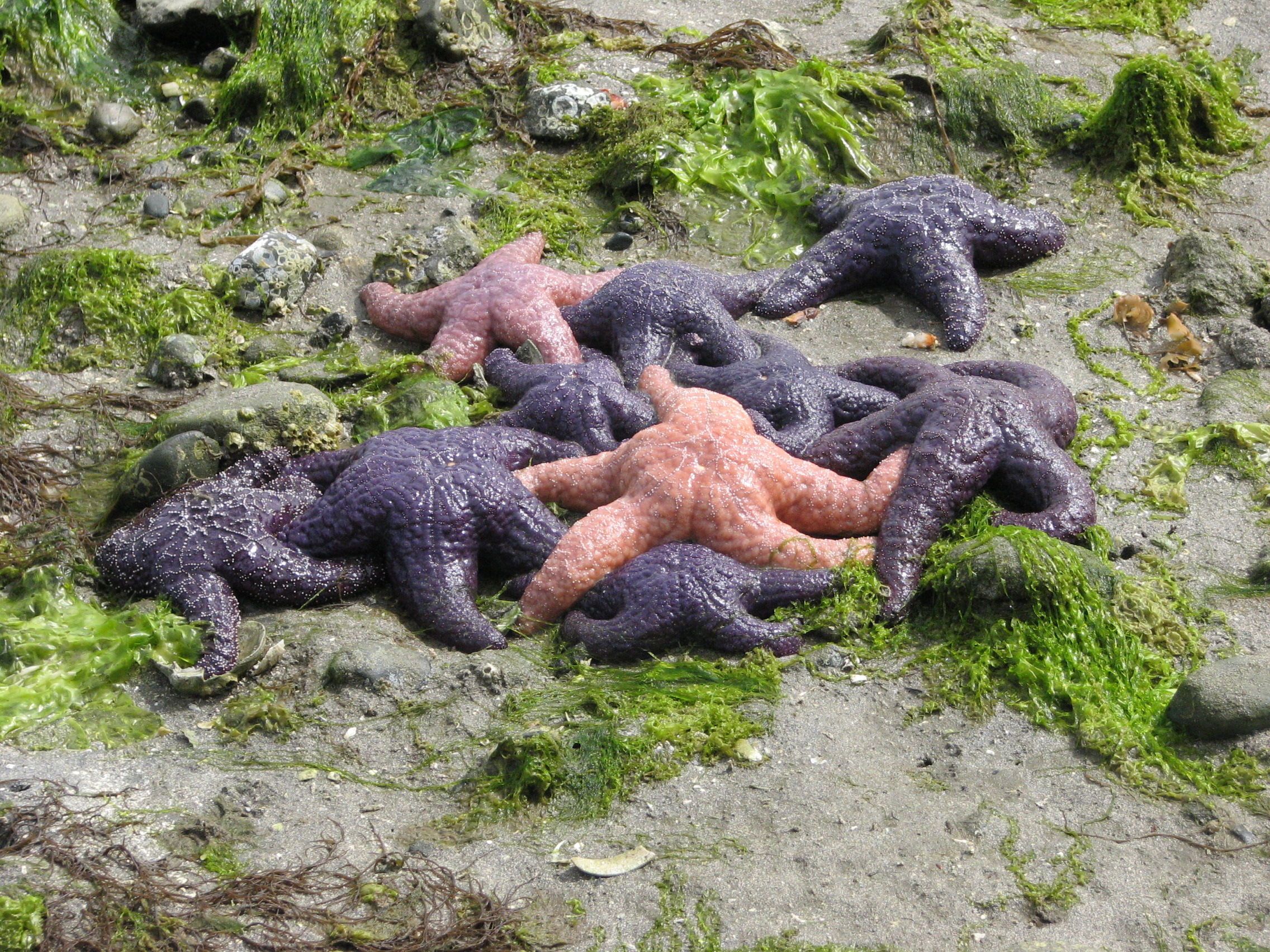
MUKILTEO — It’s an iconic summertime image in the Northwest: children playing on the shoreline at low tide, shoveling sand into plastic pails while purple and orange sea stars cling to exposed rocks nearby.
On some beaches this summer, that scene likely will be missing the sea stars.
A mysterious condition is killing sea stars — commonly known as starfish — by the thousands all along the Pacific Coast of North America, from Alaska to Baja California.
The ochre sea star, the colorful type often seen clinging to those rocks, is one of the hardest-hit species, said Drew Harvell, a Cornell University biology professor working on the problem for the University of Washington’s Friday Harbor Laboratories.
Sea stars, she said, “are emblematic; people have them on their T-shirts, for heaven’s sake.”
Local populations in the inland waters of Western Washington — including in Mukilteo and Edmonds — have been nearly wiped out just in the past few months, researchers and divers say.
The stars are turning to jelly and disintegrating. A group of researchers is working to find out why.
“It’s extremely difficult to pinpoint the exact cause,” said Ben Miner, an associate professor of biology at Western Washington University in Bellingham.
He recently collected samples of sick and dead sea stars in Mukilteo and Edmonds.
The prevailing theory so far, Harvell said, is that the deaths are being caused by a pathogen, bacteria or a virus, as opposed to a broader environmental condition such as ocean acidification.
Other types of organisms are not experiencing similar death rates, she said. The scourge has been more pronounced in inland waters than on the outer coast.
Populations in Oregon, compared to those in Washington and California, have mostly been spared.
Some inland waters have been hit hard by the die-off, while other areas, such as the harbors at Langley and Coupeville on Whidbey Island, still have healthy populations, Miner said.
Sea stars that live in ultraviolet-light-filtered water in aquariums are mostly healthy, while those that live in unfiltered water are more often showing signs of disease, Miner said.
While the evidence so far points to a pathogen, “that certainly doesn’t preclude the possibility that there are other things in the water that are weakening their immune systems and allowing them to get sick,” Miner said. “It has the potential to be a combination.”
If it is bacteria or a virus, it’s uncertain whether humans are contributing to the problem, Harvell said.
“Once we know what it is, we’ll have a much better idea of what the answer to that is,” she said.
Another theory is that the condition is caused by radiation that has drifted across the ocean from the nuclear power plant in Fukushima, Japan, which suffered a meltdown after the March 2011 earthquake and tsunami.
If that were true, many more creatures would be affected, researchers said.
“It’s unlikely to be the direct cause,” Miner said.
There are several hundred species of sea stars worldwide and about 25 in the Pacific Northwest, he said.
“About half of those species appear susceptible,” Miner said.
Large “sunflower” stars, which have up to 20 arms and can be more than 3 feet across, have taken the brunt of the plague along with the ochre stars, Harvell said.
Kimber Chard, of Edmonds, a scuba diver who frequents the waters of Edmonds and Mukilteo, said he began noticing dying sea stars about nine months ago.
“The sunflower stars used to be everywhere,” Chard said. He used to see up to 30 of them per dive. Now it’s down to two or three.
“There used to be so many of them, and they’re just so few.”
Sea stars are echinoderms, in the same phylum as sea urchins, sand dollars and sea cucumbers. Sea stars are voracious eaters, sucking down clams, mussels, barnacles, snails, other echinoderms and even each other, researchers said. As a result, their losses could send big shock waves through the food chain.
Scientists at universities along the West Coast and at Cornell in Ithaca, N.Y., have teamed with aquariums and divers to work on the problem.
Miner is placing healthy sea stars in tanks with sickly ones to test the contagiousness of the condition. Samples of sick stars are being tested at a marine lab on Marrowstone Island near Port Townsend. Some are frozen, preserved and sent to Cornell researcher Ian Hewson.
“He has the capability to test for bacteria and viruses and he’s worked incredibly hard all fall,” Harvell said.
Miner said he hopes to have some study results to report within a couple of months.
“We’re just watching which way it goes and how fast it goes,” he said.
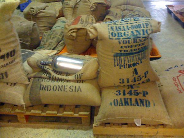
Between disputes—even wars—over land rights to the fight for a fair wage, there is no doubt that the coffee industry affects the lives of indigenous people wherever coffee is grown. This is especially true here in Central America where coffee is one of the developing world’s biggest exports. Compacting the affect of coffee on indigenous communities is the threat to their land. Rainforests are cut down to make fields for the coffee while water is contaminated by chemical run offs from herbicides and the curing process. As indigenous people, what can we do to support our brothers and sisters in the Coffee Belt? Well, we can start by buying coffee with ethics but just what do all the labels and certifications mean? Here are four of the most commonly used certifications for coffee and a quick run down of what exactly they stand for:
Rainforest Alliance Certification (RAC)
Created to help combat the destruction of the rainforest, coffee is just one of many products that the Rainforest Alliance certifies. Their environmental standards call for 70 trees (at least 12 must be native species) per 2.5 acres, no altering of natural watercourses, no trafficking of wild animals or irresponsible dumping of hazardous waste.
Children under 15 cannot be hired under the RAC, and coffee farmers are expected to take steps to allow minors to continue their education. However, unless the label reads 100% RAC, as little as 30% of the beans in your bag of coffee may actually be RAC. The origin and growing practices of the other 70% is anybody’s guess.
Organic
Unlike the RAC, at least 95% of the beans in a bag of coffee must meat the USDA’s organic standards to be labeled as organic. These standards prohibit the use of synthetic substances like herbicides and pesticides. While most synthetic substances rarely make it to the consumer (they are either washed off in the processing or burnt off in the roasting) these standards do help the environment and increase the quality of the air, water, and soil that the workers are working in.
Fair Trade
The Fair Trade initiative began as a way to establish a minimum price on a pound of coffee. It’s been estimated that as little as 1 cent of each pound of coffee sold goes to the worker who picked the coffee, and less than copy to the farmer who grew it. As of April 11, 2011, Fair Trade certified coffee guarantees the farmer a price of copy.40 a pound, or copy.70 if it is organic—which still seems like chump change when compared to the copy2-copy6 you will spend on that same pound of coffee. However, the Fair Trade organization also ensures that some of that extra money trickles down to the coffee pickers in the form of a set minimum wage.
Under the Fair Trade label, farmers must follow sustainable practices for disposing of hazardous waste as well as maintain buffer zones around bodies of water to prevent contamination. Water and soil conservation is also stressed.
Shade-Grown Coffee
Shade-grown coffee is simply coffee that has been grown in the shade—under a tree canopy. There are a couple of benefits to shade-grown coffee: first, many swear that it tastes better. After all, it is the traditional way that coffee has been grown. Second, shade-grown coffee is better for the environment because it prevents a monoculture of coffee from occurring. Instead of having acres and acres of just coffee, every few feet a shade tree is planted. This helps cut back on diseases that monocultures are vulnerable too, it’s better for the soil (less erosion) and it encourages birds and other animals to inhabit the area.
However, there is no government or third party certification for shade-grown coffee. Essentially any producer or seller could slap the term “shade-grown” onto their coffee even if it’s not true. Therefore, you can never be sure how exactly your coffee was grown.
Darla Antoine is an enrolled member of the Okanagan Indian Band in British Columbia and grew up in Eastern Washington State. For three years, she worked as a newspaper reporter in the Midwest, reporting on issues relevant to the Native and Hispanic communities, and most recently served as a producer for Native America Calling. In 2011, she moved to Costa Rica, where she currently lives with her husband and their infant son. She lives on an organic and sustainable farm in the “cloud forest”—the highlands of Costa Rica, 9,000 feet above sea level. Due to the high elevation, the conditions for farming and gardening are similar to that of the Pacific Northwest—cold and rainy for most of the year with a short growing season. Antoine has an herb garden, green house, a bee hive, cows, a goat, and two trout ponds stocked with hundreds of rainbow trout.