Without surprise, the National Energy Board has approved the reversal of the Line 9 pipeline. This pipeline crosses every single tributary that flows into Lake Ontario, and cuts up the north shore of the St. Lawrence river….
It was anticipated that this information be released on March. 19th. Instead the rubber-stamping came early.
Indigenous peoples whose territories are being attacked by this project have been silenced throughout this process. It is our communities, and other communities of colour, who primarily live fenceline with the tar sands, its mining, infrastructure and refineries. It is our Sacred sites that are being desecrated by the shady movements of corporate imperialists and colonial-capitalists.
Line 9 shows us exactly what environmental racism looks like, from Aamjiwnaang to Jane & Finch – telling us that bodies of colour and Indigenous bodies are expendable for the larger project of profit. Line 9 is but expanded infrastructure to move the Athabasca tar sands eastward – it is an embodiment of the slow industrial genocide that is being committed by TransCanada, Enbridge, Suncor, and the Government of Canada, to name a few.
This deep rooted social disconnection from the land is fostered by the occupation of our Nations’ territories. The attack on Indigenous bodies and bodies of colour are but a glimpse into the functions of this White supremacist, settler-colonial death culture that seeks to consume, corrupt and conquer.
On March 19th, let us keep close the truth of the violence that is this pipeline: an apparatus of tar sands destruction that seeks to poison that which sustains us and those faces not yet born. On this day we will be connected with each other in struggle as we fill our hearts with love for the wild and carry inside us a hunger for justice. March 19th Take Action Against Line 9!
We are requesting solidarity actions by friends in struggle who share Enbridge as a common enemy – from the West to the East, Enbridge’s toxic tendrils are an affront on Indigenous Sovereignty and the health of all of Creation.
—
Only you, your community and your affinity groups know what action is best to take in your area. Get in touch with us if you want to confirm an action. #Line9IndustrialGenocide
Be safe, be strong!
Keep your ear to the ground, because there are more battles ahead. Stop the beast! #NoLine9 #NoEnergyEast
Note: For more background on Enbridge’s Line 9 tar sands pipeline and the recent approval it received by Canadian regulators, click here.
Lakota members marched during the annual Liberation Day commemoration of the Wounded Knee massacre. People carried American Indian Movement flags and shot rifles into the air as part of the celebration. Photo: Deep Roots United Front/Victor Puertas
On February 27, Oglala Lakota and American Indian Movement activists joined in a four-directions walk to commemorate Liberation Day, an event to mark the 1890 massacre at Wounded Knee. As they do each year, four groups gather to the north, south, east and west and then walk eight miles until converging on top of Wounded Knee, where they honor the fallen warriors and the tribe’s rich history of resistance.
“It is an acknowledgement of the resiliency of who we are as a people,” explains Andrew Iron Shell, an organizer and activist of the Sicangu Lakota Nation. “It gives permission and courage for our up-and-coming generations to face the challenges of their time.”
The history of the occupation began with a massacre more than 100 years ago. On a cold day in December 1890, the United States army killed 300 Lakota men, women and children in a massive shoot out after a member of the First Nations refused to give up his arms. It marked the first bloodshed on Wounded Knee – although there had been many massacres of First Nations people by the colonialists before it. The event was also considered the end of the Indian Wars.
Eighty-threeyears later, on Feb. 27, 1973, about 200 Lakota members took siege of the town of Wounded Knee. Reclaiming a location that was written in the history books as a place of defeat, the Lakota stood their ground. They were there in protest of a failed attempt at impeaching the tribal president at the time, Richard Wilson, who was known to be corrupt and abusive. Initially a protest against the tribal government, the occupation took a turn when U.S. police forces arrived. The protestors switched the occupation’s focus to the United States’ frequent violation of treaties.
The armed warriors maintained control over the town for 71 days while the FBI encircled them. At the final standoff, two warriors were killed, about 12 people were wounded and over 400 were arrested. The Oglala were able to harness national attention through their occupation, using the spotlight to question the United States’ treatment of First Nations people.
As history passed, later generations rarely heard about the occupation of Wounded Knee — or about first nation people at all. This skewed national memory should be unsurprising: When you have a society and a nation built upon the subjugation of people of color, you can expect nothing more than the constant erasing of certain histories.
Ongoing genocide
I recently visited Prisoner of War Camp 344, also known as the Pine Ridge Indian Reservation. It wasn’t my first time in the sovereign Oglala Sioux Nation, but it was my first time joining in the ceremonies celebrating the 41st annual Liberation Day to remember the 1890 reoccupation of Wounded Knee.
The vibrant American Indian Movement flags waving in the harsh South Dakota winter wind reminded me of the old black and white photos I used to see in my history books. The Lakota would not disappear without a fight, regardless of what the United States’ intentions were. Children walked alongside elders who had taken part in the occupation, showing clearly the group’s intergenerational wisdom. These are children who are stripped of learning their people’s history in schools, but instead learn it through stories and dances. They are children who live in a sovereign nation that contains two of the poorest counties in the United States and who recognize the threats their families face every day.
One of these threats come from the so-called town of White Clay, Neb., where visitors can witness the way violence against the First Nations people has changed — but not disappeared — over the generations. Consisting of only 12 people and four liquor stores, White Clay was once part of a 50-square-mile buffer that prevented alcohol from entering the reservation. In 1904, President Roosevelt signed an executive order that removed 49 of those square miles. Since then, the town’s economy has been driven by the $4 million in alcohol sales to the people of the Pine Ridge Indian Reservation. There is no legal place to drink in or around White Clay: Alcohol containers can’t be opened on the property of the distributor, it’s prohibited to drink in the street, and the reservation is dry territory. Yet, somehow, the town of 12 people manages to keep four liquor stores open. Barely two miles from the reservation’s epicenter, and less than 200 feet from the dry reservation line, the town perpetrates a type of violence that is, on the reservation, known as liquid genocide.
The reason for this name becomes apparent when one examines the teenage suicide rate on the reservation, which is 150 percent higher than the U.S. national average for this age group. Many attribute this death rate to the sale of alcohol to minors, which White Clay store owners are known to do. The liquor stores also break the law by selling to intoxicated people, and by trading alcohol for pornography, sexual favors — including from minors — and welfare checks. The effects of free-flowing alcohol are devastating: On the reservation, 90 percent of all court cases are related to alcohol use.
Kate, a Tokala warrior, believes that alcoholism is part of a larger problem of the disappearance of indigenous culture. For her, the only way to live in the geographical region of Pine Ridge is the indigenous way. “We are the ones on the back roads, still chopping wood. We are living the way we used to live,” she said. “It’s not hardship; it’s the way it’s supposed to be.”
Kate and many others know that alcohol was introduced to her people as a means to steal from them. Living deeply connected to the history of their nation, they believe that if they shake free of the colonized mindset, alcohol wouldn’t even be an issue.
Threats to the land
In addition to trying to close down White Clay, the Oglala Lakota Nation is actively fighting the construction of the Keystone XL pipeline. This 1,700-mile pipeline, which would carry 830,000 barrels of crude oil each day from western Canada through South Dakota en route to Texas. At two points it would even intersect with a pipeline that serves as a main water source for the Sioux Nation, affecting all of the Pine Ridge reservation as well as the nearby Rosebud reservation.
Advocates for the pipeline argue the pipeline is the safest way to transport crude oil. TransCanada, the company in charge of the pipeline, predicted that the first Keystone pipeline, which runs from Alberta to Illinois, would spill once every seven years. During its first year in operation, it spilled 12 times. The Lakota, along with other First Nations, have vowed to use direct action to stop construction of the pipeline.
For a nation whose land and sovereignty has been threatened for hundreds of years by U.S. politics, the Keystone XL pipeline is part of a long history of threats to the Lakota Nation – and to the earth itself.
“They want to get rid of the Lakota, the protectors of the earth,” said Olowan Martinez, an organizer in the Lakota community. “But what they don’t know is when they get rid of the Lakota, the earth isn’t too far behind. Our people believe the Lakota is the earth.”
President Obama is scheduled to be make a final decision on the pipeline by the middle of 2014. While the Lakota are hoping he will not approve the project, they are also getting ready to stand up and fight. During the Liberation Day celebrations, the Lakota’s dances and stories relayed messages about sacred water and Mother Earth. The tribe has also united with other First Nations to organize a three-day direct action training called Moccasins on the Ground, which was designed to prepare people to act if the pipeline is approved.
“Dead or in prison before we allow the Keystone XL pipeline to pass,” the Lakota warriors, many mounted atop horses, repeated during the Liberation Day celebration. Their words carried the weight of 521 years, and counting, of lived resistance.
PUYALLUP – The Puyallup Tribe of Indians working to decrease sediment in Clarks Creek, an important salmon tributary to the Puyallup River.
“Clarks Creek is important because it supports several different species of salmon, some listed under the federal Endangered Species Act,” said Char Naylor, water quality program manager for the tribe. Clarks Creek also supports the highest salmon spawning densities in the Puyallup watershed as well as the most significant number and variety of spawning salmon within a city limits in the watershed.
“Its also important because it can be an example of how we can restore hundreds of small urban streams in Puget Sound,” Naylor said. The problems facing the Clarks Creek watershed are endemic to most Puget Sound lowland streams. The principal non-point pollutants causing degradation are excessive sediment, nuisance weed growth, nutrient enrichment and excessive bacteria loading.
“If we can tackle these issues in Clarks Creek, we can show other Puget Sound communities how to heal their streams,” Naylor said.
The tribe is leading a regional effort to clean up the creek by reducing the amount of sediment flowing into it. Too much sediment in a stream drives down salmon productivity because it impacts the fish’s ability to find clean spawning gravel in which to spawn or rear. The goal of the project is to reduce sediment loads by half and nutrient and bacteria by a third by lowering flows and stabilizing banks to reducing channel erosion.
The tribe recently finished a two-year study of sediment sources throughout Clarks Creek. The study found that if 23 major sources of sediment were repaired, over 50 percent of the creek’s sediment problem would go away. Yet by doing just the top eight bank stabilization projects, a huge amount of sediment can be removed from the stream very cost-effectively.
The tribe is putting together plans to restore two those major sources of sediment in the creek. The tribal projects would stabilize the banks of two Clarks Creek tributaries. “We would literally be changing the shapes of their banks and channels, adding gravel and planting vegetation along their banks,” Naylor said.
Other sorts of projects suggested by the study include stormwater retrofits, low impact development, and stormwater detention ponds.
Most of the creek’s sediment actually start with the river it flows into. “The Puyallup River is diked through most of its lower reach,” Naylor said. “This caused the river bed itself to drop, which means the creeks flowing into it also drop.” This down-cutting action puts more sediment into the creek than would be there otherwise.
Clarks Creek is just 4 miles long and flows through suburban neighborhoods of the city of Puyallup before joining the Puyallup River. Because it is largely spring-fed, the creek has a consistent level of water throughout the year, making it great rearing habitat for juvenile salmon. The Puyallup Tribe also operates a chinook hatchery on the creek.
“We have already begun working on implementing several of the identified sediment projects to restore the watershed almost before the ink was dry on the report,,” Naylor said. “It is satisfying to have changed the status quo, the way things have been done in this watershed over the last several decades.”
UV vision help reindeers find plants in snow cover, but in the depths of winter their wide irises and sensitive eyes means the power lines appear particularly bright. Photo: Mark Bryan Makela/Corbis
By Damian Carrington, March 11, 2014. Source: The Guardian
Power lines are seen as glowing and flashing bands across the sky by many animals, research has revealed.
The work suggests that the pylons and wires that stretch across many landscapes are having a worldwide impact on wildlife.
Scientists knew many creatures avoid power lines but the reason why was mysterious as they are not impassable physical barriers. Now, a new understanding of just how many species can see the ultraviolet light – which is invisible to humans – has revealed the major visual impact of the power lines.
“It was a big surprise but we now think the majority of animals can see UV light,” said Professor Glen Jeffery, a vision expert at University College London. “There is no reason why this phenomenon is not occuring around the world.”
Dr Nicolas Tyler, an ecologist at UIT The Arctic University of Norway and another member of the research team, said: “The flashes occur at random in time and space, so the power lines are not grey and passive, but seen as lines of light flashing.”
He said the discovery has global significance: “The loss and fragmentation of habitat by infrastructure is the principle global threat to biodiversity – it is absolutely major. Roads have always got particular attention but this will push power lines right up the list of offenders.” The avoidance of power lines can interfere with migration routes, breeding grounds and grazing for both animals and birds.
Autopsies on dozens of mammals from zoos and abbatoirs showed their eyes were able to see UV, including cattle, cats, dogs, rats, bats, okapi, red pandas and hedgehogs. Also on the list were reindeer and further work published in the journal Conservation Biology showed these animals, whose eyes are specially adapted to the dark Arctic winters, are particularly sensitive to UV light. UV vision helps reindeer find plants in snow cover, but in the depths of winter their wide irises and sensitive eyes means the power lines appear particularly bright.
The avoidance of power lines had been explained in the past by the corridors cut through forests to accomodate them, where animals would be exposed in the open to predators.
But this explanation could not apply in the treeless tundra of northern Norway, where 220,000 reindeer are tended by 7,000 herders from the traditional Sami people. “Right now, there is a plan to build a 186-mile long power line in north Norway,” said Tyler. “This new work will encourage power companies to negotiate with herders about where they put the power lines.”
Around the world, Tyler said: “There are hundred of examples of animals avoiding power lines. Now we know that, not only do these clear-cut corridors mean exposure to predators, at the same time there is this damn thing flashing at you.”
Jeffery said burying all power cables would be unrealistically expensive but added that one idea would be to put a non-conducting shield around the cable to screen it from view. The UV light, which is caused by electricity ionising the air around cables, are a major source of inefficiency for electricity companies and also cause the hissing or crackling noises sometimes heard.
Power companies already use helicopter-mounted UV cameras to monitor power cables, because the flashes can be an early sign of conduction problems, but the cameras only record a very narrow range of UV. “Animals see across the range, so the intensity of light seen by them is much more than seen by the helicopter flights,” said Jeffery.
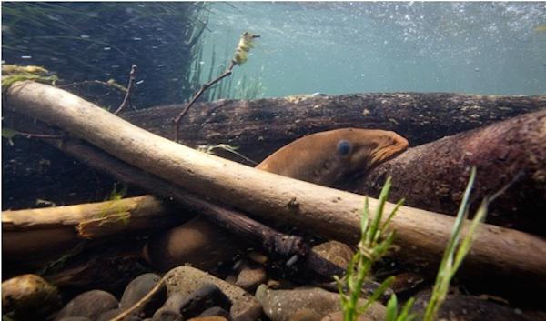
U.S. Fish and Wildlife Service The Pacific lamprey
Indian Country Today Media Network
The Pacific lamprey, culturally significant to the Umatilla and other tribes, now has a shot at making it past the McNary Dam to spawn.
The U.S. Army Corps of Engineers is supplementing the fish ladder of the dam’s Oregon shore with an additional structure that offers water velocities more conducive to lamprey migration, the Union-Bulletin reported on March 8.
The structure would allow lampreys, which tend to move along the river bottom in water that flows more slowly than the upper levels preferred by spawning salmon and steelhead, to access the fish ladder and make it upstream, the Union-Bulletin said.
“We plan to conduct video monitoring to observe which velocity is preferred by migrating lampreys,” said Mark Smith, who managed the project for the Corps, to the newspaper. “We anticipate this prototype structure will help us learn quite a bit about what’s best for lamprey passage.”
Lampreys have been around for at least 450 million years, the oldest fish in the Columbia River system, according to the Columbia River Inter-Tribal Fish Commission (CRITFC). Though not in danger of extinction, they have declined from a former high of millions 30 years ago to just about 4,000 returning to the Snake, Clearwater and Salmon river drainages where they once teemed, said Aaron Jackson, lamprey project leader for the Confederated Tribes of the Umatilla Indian Reservation, to the Union-Bulletin.
Tribes in the Pacific Northwest use the lamprey for food and medicine, and the fish plays a key role in regulating inland aquatic systems. They spend their first four to seven years of life acting as filters in freshwater sand and silt, then move to the ocean where they become parasites, latching onto various saltwater prey, the Union-Bulletin said. After two to three years of that they return to their freshwater origins to spawn.
The Army Corps of Engineers work group that helped design and engineer the structure included tribal representatives, the newspaper said. Built by Marine Industrial Construction of Wilsonville, Oregon under a $336,542 contract, was completed in late February and is the first such installation in the mid-Columbia River, the Union-Bulletin said.
“We’re excited to see something like this put in the river,” Jackson said.
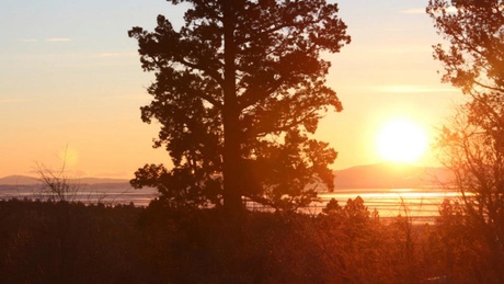
The Klamath Basin spans northern California and southern Oregon and has seen frequent water crises between the farming, ranching, tribal and environmental communities. | credit: Devan Schwartz
An agreement announced Wednesday between ranchers and Native American tribes seeks to resolve contentious water rights issues in the Klamath Basin, a drought-ridden region spanning southern Oregon and northern California.
Amidst a deep drought last summer, the Klamath Tribes and the federal government called on their senior water rights –- meaning they received access to limited water supplies.
As a result, irrigation water was cut off to thousands of acres of Klamath Basin ranchland. This created millions of dollars in losses.
The new agreement seeks reduced water demand by ranchers, along with increased river restoration and economic development for the Klamath Tribes.
Tribal chairman Don Gentry said it wasn’t easy getting all the stakeholders in the Klamath Basin to reach common cause on such a contentious issue.
“It’s nothing short of remarkable that we’ve come to this point,” he said.
Last summer, Larry Nicholson saw irrigation water shut off to his family’s cattle ranch. He hopes that won’t happen again.
“Everybody can have water, where most people couldn’t before,” Nicholson said.
Proponents of the new agreement say it will bring stability to the region and represents an important step forward in a generations-long struggle.
But some conservation groups disagree.
Jim McCarthy of Oregon WaterWatch said the agreement doesn’t go far enough in limiting the amount of water that people will want to withdraw — water that others want to remain in streams to help fish and wildlife . “It’s just not enough water to solve those problems,” he said.
Drought conditions could be worse next summer and fall than they were in 2013. The Klamath Basin currently has a snowpack about 40 percent below what it was last year at this time, according to Natural Resources Conservation Services data.
The new agreement calls for an additional 30,000 acre-feet of water to help fill Upper Klamath Lake –- the source for both the Klamath River and the Klamath Project, one of the largest federal agricultural projects in the country.
This would be accomplished through a combination of reduced ranching through a land retirement program and increased management of streamside areas along Upper Klamath Lake tributaries.
As far as economic development, an additional $40 million would be appropriated for the Klamath Tribes.
Tribal Chairman Don Gentry said this agreement is historic and paves the way for a better economic situation for the Klamath Tribes, in addition to better protecting the natural resources of historic tribal lands.
The new agreement still faces votes by the ranching and tribal communities, and would be folded into federal legislation that is likely to reach opposition in a divided congress.
The legislation would combine the Klamath Basin Restoration Agreement and the Klamath Hydroelectric Settlement Agreement, which stipulates the removal of four hydroelectric dams from the Klamath River.
But Gov. Kitzhaber’s natural resources advisor Richard Whitman expressed confidence that the continued leadership of Sen. Ron Wyden could get the bill approved in Congress by the end of the year -– and help solve the water crises in the Klamath Basin.
PORT ANGELES, Wash. — Anne Shaffer sits on the sandy shoreline of the Elwha River and looks around in amazement. Just two years ago, this area would have been under about 20 feet of water.
So far about 3 million cubic yards of sediment — enough to fill about 300,000 dump trucks — has been released from the giant bathtubs of sediment that formed behind the two hydroelectric dams upstream. And that’s only 16 percent of what’s expected to be delivered downstream in the next five years.
All of that sediment is already reshaping the mouth of the Elwha, which empties into the Strait of Juan de Fuca on the northern shore of Washington’s Olympic Peninsula.
The depth at the mouth of the river has changed by about 50 feet. Long, charcoal-colored sandy beaches have formed where there once only smooth, platter-sized cobblestones.
Watchvideo report:
“This place is like Christmas,” says Shaffer, a marine biologist and the executive director of the Coastal Watershed Institute. “Everyday you come out here and its something new.”
Shaffer is leading a team of researchers who are studying the Elwha’s nearshore area, where the river’s freshwater meets the saltwater tides. Shaffer explains that until recently this area was starved of sediment, and now a whole new ecosystem is forming. Her team is trying to find out what tiny creatures are moving in.
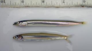
They’re searching for evidence that species like sand lance and surf smelt are using this area as spawning grounds. These tiny fish are a common food sources for juvenile salmon.
Sand lance (top) and surf smelt (bottom) by David Ayers/USGS.
Sand lance, she explained, require a very fine grain sediment in order to lay their eggs.
“We now are surrounded by the exact grain size that sand lance need to spawn,” she says.
The team scoops up bags of sand to test in the lab. So far they haven’t found evidence of sand lance spawning in this new habitat, Shaffer says. But they have found that surf smelt are spawning in areas where sandy substrate has built up.
During recent fish census surveys of the Elwha’s estuary, Shaffer’s team counted baby chum salmon in numbers they haven’t seen in years, if ever, Shaffer said. And they’ve also found a number of eulachon, a type of smelt that was once an abundant food source for coastal tribes. The eulachon is now listed as threatened under the Endangered Species Act.
“As soon as this habitat is available, these fish are using it,” Shaffer says. “None of us anticipated how quickly it would occur. I’d never seen a eulachon in the estuary before, but in the last three months, every time we survey, we see them.”
The drone of a single-engine plane causes Shaffer to look up and shield her eyes.
“I bet that’s Tom,” she says with a smile.
A Bird’s Eye View
Port Angeles pilot and photographer Tom Roorda has had one of the most unique perspectives during the last two and a half years while the dams have been slowly dismantled. He started taking land-survey photos of the Elwha eight years ago. Back then his photos were used to help the federal Bureau of Reclamation prepare for dam removal.
Today his jaw-dropping aerial photos capture the giant plume of sediment flowing out of the mouth of the Elwha.
“Until I started taking these pictures, no one had any idea how much sediment was coming down or how far it extended out into the strait,” Roorda said.
The flush of sediment has moved the mouth of the Elwha north by about 300 feet, creating a long skinny spit that extends into the Strait of Juan de Fuca. The area that used to serve as the Elwha’s estuary has been inundated with freshwater and a new estuary is forming downstream.
“As soon as it starts to rain that sediment gets washed down into the river and we get these big gulps of sediment coming down,” Roorda said.
This winter’s rains have continued to flush sediment downstream, so much so that the river’s flow is currently 10 times higher than normal. While all that sediment is ideal for building nearshore habitat, some worry the water will be too murky for salmon. Sediment can clog and irritate their gills and make it difficult to find food.
But Shaffer for one, isn’t concerned.
“Salmon are brilliant,” she said. “They have evolved over millenia. If they’re given a chance to acclimate to it, they will.”
The First Leap?
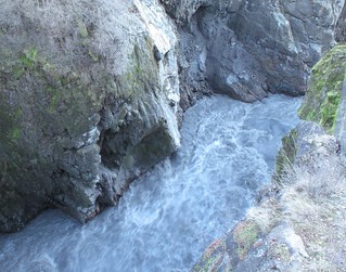
Today the entire length of Elwha looks like a free-flowing river. That’s because recent storms have submerged the remaining 25 or so feet of the Glines Canyon Dam.
Glines Canyon Dam, March 10, 2014, Olympic National Park
From webcam images, it’s difficult to even identify the slope of what remains of the 210-foot spillway. This is causing some to wonder how much longer it will be before the first fish leap over the concrete barrier that remains.
It may take weeks or months, but when the first leap happens, it’s not likely to be a salmon.
“Steelhead are quite the athletes. A steelhead can leap up to 12 feet in a single jump,” said John McMillan, a NOAA biologist who is tracking fish recovery on the Elwha.
McMillan is betting on steelhead — trout that, like salmon, are born in freshwater streams before migrate to marine waters. He says he’s seen steelhead ascend a 35-foot cascading waterfall by taking a series of long leaps.
Researchers are using imaging sonar to track the different fish returning to the Elwha, and they’ve found that some steelhead have already returned to the lower Elwha, McMillan said. The bulk of the run, however, is expected to take place from April to early July, he said.
Dam deconstruction will pause May 1 to minimize disruption to the steelhead spawning season.
Removal of the Lower Elwha Dam finished in March 2012. The last of the rubble of the Glines Canyon dam is expected to be gone by September 2014.
Brian Lipscomb, the CEO of Energy Keepers, announced this week that that the Confederated Salish and Kootenai Tribes would acquire Kerr Dam for $18.3 million – more than the $14.7 million the tribes wanted to pay, but more than $30 million less than what PPL Montana had sought (Photo by Tom Bauer/Missoulian).
Almost 40 years after starting the process to acquire Kerr Dam, the Confederated Salish and Kootenai Tribes have almost reached the finish line.
And they’ll get there for a price that is tens of millions of dollars closer to what the tribes said it was worth than what PPL Montana wanted for it, the Missoulian reports.
The Flathead Indian Reservation tribes will become the first in the nation to own a major hydroelectric facility when they turn over $18.3 million. That’s the price set by the American Arbitration Association after weighing arguments from CSKT, which maintained the price should be $14.7 million, and PPL Montana, which said it should be nearly $50 million.
Extensive hearings on the price were held in January.
“This is a historic day for the Confederated Salish, Pend d’Oreille and Kootenai Tribes,” CSKT Chairman Ron Trahan said. “We’ve been working toward this for 40 years. It brings tears to my eyes, because it’s something we never quit on.”
The earliest the transfer of ownership can take place is Sept. 5, 2015.
New owners will mean a new name for the dam according to Brian Lipscomb, CEO of Energy Keepers, a federally chartered corporation wholly owned by the tribes. Completed in 1938, the dam was named after Frank Kerr, president of Montana Power Company at the time.
“We’ve been titled as visionary people, and it plays out,” council member Lloyd Irvine said at a press conference announcing the price. Acquisition of the dam “is one of the tools that ensures the future of our people.”
But another council member, Terry Pitts, urged caution.
“We should not be blinded by the bling,” Pitts said. “There will be a lot of issues that come with this. We need to be fully prepared.”
The Arapaho and Shoshone tribes and the Department of the Interior, through the Bureau of Indian Affairs and the Bureau of Land Management, signed a memorandum of understanding Feb. 25 in Fort Washakie.
Through the MOU, the parties said they will engage in a cooperative environmental program to promote compliance on oil and gas properties by lessees and operators on the Wind River Indian Reservation.
“This MOU is a good opportunity for all of us to start fresh, to be on the same page and to work toward the same goals,” said BIA acting Rocky Mountain regional director Darryl LaCounte.
Specifically, the MOU outlines a process and timelines for the parties to:
– review all ongoing oil and gas operations on the reservation with tribal ownership interest to identify actual or potential adverse environmental effects;
– identify prospective sources of federal funding to the tribes to support monitoring, inspection and enforcement;
– develop an environmental plan for oil and gas operations; and
– formalize a structure for future communications between the parties regarding environmental concerns arising from oil and gas operations.
“We look forward to working collaboratively with the Arapaho and Shoshone tribes, as well as with the BIA, to manage oil and gas activities on the Wind River Indian Reservation,” said BLM Wyoming state director Don Simpson.
For more information, call BIA realty officer Marietta Shortbull at 332-4639 or BLM resource adviser Stuart Cerovski at 332-8400.
NORTH PLATTE, Neb. (AP) — The carcasses of dead bald and golden eagles found in Nebraska are collected and recycled for religious purposes.
The North Platte Telegraph reports (http://bit.ly/1nwRtQ2 ) the state is part of an unusual federal recycling program that provides parts of eagle carcasses to Native Americans who hold valid permits.
The feathers and other body parts of eagles are considered sacred by some Native Americans. But federal laws designed to protect the birds make it illegal for most people to possess any part of a golden or bald eagle.
Lauren Dinan with the Nebraska Game and Parks Commission says the state recently sent 37 eagles to the U.S. Fish and Wildlife Service National Eagle Repository in Commerce City, Colo.