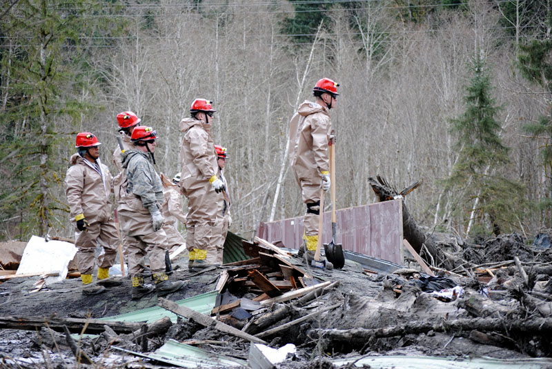
Washington Governor Jay Inslee has acknowledged the Oso landslide could be the deadliest natural disaster in state history.
So far 25 people have been confirmed killed and as many as 90 remain missing. If the ultimate death toll reaches 100 that would eclipse even the 1910 Stevens Pass avalanche that hit two trains.
“We do know this could end up being the largest mass loss of Washingtonians, but whether it is or is not it does not change on how we are approaching this,” said the governor after a bill signing ceremony at the Capitol in Olympia.
Inslee says that approach is to mount a full scale rescue effort. He adds that any one loss is a tragedy.
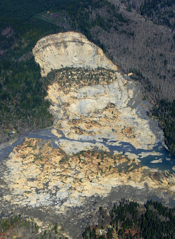
Seattle Times photo. State allowed logging on plateau above slope This aerial photo, taken after Saturday’s landslide, shows part of the plateau that has been logged over the decades. Right above where the hill fell away is a 7½-acre patch, shaped like a triangle, that was clear-cut about nine years ago.
In recent decades the state allowed logging — with restrictions — on the plateau above the Snohomish County hillside that collapsed in last weekend’s deadly mudslide.
The plateau above the soggy hillside that gave way Saturday has been logged for almost a century, with hundreds of acres of softwoods cut and hauled away, according to state records.
But in recent decades, as the slope has become more unstable, scientists have increasingly challenged the timber harvests, with some even warning of possible calamity.
The state has continued to allow logging on the plateau, although it has imposed restrictions at least twice since the 1980s. The remnant of one clear-cut operation is visible in aerial photographs of Saturday’s monstrous mudslide. A triangle — 7½ acres, the shape of a pie slice — can be seen atop the destruction, its tip just cutting into where the hill collapsed.
Multiple factors can contribute to a slide.
With the hill that caved in over the weekend, geologists have pointed to the Stillaguamish River’s erosion of the hill’s base, or toe.
But logging can also play a role in instigating or intensifying a slide, by increasing the amount of water seeping into an unstable zone, according to an analysis of the watershed submitted to the state Department of Natural Resources (DNR).
In May 1988, when a private landowner, Summit Timber, received approval to begin logging above the slope, scientists raised alarms about the removal of trees that intercept or absorb so much water, according to documents obtained by The Seattle Times.
Paul Kennard, a geologist for the Tulalip Tribes, warned regulators that harvesting holds “the potential for a massive and catastrophic failure of the entire hillslope.”
Others echoed his concerns. Noel Wolff, a hydrologist who worked for the state, wrote that “Timber harvesting could possibly cause what is likely an inevitable event to occur sooner.” And Pat Stevenson, an environmental biologist for the Stillaguamish Tribe, cited “the potential for massive failure,” similar to a slide that occurred in 1967.
The agency that issued the permit — the DNR — responded to the concerns by assembling a team of geologists and hydrologists to study the harvest’s potential impact on landslides.
Lee Benda, a geologist with the University of Washington, wrote a report that said harvesting can increase soil water “on the order of 20 to 35 percent” — with that impact lasting 16 to 27 years, until new trees matured. Benda looked at past slides on the hill and found they occurred within five to 10 years of harvests.
In August 1988, the DNR issued a stop-work order, putting Summit Timber’s logging operation on temporary hold.
“1988 was maybe the first time that we were getting serious as to what you should or should not do in terms of logging and road construction around those things,” said Matt Brunengo, at that time a DNR geologist.
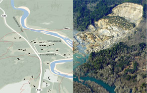
GRAPHIC BY THE SEATTLE TIMES; PHOTO BY TED S. WARREN / AP Use an interactive tool to look at the effects of the mudslide.
A week after the stop-work order, a Summit representative wrote DNR, saying $750,000 to $1 million worth of timber was at stake. He listed alternative steps that could be taken to lessen the risks of a slide — for example, having the state relocate the channel of the Stillaguamish River that was cutting into the hill’s base.
“I can only conclude that the real issue here is not slides and water quality, but timber cutting,” he wrote.
Although records indicate that at least 300 acres were harvested on the plateau in the late 1980s, the state moved to prevent Summit Timber from clear-cutting 48 acres considered most likely to discharge water down the slope.
Mapping out the areas most likely to feed water into unstable terrain is “fraught with uncertainty,” wrote one geologist who studied this landslide zone in the 1990s.
Summit Timber was a family-logging business led by Gary Jones, who grew up in nearby Darrington. Jones believed the acreage atop the hill was second-growth forest, initially logged in the 1920s or 1930s. He said the company eventually backed away from its request to log the 48 acres, given the hill’s history.
“It was a little bit risky,” Jones told The Seattle Times. “We decided not to do it.”
Jones said he was always cautious when working around the river, especially considering he was an avid fly fisherman fond of the Stillaguamish.
Kennard, who now works as a geomorphologist at the National Park Service, said the 1988 application was contentious because the state rarely objected to proposed harvests. Getting the DNR to limit the cut’s scope was no small task, he said.
“That was considered kind of a big victory,” Kennard said.
Concerns about landslides surfaced again in 2004, when property owner Grandy Lake applied for a permit to clear a 15-acre tract near the plateau’s edge.
The state rejected the application, saying some of the proposed logging fell within a sensitive area that could feed water into the slope. Working in that zone would require years of intensive monitoring of precipitation and groundwater.
Grandy Lake revised its application, halving its proposed harvest to avoid the sensitive zone. The final plan — a clear-cut shaped like a right triangle — had an eastern border that abutted the area.
The state approved Grandy Lake’s application while attaching conditions, including: “All yarding and log-hauling activities will cease at the onset of heavy or steady rain and will not resume until the rain has subsided for at least 24 hours.”
Harvesting in that area was finished by August 2005.
Officials with Grandy Lake did not return calls seeking comment Tuesday.
In January 2006, a large slide hit, with so much mud crashing into the Stillaguamish that the river was diverted. Where the hill fell away was maybe 600 feet southwest of the clear-cut area.
Saturday’s slide took more of the hill, reaching right up to that triangle.
Grandy Lake has done selective logging on the plateau in more recent years. Following the approval of a 2009 permit that also included an area abutting the sensitive zone, the company reported to the state that it removed 20 percent of the area’s trees. It returned in 2011 and got approval to take 15 percent more.
Staff reporter Justin Mayo contributed to this report. Mike Baker: mbaker@seattletimes.com or 206-464-2729; Ken Armstrong: karmstrong@seattletimes.com or 206-464-3730
ARLINGTON – A company that makes cups from recycled soda and water bottles is undergoing a $10 million factory expansion here.
MicroGreen will be able to produce 2 million InCycle cups per day after the expansion, up from the current 400,000.
“Our investors expect big things from us – it’s go-time,” said Tom Malone, CEO of MicroGreen, in a statement. “Production is running 24/7 on our existing lines, while we’re also managing the construction site and training new employees.”
Investors include the Stillaguamish Tribe and the Confederated Tribes of Grand Ronde in Oregon.
“We are pleased that our investment in this young company has resulted in creating more than 100 jobs in our local community,” said Shawn Yanity, chairman of the Stillaguamish Tribe, in the press release.
In December, the Confederated Tribes of Grand Ronde funded an equipment loan to MicroGreen and followed that with $5 million in January. This allowed MicroGreen to proceed with expansion.
The company is changing the industry, said Titu Asghar, director of economic development for the Grand Ronde, in the statement.
“We are looking ahead several generations to create an economically sustainable future, supporting clean technology that helps correct wasteful practices with environmentally sound products that are simply better in performance,” he said.
The company, at the Jensen Business Park near Highway 9, uses technology developed at the University of Washington to make the InCycle cups. The idea is to reduce the waste in landfills by using plastic bottles to create cups that can be recycled over and over.
MicroGreen has contracts with several airlines to provide cups for hot beverage service in flight. It’s also looking at using the same technology to expand to other markets, ranging from building construction and electronics to transportation.
SACRAMENTO, Calif. — California began hauling 30 million young chinook salmon hundreds of miles toward the Pacific Ocean in tanker trucks to save the fishing industry after a record drought left rivers too low for migration.
Three climate-controlled trucks, each bearing 130,000 silvery three-inch smolts, left a federal hatchery 180 miles north of San Francisco on Tuesday for a sloshy, three-hour drive to San Pablo Bay, where they are held in netted pens to acclimate before release. Officials had said they might need as many as four vehicles.
Visitors walk over Salmon Falls Bridge, normally submerged, at Folsom Lake in California last month. California began hauling 30 million young chinook salmon hundreds of miles toward the Pacific Ocean in tanker trucks to save the fishing industry after a record drought left rivers too low for migration. KEN JAMES — BLOOMBERG NEWS
“Water conditions, because of the drought, are going to be horrible for the fish,” said Harry Morse of the state Fish and Wildlife Department. “Depending on how far those fish have to go, the longer they must travel through the system, the higher the losses.”
The fish taxi is the latest in a series of emergency steps that state and federal authorities are rushing into place as reservoirs ebb one-third below normal and farmers idle thousands of acres. Gov. Jerry Brown has called for a voluntary 20 percent cut in water use and many areas have declared mandatory restrictions. More than 800 wildfires have broken out since Jan. 1, three times more than usual, according to state records, and smog in Los Angeles is worse without winter rains to clear the air.
California’s 38 million people endured the driest year on record last year. The most-populous state has only about a quarter of the average amount of water in mountain snow that melts in the spring to fill lakes and rivers.
The hatchery fish that typically migrate through the Sacramento River Delta to the sea are key to the state’s $1.5 billion commercial and recreational fishing industry, according to the Nature Conservancy. Fish released now will be part of the population that can be harvested in a few years.
The Pacific Fishery Management Council, which helps set fishing seasons, predicted earlier this month that more than 630,000 fall-run Chinook salmon from the delta are in the Pacific Ocean now. That’s less than last year but more than enough for a normal commercial fishing season, the council said.
The lack of rainfall means that the Sacramento River will prove too shallow and too warm for the tiny fish to survive the 200 to 300 miles of river and tributaries some must navigate to reach the Pacific.
Convoys of four to seven trucks daily will make the trip from the federal hatchery for 22 days during the next two and a half months. In all, 12 million juvenile fish will be taxied from there, along with 18 million raised in four state-owned hatcheries in June. When released from the pens, the tiny fish will migrate to the ocean and mature. They return to the rivers as an adult to spawn.
“Our 2016 fishing season may be riding on the survival of the fish in these trucks,” said Roger Thomas, chairman of the Golden Gate Salmon Association, an advocacy group based in Petaluma. “We know that fish trucked around dangers lurking in the rivers and delta survive at much higher rates than those released at the hatcheries.”
While the state usually trucks some of its hatchery fish to the ocean, this year’s haul will be about three times the usual. It costs California taxpayers $1,500 a week to rent the tanker trucks, and the state expects to spend $150,000 on trucking, including fuel costs, Morse said.
The U.S. Interior Department’s Bureau of Reclamation said last month that it won’t be able to deliver any of the more than 2.4 million acre-feet of water requested by farmers in California’s Central Valley, the state’s most productive agricultural region. An acre-foot is the volume needed to cover an acre of land one foot deep with water.
The Bureau of Reclamation supplies water to 1 million people and a third of the irrigated farmland in California through a 500-mile network of canals and tunnels.
About two-thirds of Californians get at least part of their water from northern mountain rains and snow through a network of state-managed reservoirs and aqueducts known as the State Water Project, which also has said it won’t be able to deliver any of the water requested.
The California Farm Water Coalition said March 17 that farmers probably will fallow as much as 800,000 acres of land because of the lack of water at a cost of $7.5 billion.
Air pollution has become the world’s largest environmental risk, killing an estimated 7 million people in 2012, the World Health Organization says.
That means about 1 out of every 8 deaths in the world each year is due to air pollution. And half of those deaths are caused by household stoves, according to the WHO published Tuesday.
The fumes from stoves that burn coal, wood, dung and leftover crop residues as primary cooking fuels contribute to heart disease, stroke, lung cancer and respiratory infections.
“What people have had available to them are primarily wood, dung and crop residues,” says , an environmental health researcher specializing in air pollution at Harvard University who wasn’t involved in the study. “These three fuels are the most polluting fuels on earth per unit of energy extracted.
“They don’t have a lot of energy, so you have to burn a lot of fuel, and that causes a lot of pollution in the process,” Powers told Shots.
People in low- and middle-income countries in Southeast Asia and the Western Pacific are most affected, with 3.3 million deaths caused by indoor air pollution annually.
But it’s not an easy problem to fix, despite new technologies like solar, gas and electric stoves that are more efficient and healthier than the biomass stoves many are using today.
“No matter how much you improve biomass stoves … you can have some health benefits but you can’t meet health targets,” she tells Shots.
The challenges, she says, lie in distributing less-polluting stoves to people in rural areas, and getting people to want them. Many of these people sit around the stove to keep warm or use the stove to heat their beds, so more efficient stoves may not be accepted if it forces them to change those habits.
“Even if they are given the stove for free, they end up not using it,” Powers says.
The bigger issue at hand is to get cleaner fuels to people, she adds, which will address not only the health hazards but also the environmental problems.
But because of population growth and increasing cost, the shift to cleaner and more efficient use of energy hasn’t made much progress. In fact, the shift has slowed and even reversed, to the International Energy Agency.
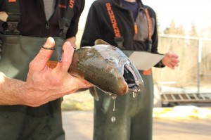
The Puyallup Tribe of Indians is building a library of genetic material from coho salmon to better understand the different populations throughout the Puyallup River watershed.
“The data behind how all these fish are related can give us a pretty clear picture of how many populations are actually here,” said Russ Ladley, resource protection manager for the tribe. “Are populations that have different run timings independent of each other, or do they interbreed?”
A winter coho is sampled for genetic material on the White River, a tributary of the Puyallup.
Winter run coho migrate through the Puyallup as late as February or even March while the earliest run fish are often seen as soon as July. “There isn’t much time when coho aren’t moving into the freshwater to spawn,” Ladley said.
“I would like to collect an adequate sample so we have a background from which to compare,” Ladley said. “I want to know, for example, if the late time coho we see in the White River are different from early coho we see there.”
“Thirty years ago the state Department of Fish and Wildlife sprinkle planted coho fry throughout the watershed, so I would like to find out if the fish are all the same or are still diverse,” he said.
Much of the Puyallup coho’s historic habitat has been degraded in the past century and is still disappearing, making an analysis of interrelationships vital. Coho salmon spend an extra year in freshwater as juveniles compared to other salmon species, making them more vulnerable to declines in freshwater habitat.
For example, low summer flows have been dropping throughout the watershed for decades. “Coho are their most vulnerable when we get to summer low flows,” Ladley said. “Despite a prohibition of new water withdrawals, we’ve seen a continual decline in summer flows because of unregulated wells being allowed to spread across the watershed.”
Low flows reduce the amount of habitat available for coho rearing and can cut fish off completely from valuable habitat. “When it comes down to it, fish need water to survive,” Ladley said.
“Currently, we see a fairly broad range of return timing and coho utilizing habitat from near sea level to 3,000 feet of elevation in Mount Rainier National Park,” Ladley said. “It will be interesting to learn if this is one homogenous stock or whether clear genetic differences exist.”
“This genetic data will give us a clearer picture of exactly how diverse they are, and hopefully give us information we can use to better manage the stock,” he said.
More information on the decline in salmon habitat in the Puyallup River watershed can be found at: http://go.nwifc.org/puyallup and for all of western Washington, here: http://nwifc.org/publications/sow/
(END)
For more information, contact: Russ Ladley, resource protection manager, Puyallup Tribe of Indians, (253) 845-9225. Emmett O’Connell, South Sound Information Officer, NWIFC, (360) 528-4304, eoconnell@nwifc.org
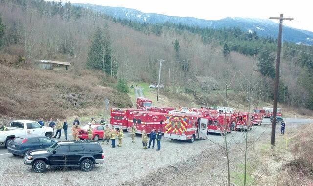
Emergency response on-scene Information Center. Photo: Washington State Patrol.
BY MYNORTHWEST.COM on March 23, 2014 @ 11:10 am (Updated: 8:45 am – 3/24/14 )
Snohomish County’s hotline about reunification, evacuations, and shelters is 425-388-5088.
Residents impacted by the mudslide near Oso are urged to register on the Red Cross website safeandwell.org to list themselves as “safe and well” or to search for other people who are already registered.
You can donate to the Red Cross, any amount is helpful. Call 1-800-RedCross or donate online. You can also text the words RedCross to 90999 and $10 will be charged to your cell phone bill.
Snohomish County says a group of volunteers is helping people affected by the slide move their livestock and pets. The volunteers are located throughout Camano Island, Stanwood, Everett, Arlington and other cities.
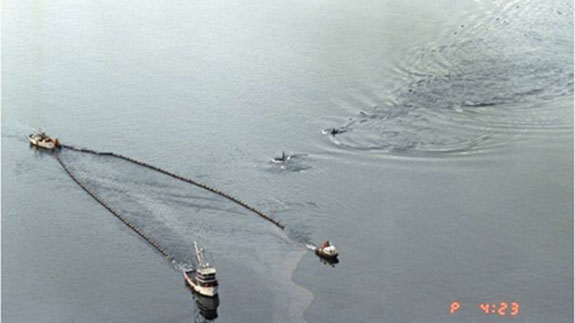
Killer whales swimming in Prince William Sound alongside boats skimming oil from the Exxon Valdez oil spill. Scientists report that orca populations there have not recovered and oil is still being found. | credit: (State of Alaska, Dan Lawn)
25 years ago today the Exxon Valdez, an oil tanker bound for Long Beach, Calif., ran aground in Prince William Sound.
11 million gallons of oil spilled out, polluting 1,300 miles of Alaska’s coastline.
At the time it was the largest oil spill in U.S. history.
Gary Shigenaka and Alan Mearns responded to the Exxon Valdez, and they’ve been studying oil spills ever since. They’re scientists with the National Oceanic and Atmospheric Administration in Seattle.
They told EarthFix’s Ashley Ahearn about their experience responding to the Exxon Valdez all those years ago.
Alan Mearns: Some places we’d go ashore and you’d see starfish that looked like they were sick, they were just kind of drifting around in the surf. And you could smell the oil too, in the places where there was plenty of it. It smelled like benzene, like you’re pumping gas at the gas station and you sniff that little bit of benzene as you pull the hose out of your car.
EarthFix: Gary, how were orcas impacted by the spill?
Gary Shigenaka: Two groups that frequent Prince William Sound crashed immediately after the spill. So since the time of the oil spill those populations have continued to be monitored and we can follow the trends and for the AB pod — the resident pod – there’s been a slow recovery. For the AT1 group, which is the transient pod, it’s been declining ever since the spill and the orca specialist for Prince William Sound, Dr. Craig Matkin, has predicted that that particular group is going to go extinct. It continues to decline with time. So it’s an unfortunate longterm legacy from the spill.
EarthFix: Some people thought the orcas would swim away, would avoid the oil spill itself, but that wasn’t actually the case, was it?
Shigenaka: What we all thought was that orcas are so smart. They will simply avoid the oiled waters. But we’ve got very good photographic evidence that shows that indeed they did not.
One photograph, an aerial photograph, shows orcas cutting through a slick and you can see where they’ve come to the surface right through the oil. There’s another shot of a pod of orcas right at the stern of the Exxon Valdez, right at the tanker.
EarthFix: What creatures were the most impacted or most harmed by the Exxon Valdez spill?
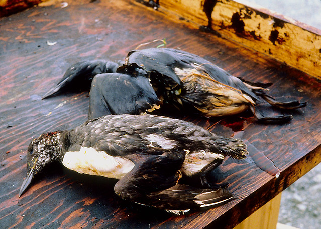
Mearns: Oh, birds. We’re talking about 200 to 300,000 I think, Gary.
Shigenaka: Yeah.
Mearns: Seabirds, mainly seabirds and some shorebirds. And of course that was the big thing you’d see in the news almost every day: pictures of an oiled bird, somebody picking it up, taking it to a wildlife rehabilitation station where they’d clean them and then hold them until they could be released.
Birds killed as a result of oil from the Exxon Valdez spill. Credit: Exxon Valdez Oil Spill Trustee Council.
EarthFix: SO for people who weren’t alive, weren’t reading the paper when the Exxon Valdez spill happened, what were those animals going through? What happens to a bird when it interacts with an oil slick?
Mearns: Well, first of all, even though it’s in the spring and summer it’s still cold up there. If it’s not killed by being smothered by gobs and gobs of oil, if it’s a little bit of oil, it will succumb eventually to things like pneumonia-type diseases and things like that, so it suddenly causes birds that had good insulation not to have insulation and start suffering the effects of cold conditions.
Shigenaka: And the same holds true for another of the iconic wildlife species in Prince William Sound: the sea otters. They insulate themselves with that nice thick fur pelt and they are affected in the same way by oil disrupting their ability to insulate themselves during a spill.
EarthFix: 25 years later, how is Prince William Sound? What species have recovered, how does the place look?
Mearns: Well, 14 or 15 species or resource values have recovered. The recovery started a few years after the spill with things like bald eagles. A number of them were killed off but their population rebounded. The most recent recovery was just announced was of the sea otters that we were just talking about. So between 1991-92 when we started seeing reports of recovery of a few bird species and now we’ve had about 14 or 15 species recover but there’s still some others that haven’t yet.
EarthFix: Which ones are you most concerned about, Alan, or scientists are following most closely with concern?
Mearns: The orcas are really the ones we’re most concerned about now.
EarthFix: Is the oil gone?
Mearns: No. There are still traces of oil in the shorelines. When you go out at low tide and go into some of these back bay areas with gravel and sand overlying bedrock and dig down maybe a foot sometimes you’ll hit spots with oil that is still actually fairly fresh. We’ve encountered that at a few sites that we’ve monitored over the past 25 years.
Shigenaka: That’s been one of the 25-year surprises for us is that there are pockets of relatively fresh oil remaining both in Prince William Sound and along the coast of the Alaska Peninsula and that’s something that I don’t think any of us expected 25 years later.
EarthFix: What did this spill mean for your careers? You guys were both young bucks when this happened. And now, 25 years later, when you look back, what did it mean, the Exxon Valdez?
Shigenaka: I think overall, just the notion that we have a responsibility, both as responders and as scientists to try to communicate what we do and what we know in a way that’s understandable to the people who are affected.
EarthFix: There is more oil moving through this region now – more oil coming from the tar sands of Alberta and coming from the Bakken oil fields of North Dakota to refineries here in Washington state. If I talk to you guys 25 years from now, what do you hope we’re talking about?
Mearns: One thing that I worry about and I think Gary has some other things that he worries about is a lot of this new oil is going to be going through the Aleutian Islands, the great circle route, more and more tankers leaving here or in Canada and heading across. And in the Aleutian Islands, we thought Prince William Sound was remote, well the Aleutian Islands are even more remote. Getting equipment there, getting staff, we’ve had a few experiences with spills. I guess I’m concerned that there will be more spills in that region from this increased traffic out there.
EarthFix: Or elsewhere.
Mearns: Yeah.
Shigenaka: 25 years from now I’m hoping that we have a much better handle on how these novel new oils like the tar sands oil and the Bakken crude oil from North Dakota, how they behave in the environment and what their potential impacts are to exposed organisms because frankly right now we don’t really know how the stuff behaves, both types of oil, once it gets loose in the environment and we’re only beginning to understand what potential impacts there might be for the exposed communities.
Gary Shigenaka and Alan Mearns are scientists with the National Oceanic and Atmospheric Administration in Seattle. They responded to the Exxon Valdez spill 25 years ago.
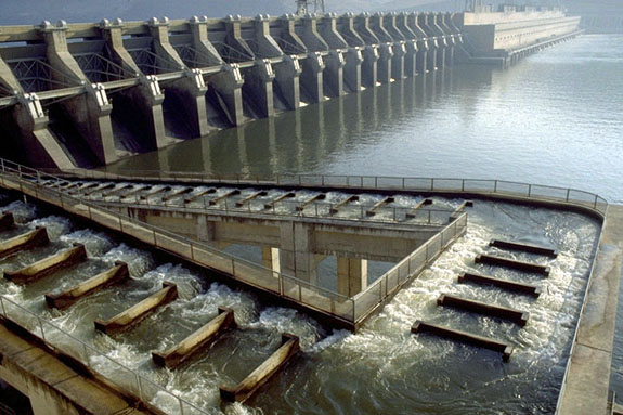
File photo of the fish ladder at John Day Dam on the Columbia River. The fish ladders at the Wanapum and the Rock Island dams are dry. U.S. Army Corps of Engineers
The ongoing issue with the cracked Wanapum Dam in central Washington is now creating a problem for migrating salmon.
The drawdown of water between the Wanapum and the Rock Island dams to relieve pressure on the crack means the water levels are down about 25 feet at the base of both dams.
That leaves fish ladders high and dry.
Now, government fish scientists and engineers are trying to figure out just how to get adult salmon by both hulking concrete structures. At Wanapum, engineers plan to pump water into the fish ladder and create a sort of waterslide for salmon.
Russell Langshaw, a fisheries scientist with Grant County utility district that owns and operates Wanapum, says record numbers of fish are headed that way, so they have to get it figured out by mid-April.
“We have a lot of fish coming back this year, and we agree it’s an absolute necessity that we have safe and effective passage at both Wanapum and Rock Island dams.”
Langshaw says the smaller, juvenile fish are expected to be fine. They’re going downstream, and can move through the spillways and turbines.
Langshaw also says juvenile bypass systems are still operational at the Wanapum and the downstream Priest Rapids dam to help the small fish get downriver.
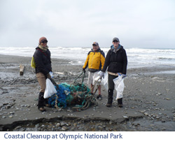
Join NPCA on April 19, 2014 as we partner with other environmental groups to remove debris from Washington beaches. Household plastics, garbage and other manmade debris are polluting our ocean, killing our marine wildlife, and spoiling our beaches and collectively we can do something about it!
This is your opportunity to be a part of the largest coastal cleanup event of the year. Last year a combined 1,000 volunteers removed over 15 tons of oceanic garbage!
We will meet at the Kalaloch Campground Saturday morning and carpool to South Beach for coastal debris removal. Olympic National Park is providing free camping at Kalaloch Campground both Friday and Saturday evenings. The event organizers, CoastSavers, will host a barbeque cookout at the campground Saturday afternoon. We encourage everyone to stay and explore the breathtaking coastlines and rainforests found in this area.
Event Details WHAT: Washington Coastal Clean-Up 2013 hosted by CoastSavers. WHEN: The clean-up is Saturday, April 19 from 9 a.m. to 3 p.m. FREE camping will be available on Friday, April 18 and Saturday, April 19! WHERE: Kalaloch Beach, Olympic National Park. Meet at the Kalaloch Campground in the main parking lot. WHO: Anyone interested–-families welcome! RSVP: Please RSVP to Shannon Brundle, sbrundle@npca.org or 206.903.1444 ext. 704, by Monday, April 14.
OTHER INFO: Remember to bring your work gloves and camping gear if you plan to camp overnight. Food is provided on Saturday at the cookout; please bring your own food and water for the rest of your stay. Also, the free camping is limited and available on a first come, first served basis– plan ahead to make sure you have a site.