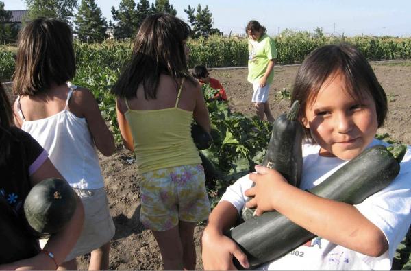
Guided by traditional and spiritual principles, the Cheyenne River Youth Project® has incorporated the traditional Lakota values of generosity, spirituality, wisdom, respect, courage, honesty and patience into the development of its 2-acre, naturally grown, pesticide-free Winyan Toka Win (“Leading Lady” in the Lakota language) garden.
For our ancestors, community gardening was the ONLY form of gardening, but as the landscape of our territories have been whittled away, so has our sense of communal responsibility and communal effort to feed ourselves.
Bringing gardening back to our communities has a number of obvious and not-so-obvious benefits: first, it is a great way to give ourselves dignified access to culturally appropriate foods and it’s a wonderful way to pool resources and strengthen community bonds. That much should be obvious. But did you know that community gardening might also reduce crime rates? One community garden in Philadelphia transformed their neighborhood by revamping and cleaning up an empty lot to house a beautiful community garden. Their efforts had a ripple effect and soon everyone was looking after their property—and their neighbors’—with more care.
And that’s not all: Community gardening gives elders in the community a voice and a chance to share their knowledge while teaching our youth the importance of sustainability and being sovereign—inter-generational exposure of cultural traditions is vital to our communities! Community gardens may also help your community grow traditional foods in a traditional way—something we don’t get from the supermarket.
Spending time in a garden or green space can also help reduce seasonal allergies, stress and air pollution. If built to include a composting station it can also reduce the amount of garbage taken to the landfill every week. And if they are involved in the gardening process, kids (of all ages) are more likely to eat their vegetables.
With all of those benefits, what are you waiting for! Here is how you can start your own community garden in five easy steps:
1. Organize a Meeting
Where will the garden be (find a place with at least 6 hours of sunlight and access to water)? How much are dues? How many plots and what size? What should be planted? Who will be involved? Who will benefit? Is there the possibility of funding or sponsorships to help cover the costs?
2. Form Committees
Who will be in charge of securing funding or collecting dues? Who will buy the seeds? Who will construct the plots? Will there be youth activities or a youth garden? Who will organize the planting and harvesting? Or is it all up to the individual plot owners?
3. Make Rules and Post Them
Involve the community in making the garden rules and the community will follow the rules. When are dues? How will the money be used? Will there be regular meetings? Are individuals responsible for the tending and harvesting of their own plots or is the garden an entire community effort from beginning to end? Will tools be provided to share or is everyone responsible for their own needs? Will the garden be organic?
4. Prepare and Develop Site
Clean the site, create a design or arrangement for the plots, build the garden beds, build a tool shed, and build a compost center. You may want to plant ornamental shrubs around the parameter of the garden to help make the garden look beautiful. You may also have to consider deer fencing or other steps to keep animals out of the garden. Don’t forget to plan pathways in-between all of the plots! Pathways that are able to accommodate wheelbarrows are highly suggested.
What considerations for traditional farming and gardening practices do you need to make? Do you want to honor the ancestors in the design of the garden somehow?
5. Stay in Touch
One of the purposes of a community garden is to strengthen the ties that bond a community. Be sure to create a phone tree, email list and/or put up a bulletin board to help members stay in touch when they need to. Also consider planning monthly workshops aimed at teaching the community how to garden, weed, harvest and maintain pest control without the use of harmful pesticides and herbicides. You can also plan seasonal foraging expeditions for traditional foods– and don’t forget to plan a harvest festival!
Darla Antoine is an enrolled member of the Okanagan Indian Band in British Columbia and grew up in Eastern Washington State. For three years, she worked as a newspaper reporter in the Midwest, reporting on issues relevant to the Native and Hispanic communities, and most recently served as a producer for Native America Calling. In 2011, she moved to Costa Rica, where she currently lives with her husband and their infant son. She lives on an organic and sustainable farm in the “cloud forest”—the highlands of Costa Rica, 9,000 feet above sea level. Due to the high elevation, the conditions for farming and gardening are similar to that of the Pacific Northwest—cold and rainy for most of the year with a short growing season. Antoine has an herb garden, green house, a bee hive, cows, a goat, and two trout ponds stocked with hundreds of rainbow trout.
Read more at http://indiancountrytodaymedianetwork.com/2014/04/07/5-easy-steps-how-start-community-garden-154309