The Capital Land Trust and the Squaxin Island Tribe are working to bring back salmon habitat and protect an important shellfish growing area by restoring a former golf course on Oakland Bay. The land trust recently purchased the 74-acre Bayshore Golf Course, which includes the mouth of Johns Creek and over a thousand feet of Oakland Bay shoreline.
The tribe and the land trust will remove a 1,400 foot dike, restoring the Johns Creek estuary and important marine shoreline. “Taking the dike out will provide salmon with additional acres of saltwater marsh to use as they migrate out to the ocean,” said Jeff Dickison, assistant natural resources director for the tribe..
Eventually, the golf course fairways will also be replanted with native vegetation, restoring a streamside forest that helps provide habitat to salmon.
People round dance around burning tires on the highway during demonstration last fall against SWN Resources Canada’s shale gas exploration work. Photo: APTN/File
By Jorge Barrera, April 15, 2014. Source: APTN News
Another round of battles loom between the Mi’kmaq in New Brunswick and a Houston-headquartered energy firm exploring for shale gas deposits in the province.
SWN Resources Canada has submitted two proposals under the province’s environmental impact assessment process to drill exploratory wells in separate parts of New Brunswick. The projects were registered with the provincial environment department on Monday, according to an official.
The company plans to drill one well in Chipman, which is in central New Brunswick, and a second well near Richibucto, which is in an area that saw intense demonstrations against shale gas exploration last autumn.
The Mi’kmaq community of Elsipogtog is only about 17 kilometres west of Richibucto and its War Chief John Levi said SWN should again expect resistance.
“We are just getting ready to go back out there and stop them. It’s going to be rough,” said Levi. “It ain’t no game. This is our livelihood that is at stake. We are not going to allow it. It’s like they are trying to kill us slowly.”
SWN Resources Canada, which is owned by Houston-based Southwestern Energy Company, could not be reached for comment.
The Mi’kmaq, in an alliance with Acadians and residents of Anglophone communities in the region, led months-long protests against SWN Resources Canada. The Mi’kmaq feared the discovery of shale gas would lead to hydraulic fracturing, or fracking.
The company ended its shale gas seismic exploration work this past December amid burning tires and highway clashes between demonstrators and the RCMP.
The RCMP also launched a heavily armed raid of an anti-fracking camp anchored by the Mi’kmaq Warrior Society last Oct. 17. The camp was blocking a compound holding SWN’s exploration vehicles. The raid triggered day-long clashes and the burning of six RCMP vehicles. Police arrested about 40 people that day.
The company has applied to have its exploration wells approved under the province’s phased EIA process which allows some components of proposed projects to unfold amid the environmental review. The environment department is currently putting together a technical committee to review SWN’s proposed wells, according to a provincial official with knowledge of the file.
SWN wants to build two well pads for vertical drilling that will range in depths between 1,000 and 4,000 metres. The company wants to determine the geology of the area by examining rock samples coming out of the holes, according to the provincial official who has read the company’s proposal.
The environmental assessment will also include input from the public.
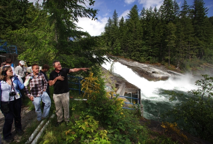
Mark Mulligan / The Herald Kim Moore (in black shirt), assistant general manager for water, generation and corporate services for the Snohomish County PUD, talks with John Baummer (in plaid), a fisheries biologist with the Federal Energy Regulatory Commission, at Sunset Falls last year.
Officials of the Snohomish County Public Utility District now say they can build the project near here without having a structure partially block and divert water — that enough water can be collected in a sharp bend in the river to be sent through a tunnel to a powerhouse downstream.
The previous plan called for pooling water behind a 7-foot, inflatable weir on the river above Sunset Falls before sending it through the 2,200-foot tunnel.
Removing the weir from the Sunset Falls project addresses aesthetic concerns, reduces construction time and cuts $10 million off the project, previously pegged at $133 million, according to the PUD.
“Visually, you really won’t see much,” spokesman Neil Neroutsos said. “Some times of the year, portions of the very top of the intake may be visible.”
One opponent says eliminating the weir wouldn’t help much.
“The bottom line is, if you’re going to produce hydropower in this river, you have to divert enough water form the river’s natural course and channel it to the turbines to make the hydropower. Any significant amount of hydropower you could create would affect salmon habitat,” said Andrea Matzke, who has a cabin near the proposed dam site.
The Tulalip Tribes have expressed concern that reducing water flow in the river could impede outward migration of juvenile salmon. That issue will be studied this spring, PUD officials say.
Nearby residents and environmental groups have opposed the project. They have also cited the fact that rock blasting will be necessary to build the tunnel, contending it could create dust, pollute the river and destabilize the terrain. Studies are expected to address these issues as well.
The new design also includes changes to the tunnel, Neroutsos said, making it narrower in places and reducing the amount of excavation necessary.
The utility has not formally applied with the Federal Energy Regulatory Commission to build the project but has submitted preliminary plans. The PUD is to discuss the new plan with the federal agency over the next couple of weeks, Neroutsos said.
The PUD buys more than 80 percent of its power from the Bonneville Power Administration and is looking to diversify power sources. The project could power up to 22,500 homes at maximum output, according to the PUD. The utility also recently received the go-ahead from FERC for a $26 million pilot project to install tidal power turbines in Admiralty Inlet.
More studies, 17 in all, lie ahead on the Sunset Falls project, and any decision is likely five years away, FERC officials have said.
In May, the PUD is planning to survey ratepayers about the project through its website.
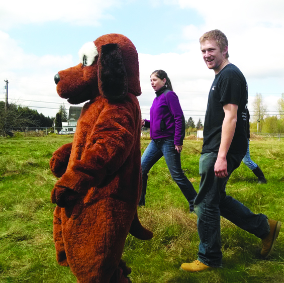
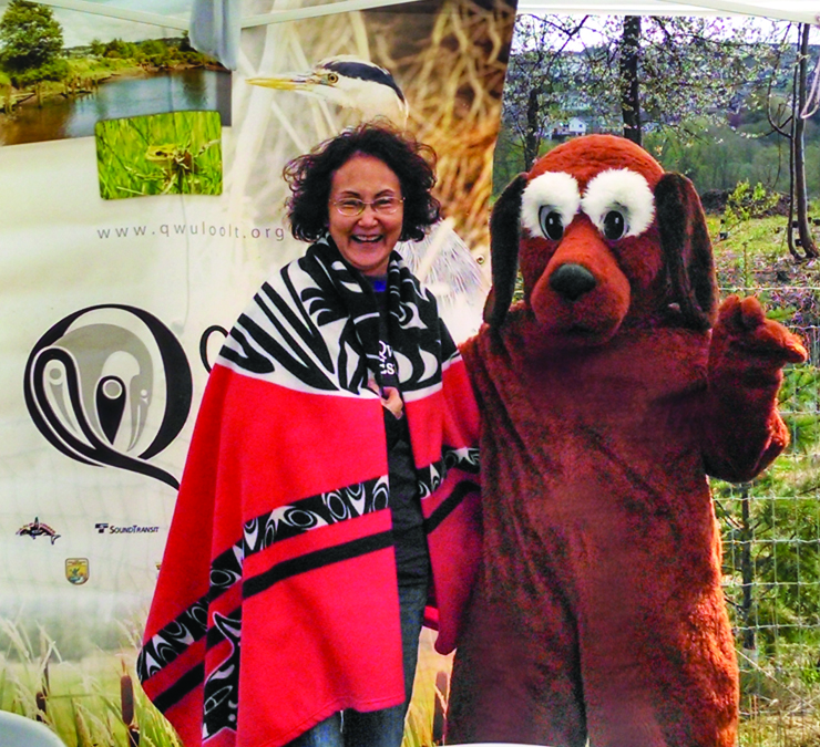
Special guest, Scoopy Doo, showed up to encourage Earth Day attendees to be conscientious and clean up after their pooches. Dog waste is bad for plant, animal, and fish habitat. Photo/Francesca Hillery
By Francesca Hillery, Tulalip Tribes Public Affairs
Two exciting events took place on Saturday, April 12, 2014, to honor Earth Day where tribal staff had an opportunity to help educate the surrounding public about Tulalip’s habitat restoration projects and treaty rights.
The Allen Creek Quilceda Watershed Team (AQWA) hosted their annual Earth Day event at Wilcox Farms in Marysville this year. Several organizations including the Tulalip Tribes, Adopt-a-Stream, Snohomish County Conservation District, Earth Corps, Sound Salmon Solutions, Washington State Department of Ecology, City of Marysville Surface Water Management, and NOAA hosted educational booths to raise awareness of environmental issues affecting the region as well as providing tips and solutions for common problems.
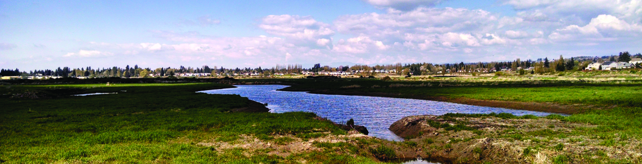
Tulalip hosted a booth on the Qwuloolt Estuary that included information on the history and future of the tribe’s biggest salmon habitat restoration project. Visitors also got to take away a purple t-shirt that displays the Qwuloolt logo.
Tulalip Tribal member Valerie Williams took a break from talking to visitors about the Qwuloolt Estuary and posed with special guest, Scoopy Doo. City of Marysville Surface Water booth sponsored the Scoop the Poop campaign. Photo/Francesca Hillery
Earth Day is hosted at different locations every year so that participants can learn about the various ecosystems around Marysville as well as help plant native plants and trees. Wilcox Farm was donated to the current owner, Bethlehem Lutheran Church, who according to spokesman Jon Natterstad plan to, restore the area of the property that Allen Creek runs through, in order to create “healthy communities for both animals and people .“
An important element to restoration work is planting the plants and trees that are native to the Snohomish watershed. Visitors enjoyed learning about the trees they were planting. This included Western Red Cedar, Sitka Spruce, and Douglas and Grand Firs, which, along with Alder make up Conifer forests.
One of the more poignant messages that came through this year was the importance of picking up after your dog. If dog waste is left in the environment it compromises fresh water sources and salmon habitat. Dogs are our best friends but they need us to help make sure they are good citizens, said one eight year old Earth Day visitor, after meeting Scoopy Doo, who made a surprise appearance, thanks to Sound Salmon Solutions.
The second event of note was hosted by the Tulalip Treaty Rights Office at the Hibulb Cultural Center for a group of 29 student advocates who are part of the Citizen’s Action Training School (CATS) for people engaged in Puget Sound issues. After completing fifty hours of training, where they become familiar with environmental challenges and various recovery projects, the student advocates will then volunteer at a variety of agencies and organizations that are working to restore environmental integrity to priority issues like shellfish, habitat, and stormwater runoff.
The had already completed courses on Climate Change, Nearshore Ecology, Salmon and the Endangered Species Act, Forestry, Shellfish, Marine Mammals, and Water Quality before their trip to Tulalip. “This made for an interested and engaged group,” said Tulalip environmental liaison Daryl Williams. Williams and environmental policy analyst Morgan Ruff gave presentations on the history Treaty Rights as well as current environmental projects the Tulalip Tribes coordinating.
Qwuloolt Estuary Photo/Francesca Hillery
Following the presentation the student advocates were given a tour of the exhibits at Hibulb and were very happy to learn about the culture and history of the Tulalip Tribes. The group then traveled over to the Qwuloolt Estuary site where they had the opportunity to see one of Tulalip’s biggest salmon habitat projects first hand.
At Priest Rapids Dam workers practice transporting salmon in trucks. They’ll have to transport hundreds of fish a day so the salmon can get past the lowered water and several dams. Anna King Northwest News Network
The Columbia River will remain drawn down at least until June because of the cracked Wanapum Dam in southeast Washington.
That means fish can’t reach their traditional ladders, so now hundreds of Chinook salmon are being rounded up and loaded into tanker trucks to hitch a ride around the problem.
A short-term solution
Engineers are working on extensions and “water slides” to get fish ladders at the dam working again. But work to install this new equipment has been difficult with cranes, man baskets and the whipping Columbia River wind.
“You’re up here now and it’s kind of a nice cool breeze. But imagine it with 60 to 70 mile per hour gusts,” says Grant County utility district’s Thomas Stredwick. “And workers and man lifts and trying to haul equipment around — you can see how in pretty short order things can get pretty dicey.”
Workers are installing massive steel structures with wooden slides to help the fish over the dam.
This crew could start to see 12,000 fish collecting per day at the dam in the peak of summer. Already some early migrating fish are forcing a short-term solution that could turn into something longer.
At Priest Rapids Dam, about 20 miles down the Columbia River, Grant County utility district workers are trapping these early migrators so they can be trucked around the dams.
Trucks will fill up with thousands of gallons of river water and about 150 fish per load.
“The most endangered fish we have”
“It’s unthinkable for anyone in the state that we wouldn’t get a salmon run up the river,” says Jeff Korth, a major fish manager for Washington’s Fish and Wildlife.
At the peak of the fish run, Korth’s crew and Grant County utility district employees could be moving about 1,500 fish a day. They’re all hoping that engineers and construction crews can finish fixes on Wanapum and Rock Island dams soon so they won’t have to truck as many fish.
“One thing that’s not fortuitous is that the first run of salmon just happens to be the spring Chinook,” says Korth. “And they are the most endangered fish we have up here. We are going to have to deal with the most critical population, right out of the gate.”
“Never put anything past a fish”
Korth worries that even with the best plans and engineering, working with salmon is still unpredictable.
“That falls under the category that I call never put anything past a fish. If you’re absolutely sure they won’t do something, they’ll end up doing it.”
And if the modified ladder systems don’t work by the time the larger summer run arrives, Korth says, “We’d have to make some very hard decisions. But we’re pretty optimistic we’re not going to get there.”
He adds, “The logistics of hauling something like a half million fish would be pretty difficult.”
Korth says inept ladders would probably mean deciding which runs of salmon to save. Korth says a lot of engineering, policy and sweat has gone into getting salmon past the cracked dam, but we won’t know for at least a few weeks whether all this hard work will pay off.
Plans to put a dam on one of Washington’s most scenic rivers have been called off.
The Snohomish County Public Utilities District says it has a better plan for the area on the Skykomish River near Index. But opponents of the project say it’s still too early to declare a victory.
Snohomish County PUD was planning an inflatable weir for the bend in the river near Sunset Falls, not far from Index. The utility said it had a design that would rise and fall with the river, making it safe for endangered fish runs and minimally disruptive to the scenic value of the area.
“We no longer need a dam, weir or in-river structure,” said assistant general manager Kim Moore.
A Switch To ‘Better Designs’
Moore says extensive studies of the area led the utility to see they could forego the dam, but still put turbines and a tunnel in at the bend in the river near Sunset Falls. And he says it would still produce enough power for about 10,000 homes on average, but would save $10 million and a whole season of construction.
“We’ve just come up with better designs that accomplish reduced cost, reduced impacts, reduced construction. We know the area much better now than we did a year ago,” Moore said.
Opponents Concerned About Preserving The Scenic Waterway
Opponents of the project say it’s risky to divert any water from a river that is home to endangered salmon. And the river is one of just a handful designated as state scenic waterways in Washington.
‘There have been only four rivers that have made that cut, and the Skykomish is one of them,” said Andrea Matzke, a local property owner and president of a new group, Wild Washington Rivers.
Matzke says she’ll keep fighting any hydro project at Sunset Falls, whether a dam is involved or not, because it’s an inappropriate place to put an industrial project. Among the mounting concerns is the potential for mudslides in the area.
“This is an unstable area. Why would they be risking people, even their workers, by bringing in heavy equipment and blasting?” Matzke said.
Early Days Yet
The PUD says it’s still one of the best potential areas they have for developing new sources of alternative energy.
And it’s early days yet. The new plan must be submitted to federal regulators, and getting it licensed would likely take at least three years.
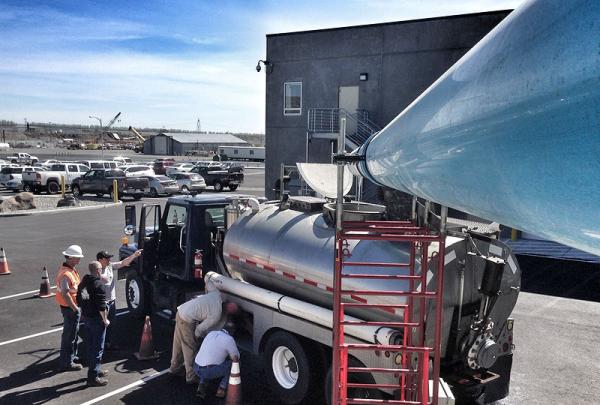
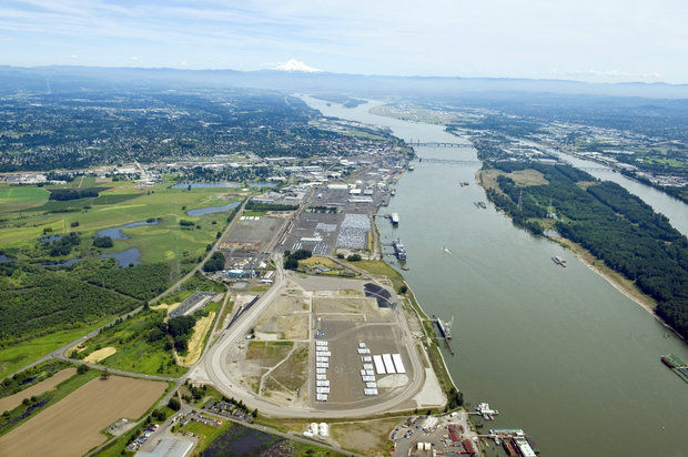
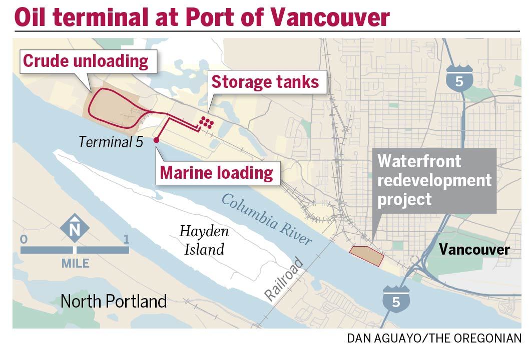
A series of fiery explosions expanded opposition and heightened scrutiny of a Tesoro Corp. and Savage Cos. oil train terminal in Vancouver, Wash., a project that promises to be a bellwether for a growing number of facilities in development along the West Coast.
As we noted in a weekend story, a majority of Vancouver City Council members recently announced they opposed the $110 million terminal, which could process 360,000 barrels of oil daily.
Here are six things you should know about the terminal proposal.
1. It’s big.
It could unload four mile-long trains a day. It could move 131 million barrels of oil annually – seven times more than moved through Washington last year. It would allow Tesoro to move oil to its California refineries for less than the full rail journey would cost.
2. After three major oil train explosions, safety concerns are now driving the debate about the Vancouver terminal.
Building the biggest oil train terminal in the Pacific Northwest was always going to be controversial. But the string of fiery oil train wrecks turned an environmental debate about oil spills and fossil fuels into one about whether the project will put residents’ lives at risk.
Here’s how Jack Burkman, a three-term Vancouver city councilman, put it: “I’m stopped everywhere in town by people I never would’ve expected to be concerned about this. There’s too much lack of understanding. While the likelihood of an accident may be really, really low, the problems we’ve seen have been horrific. That’s what people are having a hard time wrapping their arms around.”
Todd Coleman, the Port of Vancouver’s executive director, put it this way: “(For) people who would’ve otherwise been neutral – fear is powerful.”
3. The string of accidents undercut arguments that something similar couldn’t happen in Vancouver.
When an oil train derailed in Quebec last July, exploding and killing 47 people, the port and Tesoro-Savage said something similar couldn’t happen in Vancouver. They said the BNSF Railway Co., which operates the main line through Vancouver, operated under stricter standards than the rail company in Quebec.
Then a major accident happened on a BNSF rail line in North Dakota in December.
4. The Port of Vancouver has kept secret key details about the terminal.
The port signed a lease in July 2013 with Tesoro-Savage but redacted information in the contract, keeping secret how many trains could go to the site each day.
The Oregonian has asked the port to release an unredacted copy of the lease. A spokeswoman Friday said the agency was re-considering its decision.
5. The Port of Vancouver is trusting that state and federal authorities will address oil train safety.
Uncertainties about tank car safety and crude oil composition led the Port of Portland to reject crude-by-rail terminals until safety gaps are addressed. But in Vancouver, the port is counting on stronger safety standards being in place by the time the project – worth $45 million over 10 years in lease revenue to the port – finishes a state permitting process expected to take a year or longer.
There’s no guarantee safety standards will be ready by the time the terminal is, though. Improving the country’s tank car fleet, for example, could take a decade.
Coleman, the Port of Vancouver official, said his agency may have approached the project differently and gotten safety questions answered up front if it had known more accidents would follow the first major accident last July.
6. The port says a required safety plan will be a backstop if others don’t address safety issues first. But it’s unclear how robust that plan must be.
If federal and state regulators don’t improve oil train safety, Coleman, the port official, said his agency will be able to step in and require key safety measures.
The basis? Two sentences from the port’s 429-page lease with Tesoro-Savage. It says little about what’s required. The lease says:
Something I have always dreamed about has become a reality. It is called an agrihood, a residential neighborhood with a farm at the center—not a golf course, club house or pool, but something really sensible: fresh, organic food!
My dream of long ago was to buy up a large track of land in New England where I live, invite family and friends to invest, and build homes around a central place to grow our own food and be self-sustainable.
In one model neighborhood called Agritopia, a small community based near Phoenix that currently counts 152 families, grows fruit trees, grapes and raises animals. For copy00 per month, members go to the town farm to pick up groceries. The central “square” also functions as a community hub with a coffeehouse and a farm-to-table restaurant, according to The New York Times. Agritopia is also in the process of creating “Generations at Agritopia” for independent and assisted living.
Now many other agrihoods are popping up across the country, such as Serenbe in Chattahoochee Hills, Georgia; Prairie Crossing in Grayslake, Illinois; South Village in South Burlington, Vermont; and Hidden Springs in Boise, Idaho.
“I hear from developers all the time about this,” Ed McMahon, a senior fellow for sustainable development at the Urban Land Institute, a nonprofit real estate research group in Washington, D. C., told the Times. “They’ve figured out that unlike a golf course, which costs millions to build and millions to maintain, they can provide green space that actually earns a profit.” In addition, community residents get a potential tax break for preserving agricultural land.
Agrihoods fulfill a need for people who want open space and fresh air, and lush fields of organic crops, near an urban center. One of the largest suburban farm consultants is Agriburbia in Golden, Colorado, and another near Atlanta, Georgia, called Farmer D Organics. Apparently these similar agencies are inundated with requests for information—and not just from developers but from golf course owners who are anxious to transfer their costly maintenance to a more profitable venture.
Some of these agrihoods have a central farm market, coffeeshop or restaurant, even craft shops, plus views of their food growing right before them. It gives the residents a sense of secure sustainability—healthy food for themselves and their children right in their own back yard, so to speak. The homes in these areas are no more expensive than similar homes nearby. Because one or two crops won’t cut it, these farms must be very diversified so they need a farmer who can understand the community’s needs. The farmer must plant a variety of crops to sell to residents, then have a good enough business sense to sell any excess to local chefs or farm markets. This farm-to-table initiative is growing all over the country.
In older times this way of living would be called tribal. Sharing food grown with all, caring for elders and children first. We Native Americans were not impoverished when we fed ourselves without so much government help. Health and nutrition, food production and economic growth on reservations is now pretty sad. Even here there is new hope in the projects funded by First Nations Development Institute, Native Agriculture & Food Systems Initiative (NAFSI), Native American Food Sovereignty Alliance and other smaller educational grants. I mentioned several of these in my article Grow Food, Not Lawns! (February 22).
This spring will see many elementary schools in indian country involved in planning and planting their own gardens while learning agricultural practices to last a lifetime. The notion of agrihoods is so sensible for all people. Native communities have an edge because they are already a community; they only need to customize the residential side of this farm living to their needs. It will be very interesting to see how agrihoods play out in the coming years throughout the country.
Dale Carson (Abenaki) is the author of three books: New Native American Cooking, Native New England Cooking, and A Dreamcatcher Book. She has written about and demonstrated Native cooking techniques for over 30 years. Dale has four grown children and lives with them and her husband in Madison, Connecticut.
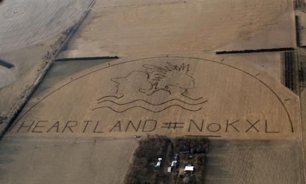
Lou Dematteis/Spectral Q, via Bold Nebraska The crop art image with HEARTLAND #NoKXL protests the proposed Keystone XL pipeline on a corn field outside of Neligh, Nebraska
It’s a message not from an alien species, but from opponents of the Keystone XL pipeline.
Last week a crop-art image the size of 80 football fields was installed along the controversial pipeline’s proposed path in Neligh, Nebraska. The image includes the bust of a man in a cowboy hat and an American Indian in a porcupine roach with two feathers. Under the pair of heads is an illustration of water waves and the text, “HEARTLAND #NoKXL.”
The massive art installation, which was executed by artist John Quigley in partnership with the anti-Keystone XL Pipeline Cowboy and Indian Alliance, is meant to tell President Barack Obama to protect the heartland and reject the pipeline, according to Bold Nebraska, a coalition of groups and individuals opposing the project.
Opponents argue that it will contaminate drinking water and pollute the soil. Conversely, proponents state it will bring jobs to the U.S. The project has been controversial from the start, and now that the decision is down to the wire, the opposition is digging in even further.
“Jobs are not worth the risk of the future of our land,” Tessa McLean, Anishinaabe, a member of the Colorado American Indian Movement and an Idle No More activist, told Indian Country Today Media Network. “Even if the pipeline is safe, even if it never ever spills, it still takes the rights away from land owners. It goes through Indian country, and we don’t want anything going through our country without [our] consent. And Indians will never consent.”
The section of pipeline that still needs approval would cross the border from Canada, where the viscous bitumen originates in the Alberta oil sands, and cut through Montana, South Dakota, Nebraska and Kansas.
Ranchers, farmers and Native Americans who live on the pipeline route plan to descend on Washington, D.C. and camp near the White House beginning on April 22, which is Earth Day, to encourage the president’s support, according to the Cowboy and Indian Alliance website. On April 26, thousands of opponents are expected to join the campers and protest the pipeline.
Several camps are already installed along the pipeline route in Indian country. Descendants of the Ponca Tribe erected a camp in Nebraska in November. A second was established on the Rosebud Sioux reservation on March 29, and the Cheyenne River Sioux Tribe opened one on Saturday April 12.
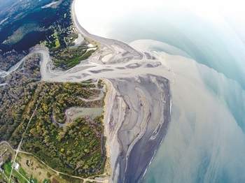
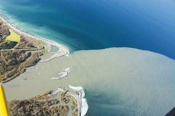
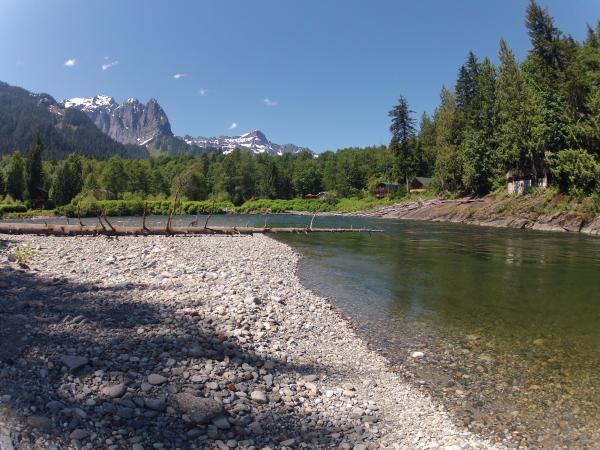
PORT ANGELES — What does roughly 3.3 million cubic yards of sediment look like?
The ever-changing mouth of the Elwha River can offer some clue.
Between November 2012 and September 2013, about 3.3 million cubic yards, or 2.5 million cubic meters, of sediment once locked behind two massive dams along the river has built up at the mouth of the river, according to U.S. Geological Survey data estimates.
The river, which begins in the Olympic Mountains, empties into the Strait of Juan de Fuca west of Port Angeles.
Ocean currents in the Strait and the force of the river itself continuously shape the Elwha’s maw, with the landscape changing on a monthly and weekly basis.
“The river mouth is just changing dramatically all the time,” said Ian Miller, a coastal hazards specialist with Washington Sea Grant.
Millions of cubic yards of sediment have been released from the bottom of the lakes that once bore the names Aldwell and Mills as part of the $325 million Elwha River dam-removal and restoration project begun in September 2011.
The 108-foot, century-old Elwha Dam, which once cradled Lake Aldwell, was completely removed by March 2012, while all but 30 feet remain of once-210-foot Glines Canyon Dam.
The sediment released by dam removal has built up so much at the river’s mouth that areas that were underwater before the dams were removed are now land for hikers.
“There has definitely been some added land, [some] new land created,” Miller said.
Miller is one of a battery of scientists scrutinizing the effects the restoration effort is having on the river’s body, mouth and surrounding environment.
Miller, who has been monitoring changes at the river mouth since dam removal began, said he will be part of a seven-person team the U.S. Geological Survey is organizing at the end of April to gather the most recent estimates of sediment built up there.
Miller said maybe 1 million cubic meters, or 1.3 million cubic yards, of sediment could have been added to the mouth this winter and early spring thanks to a wetter-than-normal February, another notch taken out of Glines Canyon Dam earlier this year and spring snow melt in the Olympic Mountains.
As sediment continues to course down the flowing Elwha, Miller said, the only sure thing about how the mouth looks is that it will change, likely for years to come.
Visit the mouth (watch where you walk!)
Want to see firsthand the dramatic ecosystem changes where the Elwha River spills into the open waters of Freshwater Bay?
From Port Angeles, go west on U.S. Highway 101 to its junction with state Highway 112.
Take Highway 112 west 2.1 miles (crossing the river) to Place Road.
Turn right (north) and follow Place Road 1.9 miles to the “T” intersection.
Turn right (east), go down the hill to the Elwha Dike access point.
Day-use parking is available along the road (note the signs). Follow the Dike Trail a couple hundred yards to the mouth.
This is also a popular surfing spot. Respect private property in the area.
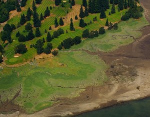
Miller was at the river’s mouth Friday with University of Washington senior Sarra Tekola. Tekola was taking samples of sediment accumulated there to test how much carbon is in the material.
The pair trudged through thick, slate-gray mud on the blustering day, almost losing a boot or two to the sucking muck.
“There are definitely places [that] are softer, and you just have to be sort of careful and test your footing before you put all your weight on it,” Miller said.
Tekola, who’s studying environmental science, said she’s interested in how carbon finds its way into the environment and wants to see how much of the substance a project on the scale of the Elwha River dams removal will release.


 4. The Port of Vancouver has kept secret key details about the terminal.