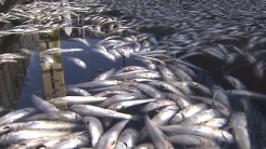
Foul-smelling, silvery blanket covers waters off Marina Del Rey
May 19 2014
Tracy Bloom KTLA.com
Clean up efforts were considered over, but thousands of small dead fish remained in the waters off of Marina Del Rey on Monday morning, two days after they were first discovered.
Scores of dead fish, believed to be mostly anchovies, began washing up in a corner of the marina near Bora Bora Way on Saturday night, creating a foul-smelling, silvery blanket on top of the water.
“It’s horrible. There’s like a million dead anchovies floating around, as well as other fish,” said Lisa Lascody, a resident of the area. “It’s creepy and weird,”
Crews spent Sunday cleaning up, and although carcasses continued to litter the water on Monday, a supervisor with the Los Angeles County Department of Beaches and Harbors said clean up efforts were over.
The supervisor estimated that about 3,000 to 4,000 fish carcasses were removed from the harbor.
The remaining dead fish floating in the water would either get eaten or eventually be pushed out into the ocean, the supervisor added.
It was unclear why exactly the dead fish washed up in the first place, but one marine expert speculates the amount of fish could have sucked the oxygen out of the water, and that could have caused them to die.
“The currents in here… it gets trapped in here, it doesn’t have a good flow. So it’s possible all these anchovies came in here, then all the other fish came in here, and all of that massive load of anchovies…sucked out all of the oxygen in the water. And through that, everything died,” said Eric Martin, the facility director and educational co-director of Roundhouse Aquarium, a marine studies lab in Manhattan Beach that teaches about the ocean and marine life.
The was not the first time numerous dead fish showed up dead in Southern California waters. In March 2011, millions of small fish turned up dead in King Harbor in Redondo Beach, according to the Los Angeles Times.
In that incident, it was believed that the fish used up all the oxygen after swimming into the marine en masse and eventually suffocated, the Times reported.
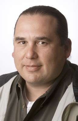
Phil Rigdon, the director of Yakama Natural Resources Program and president of the Intertribal Timber Council
Federal funding cuts pose dire consequence for the ability of tribes to manage their land and reduce wildfire risks, a Yakama Nation leader told a U.S. Senate hearing Wednesday in Washington, D.C.
Phil Rigdon, the director of the Yakamas’ natural resources program and president of the Intertribal Timber Council, told the Senate Committee on Indian Affairs that programs that once kept tribal forests healthy are now “running on fumes.”
“The consequences of chronic underfunding and understaffing are materializing,” Rigdon told the committee. “The situation is now reaching crisis proportions and it’s placing our forests in great peril.”
There are more than 18 million acres of tribal forest lands held in trust by the federal government, but the Bureau of Indian Affairs gets far less funding per acre for forest management and fire risk reduction than national forests.
Funding has fallen 24 percent since 2001, Rigdon said, and that can have dire consequences.
For example, last year when the Mile Marker 28 Fire broke out off U.S. Highway 97 on the Yakama reservation, only one heavy equipment operator and one tanker truck were able to respond immediately because that’s all the current federal budget supports, Rigdon said in an interview before the hearing.
“Back in the early 1990s, when I fought fire, we would have three or four heavy equipment operators,” he said. “Someone was always on duty. That’s the kind of thing that’s really changed.”
The Mile Marker 28 Fire eventually burned 20,000 acres of forest.
Rigdon noted that the dozens of tribes around the country that are represented by the Timber Council are proud of the work they do when resources are available.
“If you go to the Yakama reservation and see our forests, we’ve reduced disease and the risk of catastrophic fire. If we don’t continue to do that type of work — if we put it off to later — we’ll see the types of 100,000- or 200,000-acre fires you see other places,” Rigdon said.
Currently, there are 33 unfilled forestry positions at the BIA for the Yakama Nation, he added. That limits the program’s ability to hit harvest targets, which hurts the tribe economically and affects the health of the forest.
A 2013 report from the Indian Forest Management Assessment Team found that an additional $100 million in annual funding and 800 new employees are needed to maintain strong forestry programs on BIA land nationwide. The current budget is $154 million.
In addition to the concern over future funding, other members of the panel also discussed the different approaches to forest management by tribes and the Forest Service.
“We’ve done a good job maintaining a healthy forest on a shoestring budget, but the Forest Service is not maintaining its adjacent lands,” said Danny Breuninger Sr., the president of the Mescalero Apache Nation in New Mexico.
Committee member Sen. John McCain, R-Ariz., cited a 2011 Arizona fire as an example of how tribal efforts can succeed. In the wake of a 2002 fire, the White Mountain Apache conducted salvage logging and thinning work while the adjacent national forest did not. When fire hit the region again, federal forests were devastated, but the treated tribal forests stopped the fire’s spread.
Jonathan Brooks, forest manager for the White Mountain Apache, told McCain that lawsuits prevent the Forest Service from doing similar work.
“Active management gets environmental activists angry,” Brooks said. “But what’s more hurtful to the resources: logging, thinning and prescribed fire, or devastating fires?”
Rigdon said the Intertribal Timber Council would like to see increased abilities for tribes to work with neighboring national forests on management projects like thinning, which could support tribe-owned sawmills and reduce fire risks.
The Yakama Nation is working with the Forest Service on developing such a collaborative project, as part of a new program known as “anchor forests.” It’s a pilot program currently being used on a few reservations, and the panelists at the hearing supported expanding it to more regions.
Anchor forests are intended to balance the economic and ecological needs of a forest through a collaborative effort involving tribes, the BIA and local, state and federal agencies.
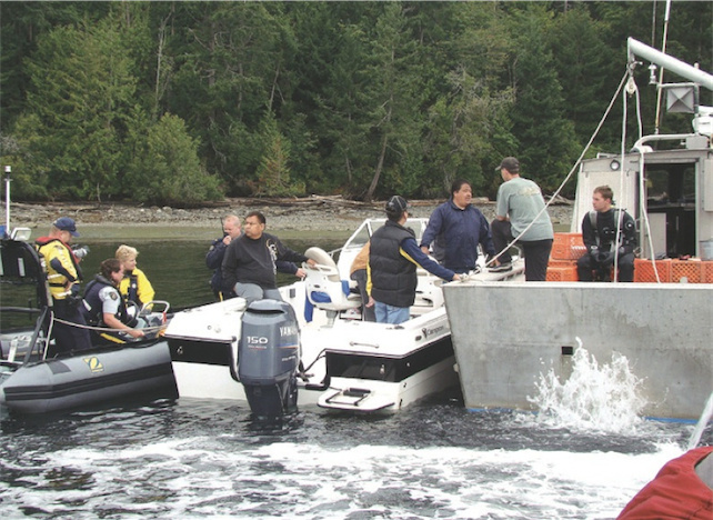
The Stz’uminus (Chemainus) First Nation has enacted a blockade that spans its traditional territory in the Gulf Islands of BC. They say they’ve been let down by a recent Department of Fisheries and Oceans (DFO) policy decision to restrict their ability to culture geoducks, a hugely valuable clam species that is already harvested commercially in the area.
“We’re trying to send a message to DFO,” says Ray Gauthier, CEO of the Coast Salish Development Corporation and the man behind the blockade. “If you’re not going to acknowledge our interests… then we’re going to reclaim the area.”
Nobody from DFO was made available speak with VICE, but the agency sent a statement, saying: “Officials are engaged in ongoing discussions with the Stz’uminus to understand their concerns and interest.”
It’s the “ongoing” part that has enraged the First Nation.
Six years ago they applied for permission to conduct a 100-hectare geoduck aquaculture operation in the waters off their reserve near Nanaimo. The undeniably phallic clams grow up to a metre long, and can sell for $50 a kilo to Asian markets.
Band officials saw the lucrative geoduck harvest as a chance to build the local economy and make the reserve more self-sufficient.
“We don’t have our hand out here,” says Gauthier. “We’re not asking for money.”
But the plan stalled. Then, after two years of frustration, the First Nation blockaded commercial operations in Kulleet Bay in 2010, preventing the divers from getting in the water. “The message was, if we can’t have access to the industry, then neither can you,” Gauthier recalls.
They threatened to blockade the bay again the following year, but the commercial geoduck harvesters steered clear. A few weeks ago, the First Nation was given a one-time opportunity to apply to harvest in five hectares. They say it’s not enough. “This new policy that was supposed to address aboriginal interests simply doesn’t,” says Gauthier.
Now they’re blockading much more than just one fishery in just one bay: they’re planning on blocking access to “all vessels including but not limited to commercial fishing vessels, DFO vessels and any non-native civilians and government officials,” within their traditional territory. That territory spans from Active Pass to Gabriola Island, heavily used areas in the Gulf Islands.
Gauthier says the issue is that the government is shirking its duty to consult with First Nations prior to making decisions regarding resources they have the right to use. “It doesn’t mean you have a meeting and it’s all good, he says. “They’re having trouble with the concept.”
That alleged failure to consult has attracted the interest of “10 or 12” other First Nations. Meaning, depending on the outcome, this protest could grow. No confrontations have occurred yet, but Gauthier says the blockade is in full swing.
FALL CITY, Wash. — Washington state’s five steelhead hatcheries are on high alert after someone broke into a facility overnight and released approximately 25,000 juvenile fish into the Snoqualmie River.
State Fish and Wildlife Hatchery managers are concerned it was an act of defiance against a new agreement that sharply curtails the state’s steelhead hatchery program. The agreement resulted from a lawsuit filed by a fish protection group, Wild Fish Conservancy, which accused the State of violating the Endangered Species Act. State Fish and Wildlife Managers agreed to stop planting winter steelhead hatchery fish in all but one river.
This set off a wave of criticism by some sport anglers who eagerly await the steelhead runs each year.
It also left the state with huge numbers of steelhead that could not be released into tributaries of Puget Sound. Whoever struck the Tokul Creek facility on the Snoqualmie appeared to know the hatchery was planning to truck its large inventory of steelhead to the east side of the state where they would be released into lakes that would not allow them to migrate to the Sound.
State Fish and Wildlife Enforcement officers and King County Sheriffs deputies are investigating the break in. Hatchery workers say whoever did it cut the lock off a tall chain link fence, entered the hatchery grounds and pulled the screens that prevented the steelhead from entering the creek and Snoqualmie River.
Private security officers have been hired to patrol the other hatcheries until police figure out if this is an isolated case or part of an organized resistance to the settlement.
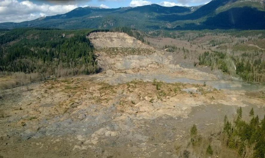
File photo of landslide near Oso, Washington. credit: Washington Governor’s Office File photo of landslide near Oso, Washington. | credit: Washington Governor’s Office
A federal geologist doubts the cause of the deadly landslide near Oso, Washington will ever be fully pinned down.
During testimony in Olympia Monday, U.S. Geological Survey scientist Jonathan Godt said heavy rains in February and March certainly contributed to the slide. Geologists have also ruled out an earthquake as a trigger. But Godt says a big missing piece is groundwater flows, for which there’s no data.
“We didn’t have instruments in the ground at the time the landslide occurred and you can’t put the slide back up on the slope,” Godt said. “So from an observational standpoint, that opportunity is lost.”
Godt spoke to the Washington Forest Practices Board, a panel which is reexamining logging rules around landslide prone areas. A Washington state geologist and a private consulting geologist also presented there Monday. None would speculate if historic clear-cuts had anything to do with the March landslide.
Investigators are asking for more money from FEMA to probe why the Oso landslide traveled so far from its origin.
The death toll from the March 22 slide in Snohomish County stands at 41. Two additional people are still listed as missing.
Native Americans have long had a close relationship with their lands and waters—sacred places and resources that define their lives. The disruptions wrought by a warming climate are forcing abrupt cultural changes on peoples with a long reliance on a once stable ecosystem.
Among the special issues affecting tribes, the 2013 Assessment of Climate Change in the Southwestern United States (SWCA) cited “cultural and religious impacts, impacts to sustainable livelihoods, population emigration, and threats to the feasibility of living conditions.”
The Hoh, Quinault, Quileute and Makah nations inhabit low-lying land along the west coast of Washington State, and face similar threats as rising sea levels and the other impacts of climate disruptions endanger their villages.
”The area is relatively vulnerable,” Patty Glick, senior global warming specialist and author of a 2007 National Wildlife Federation report, ”Sea Level Rise and Coastal Habitats in the Pacific Northwest,” told Indian Country Today Media Network in 2008. Higher wave action, wave force and destructive storm surges will increase in the coming decade, Glick said, and destructive storms such as the hurricanes will become more frequent.
The Hoh road to the beach has washed out, and the ocean has destroyed the homes that once lined their beach. In Quinault, a passing storm tossed gigantic logs onto the school grounds. These events intensified both tribes’ agenda to get higher ground returned from the Olympic National Park beyond their tiny reservation boundaries.
The Makah and the Quinault nations have large reservations, but their seaside villages are at risk, as evidenced by the recent state of emergency at Quinault headquarters in Taholah, which faced an increasingly dangerous situation with sea level rise and intensified storms, which breached a sea wall causing serious damage.
According to Climate Central, which uses data from NOAA and the USGS, there is a greater than one in six chance that sea level rise, plus storm surge, plus tides, will raise sea levels by more than one foot before 2020 along the coastline and in the Puget Sound region, where another eight tribes are situated. The Shoalwater Bay sits nearly out to sea in southwest Washington.
Rising sea levels will affect Washington’s shoreline habitat for vegetation, animals, birds and fish, according to Glick’s report. Marshes, swamps and tidal flats will be significantly affected, and salmon and shellfish habitat are expected to be significantly affected, Glick reported.
Along Alaska’s northwestern coast, melting sea ice has reduced natural coastal protection. Increased coastal erosion is causing some shorelines to retreat at rates averaging tens of feet per year. In Shishmaref and Kivalina, Alaska, severe erosion has caused homes to collapse into the sea, according to the Environmental Protection Agency, forcing these Alaska Native Village populations to relocate in order to protect lives and property.
Moving inland, “Climate change is slowly tipping the balance in favor of more frequent, longer lasting, and more intense droughts,” states the SWCA. The Navajo Nation is experiencing annual average temperatures warmer than the 1904-2011 average, cites a climate report released in March 2014. Latest figures show their drought continuing beyond 2010 studies into July 2013, indicating the drought continues.
Perhaps among the worst of those impacts are the runaway sand dunes it has unleashed, which extend over one-third the 27,000-square-mile reservation. During the 1996-2009 drought period the extent of dune fields increased by some 70%. These dunes are moving at rates of approximately 35 meters per year, covering houses, burying cars and snarling traffic, degrading grazing and agricultural lands, contributing to the loss of rare and endangered native plants, and when they occur contributing to poor air quality, a serious health concern for many of the reservation’s 173,667 residents.
Intertribal organizations around the U.S. are recognizing climate change and variability as a significant factor that can impact tribal resources, livelihoods, and cultures, cites the latest tribal climate report. The National Tribal Air Association notes that “perhaps no other community of people has experienced the adverse impacts of climate change more than the nation’s Indian tribes.”
The struggle will soon come to more tribes. Sea level rise projections do not bode well and may already be a cause of concern for the tribes along Louisiana’s Gulf of Mexico—the United Houma Nation, the Atakapa-Ishak Nation, Pointe-au-Chien Tribe, and the Biloxi-Chitimacha’s Isle de Jean Charles Band, Grand Caillou/Dulac Band and Bayou Lafourche Band. In Florida—the Miccosukee, and some locations of the Seminole Indian Reservations. Ocean residing tribal nations in California include the Agua Caliente Band of Cahuilla, Cahto, Chumash, Hoopa, Karok, Kumeyaay, Luiseño Bands of Indians, Maidu, Miwok, and some bands of the Pomo Nation. Some are more at risk than others.
Democratic Gov. Jay Inslee says Washington will likely adopt a California-style pollution limit on gasoline and other transportation fuels.
Inslee recently ordered a feasibility and cost study of a low-carbon fuel standard.
For months now, Washington Republicans have been predicting that Inslee will use his executive powers to enact a low-carbon fuel standard. Inslee acknowledges he’s looking at ways to do this without legislative approval. Either way he thinks Washington is poised to move forward.
“I think it’s a probability that we will be able to fashion a low-carbon fuel standard that will be effective for the state of Washington, both for carbon pollution and from a cost-containment standpoint,” Inslee said during an appearance on Seattle Channel’s “Civic Cocktail” program. “From what I know today, I think it’s a likelihood we will succeed in fashioning that, but I want reiterate we’re going to have a very sophisticated, thorough evaluation of that before I make that ultimate decision.”
A low-carbon fuel standard is basically a requirement that vehicle fuels be blended with less carbon-intensive alternative fuels. For instance, California’s standard requires a 10 percent reduction in carbon intensity of gas and diesel over 10 years.
Inslee has promised a “deliberative, public process” as he pursues carbon pollution reduction measures in Washington. Legislative Republicans oppose a fuel standard and say it could drive up the cost of gasoline.
An international team led by glaciologists from the University of Colorado Boulder and Trent University in Ontario, Canada has completed the first mapping of virtually all of the world’s glaciers — including their locations and sizes — allowing for calculations of their volumes and ongoing contributions to global sea rise as the world warms.
The team mapped and catalogued some 198,000 glaciers around the world as part of the massive Randolph Glacier Inventory, or RGI, to better understand rising seas over the coming decades as anthropogenic greenhouse gases heat the planet. Led by CU-Boulder Professor Tad Pfeffer and Trent University Professor Graham Cogley, the team included 74 scientists from 18 countries, most working on an unpaid, volunteer basis.
The project was undertaken in large part to provide the best information possible for the recently released Fifth Assessment of the Intergovernmental Panel on Climate Change, or IPCC. While the Greenland and Antarctic ice sheets are both losing mass, it is the smaller glaciers that are contributing the most to rising seas now and that will continue to do so into the next century, said Pfeffer, a lead author on the new IPCC sea rise chapter and fellow at CU-Boulder’s Institute of Arctic and Alpine Research.
“I don’t think anyone could make meaningful progress on projecting glacier changes if the Randolph inventory was not available,” said Pfeffer, the first author on the RGI paper published online today in the Journal of Glaciology. Pfeffer said while funding for mountain glacier research has almost completely dried up in the United States in recent years with the exception of grants from NASA, there has been continuing funding by a number of European groups.
Since the world’s glaciers are expected to shrink drastically in the next century as the temperatures rise, the new RGI — named after one of the group’s meeting places in New Hampshire — is critical, said Pfeffer. In the RGI each individual glacier is represented by an accurate, computerized outline, making forecasts of glacier-climate interactions more precise.
“This means that people can now do research that they simply could not do before,” said Cogley, the corresponding author on the new Journal of Glaciology paper. “It’s now possible to conduct much more robust modeling for what might happen to these glaciers in the future.”
As part of the RGI effort, the team mapped intricate glacier complexes in places like Alaska, Patagonia, central Asia and the Himalayas, as well as the peripheral glaciers surrounding the two great ice sheets in Greenland and Antarctica, said Pfeffer. “In order to model these glaciers, we have to know their individual characteristics, not simply an average or aggregate picture. That was one of the most difficult parts of the project.”
The team used satellite images and maps to outline the area and location of each glacier. The researchers can combine that information with a digital elevation model, then use a technique known as “power law scaling” to determine volumes of various collections of glaciers.
In addition to impacting global sea rise, the melting of the world’s glaciers over the next 100 years will severely affect regional water resources for uses like irrigation and hydropower, said Pfeffer. The melting also has implications for natural hazards like “glacier outburst” floods that may occur as the glaciers shrink, he said.
The total extent of glaciers in the RGI is roughly 280,000 square miles or 727,000 square kilometers — an area slightly larger than Texas or about the size of Germany, Denmark and Poland combined. The team estimated that the corresponding total volume of sea rise collectively held by the glaciers is 14 to 18 inches, or 350 to 470 millimeters.
The new estimates are less than some previous estimates, and in total they are less than 1 percent of the amount of water stored in the Greenland and Antarctic ice sheets, which collectively contain slightly more than 200 feet, or 63 meters, of sea rise.
“A lot of people think that the contribution of glaciers to sea rise is insignificant when compared with the big ice sheets,” said Pfeffer, also a professor in CU-Boulder’s civil, environmental and architectural engineering department. “But in the first several decades of the present century it is going to be this glacier reservoir that will be the primary contributor to sea rise. The real concern for city planners and coastal engineers will be in the coming decades, because 2100 is pretty far off to have to make meaningful decisions.”
Part of the RGI was based on the Global Land Ice Measurements from Space Initiative, or GLIMS, which involved more than 60 institutions from around the world and which contributed the baseline dataset for the RGI. Another important research data tool for the RGI was the European-funded program “Ice2Sea,” which brings together scientific and operational expertise from 24 leading institutions across Europe and beyond.
The GLIMS glacier database and website are maintained by CU-Boulder’s National Snow and Ice Data Center, or NSIDC. The GLIMS research team at NSIDC includes principal investigator Richard Armstrong, technical lead Bruce Raup and remote-sensing specialist Siri Jodha Singh Khalsa.
NSIDC is part of the Cooperative Institute for Research in Environmental Sciences, or CIRES, a joint venture between CU-Boulder and the National Oceanic and Atmospheric Administration.
– See more at: http://www.colorado.edu/news/releases/2014/05/06/international-team-maps-nearly-200000-glaciers-quest-sea-level-rise#sthash.W6vK18yo.dpuf
Indian rights lawyers argue that a Sandpiper spill could endanger their rights to gather wild rice.
By David Shaffer, Star Tribune
In a new battlefront over energy policy, American Indian rights attorneys argued Wednesday before a Minnesota judge that historic treaties give tribes a say in where to build crude oil pipelines across land ceded by the Chippewa in the 19th century.
“Everybody has kind of forgotten what our rights are, and that is why we are here,” Frank Bibeau, an attorney for the Indian nonprofit group Honor the Earth, told an administrative law judge at a hearing in St. Paul.
Honor the Earth says the proposed $2.6 billion Sandpiper crude oil pipeline across northern Minnesota will produce “inevitable oil spills and environmental degradation” on ceded lands. Spills could endanger Rice Lake near McGregor and Sandy Lake in Aitkin County where Indians gather wild rice, the group says.
For the first time in Minnesota, Indian rights attorneys are arguing that the state Public Utilities Commission (PUC) lacks unilateral authority to approve pipelines. They want the state to reject the proposed route of the Sandpiper pipeline from North Dakota, and have offered an alternative path.
Enbridge Energy’s preferred pipeline route goes southeast from Clearbrook, Minn., passing west of Park Rapids and then heading east to Superior, Wis. It avoids Indian reservations, but passes through ceded lands on which Chippewa bands retain the right to fish, hunt and gather rice.
Attorneys for the company contend that the commission has no business deciding the meaning of federal treaties. Even so, much of the two-hour discussion before Judge Eric Lipman focused on 10 treaties signed between 1825 and 1864 by Minnesota Indian tribes.
“It would represent a dramatic departure from the commission’s precedent and would significantly impact not just pipeline projects but all large energy projects sited in northern Minnesota,” said Christine Brusven, an attorney for the Calgary-based pipeline company that’s proposing to build the 610-mile pipeline to carry North Dakota oil.
Headed for the courts?
Lipman, who is overseeing the regulatory review of the pipeline, is expected to rule on the treaty rights question, but the final decision rests with the Public Utilities Commission. The issue ultimately could land in federal court.
Before the hearing, about 45 Honor the Earth supporters, led by the group’s leader Winona LaDuke, demonstrated outside the PUC’s office.
Some Minnesota tribes have successfully asserted off-reservation rights under 19th century treaties. The U.S. Supreme Court in 1999 affirmed that the Mille Lacs Band of Chippewa and seven other Chippewa bands retained hunting, fishing and gathering rights under an 1837 treaty on lands and lakes ceded by the tribes in central Minnesota, including Lake Mille Lacs.
Similar rights have been recognized under other treaties, and state and tribal governments share responsibility for game management in some ceded areas. This year, the Fond du Lac Band of Chippewa is exercising rights under an 1854 treaty to spear walleyes in several lakes in northeastern Minnesota’s Arrowhead region.
Honor the Earth attorneys contend that the 19th century treaties and early 20th century court rulings about wild rice reserves give the Ojibwe a present-day right to help make decisions affecting treaty-related resources.
“We are not saying we have an absolute veto,” Bibeau said in an interview.
Cooperation sought
Prof. Peter Erlinder of William Mitchell College of Law, who also represents Honor the Earth, said various treaties “need to be accommodated by state regulatory activities.” He said the state and tribes need to find a way to cooperate on pipeline siting.
But Enbridge attorney Randy Thompson, who represented Lake Mille Lacs landowners in the 1999 case, said Honor the Earth overstates the reach of the landmark decision.
“It is a nonexclusive right to hunt and fish,” Thompson said. “It gives bands the ability to self-regulate hunting and fishing by band members. It doesn’t give bands co-management authority. It doesn’t give the bands the ability to regulate nonmembers.”
Legal experts say protection of natural resources under 19th century Indian treaties is an emerging area of law.
“We have very little idea where it is going to go,” said James Coleman, an assistant professor of energy law at the University of Calgary and Haskayne School of Business.
In the state of Washington, a tribe with rights to fish for migrating salmon has successfully argued that the state Transportation Department must repair hundreds of culverts that block the passage of fish. Federal judges, most recently in 2013, have ruled that the barrier culverts violate treaty promises. Another federal judge in that state upheld in 1996 the U.S. Army Corps of Engineers’ right to deny a permit for a fish farm because it conflicted with the Lummi Nation’s treaty fishing rights.
Most treaty cases have been decided in federal court. Honor the Earth’s legal battle is unusual because it’s in a state regulatory proceeding. Bibeau said he reserves the right to take the case to tribal or federal court later.
Two precedents
In two previous Minnesota utility cases, tribes tried unsuccessfully to assert tribal authority over proposed pipelines or power lines. In 2011, the Leech Lake Band of Ojibwe objected to a proposed transmission line that skirted tribal lands, but lost in federal court. The Fond du Lac Band of Lake Superior Chippewa objected to another pipeline in 2007. That project, like the transmission line, eventually won approval of the PUC.
Coleman, who grew up in the Twin Cities, said Indian activists face a difficult legal battle in the pipeline case. Unlike the Washington cases, he said, where judges saw actual harm to treaty-protected resources, the Minnesota concerns are about a potential situation, and depending on how bad the disaster was, maybe at some point it could eliminate those treaty rights.
OLYMPIA – Sen. John McCoy, D-Tulalip, has been named to a new Joint Select Task Force on Nuclear Energy.
McCoy, the ranking member on the Senate Energy, Environment & Telecommunications Committee, will be one of eight legislators tasked with studying the viability of increased nuclear power production as a tool in reducing the state’s use of carbon-emitting fossil fuels.
“It’s crucial we take a close look at all potential renewable resources, including nuclear energy,” McCoy said. “At the same time, it’s also important that we gather all the facts and make informed decisions about our state’s clean energy future.”
The task force is expected to hold up to four meetings, including two in Richland. The task force is composed of equal numbers of Republicans and Democrats from the state House and Senate and will report their findings to the Legislature by Dec. 1.