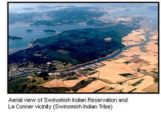
(Seattle—July 23, 2014) The U.S. Environmental Protection Agency announced today it is awarding over $756,000 to the Swinomish Indian Tribal Community to research coastal climate impacts to traditional foods, cultural sites and tribal community health and well-being. The combination of sea level rise, wave impacts, and shoreline development will change coastal ecosystems that support Swinomish first foods and place-based relationships, which in turn impacts community health and well-being.
The funds will be used to: · Develop a model showing projected coastal erosion due to sea-level rise, storm surge, and wave energy through Year 2100 on the shores of the Swinomish Reservation · Map the vulnerability of Swinomish coastal ecosystem habitats of first foods and culturally significant sites · Support the Swinomish Climate Change Initiative · Create educational and outreach tools for Swinomish community members and Coast Salish communities · Assess research results and develop adaptive strategies EPA funds research focused on tribal communities through the Science to Achieve Results program. Because many tribes rely on natural resources, it is essential for tribal-focused research to identify possible environmental health risks and the most efficient methods of avoiding or addressing these risks.
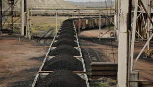
A council of governments in the central Puget Sound region commissioned a study by an independent consultant. It concluded that economic benefits of a proposed coal export terminal would be concentrated in Whatcom County, where it would be built. | credit: Katie Campbell
If it’s built, the coal-exporting Gateway Pacific Terminal will create more than two thousand jobs in Whatcom County during construction and several hundred permanent jobs once it’s operational.
“It’s an economic model that creates very few jobs, certainly very, very few in the region … and has grave consequences for mobility here in Puget Sound,” King County Executive Dow Constantine said in response to the study.
Low income communities in Kent and Seattle will be disproportionately affected by the coal train traffic, according to the study. Residential and commercial properties along coal train routes could decline as much as $282.3 million and $133 million, respectively.
“Communities along the rail lines will face a host of negative impacts, most of those are bad for business, with very little positive economic development from this particular activity and there’s no assurance the costs of upgrades won’t fall to us as well,” Constantine said.
With a capacity to export roughly 54 million metric tons of coal per year, the terminal would be the largest facility of its kind on the west coast. It would also have implications for the state’s rail system unlike any of the region’s other coal export proposals.
If BNSF Railway is unable to increase capacity on its main north-south line through Puget Sound, according to the study, the added 18 coal trains per day to and from Cherry Point could cause delays that hurt export-related jobs, stunt port growth and squeeze out current commodities and passenger rail.
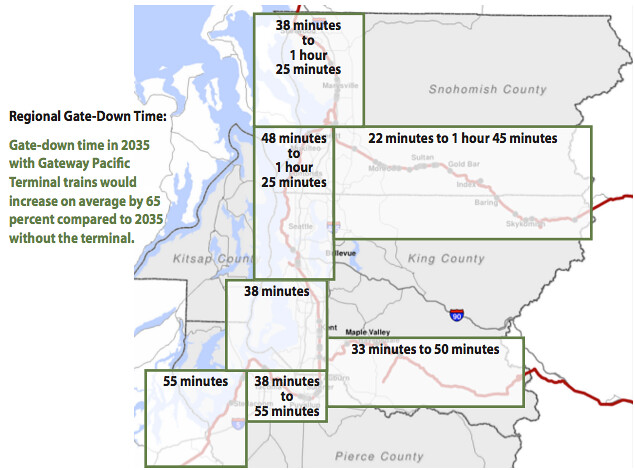
Anticipated delays caused by Gateway Pacific Terminal train traffic A new study commissioned by the Puget Sound Research Council anticipates the 18 additional coal trains per day to and from the proposed Gateway Pacific Terminal would create delays at rail crossings.’
The Gateway Pacific project would increase delays at rail crossings between 38 and 85 minutes, according to the study. Those delays could be nearly three hours by 2035 without rail system updates. Rail traffic is expected to increase regardless of whether the terminal becomes operational, and the study did not account for the simultaneous increase in rail traffic of crude oil, which has also caused delays on the region’s rail lines.
Terry Finn, a retired BNSF Railway lobbyist who serves on one of the council’s advisory boards, said in a letter to the council that its study was the latest attempt by opponents to use scare tactics to stop the coal project.
The completed terminal could force an upgrade of existing rail lines, which would instead boost the region’s economy, according to the study.
A business coalition formed to advocate for coal exports called the Alliance for Northwest Jobs & Exports issued a statement in response to the report.
It said that the report’s overall conclusions are not supported by the facts and that “greatly exaggerated costs projected in the study just don’t add up.”
Kathryn Stenger, a spokeswoman for the alliance, said in an email that other studies have concluded that the Gateway Pacific Terminal would economically benefit the entire region. The Washington State Farm Bureau, Association of Washington Business, and Washington State Labor Council have all endorsed Gateway Pacific, she said.
A separate economic study done for the Washington Farm Bureau in 2013 concluded coal terminals would result in lower costs and new markets for other Washington businesses.
BNSF Railway says it is investing approximately $235 million in Washington state this year to expand rail capacity and to replace and maintain network infrastructure.
There are 77 crossings in cities and towns in the Puget Sound area. Kent Mayor Suzette Cook said they present a safety issue as train traffic increases.
“At grade crossings are also a major problem with deaths. We’ve had several deaths occur on our tracks within the last year,” Cook said. “Cities are not in a position to shoulder the cost because other than avoidance of tragedy, the benefits are not there.”
Citizens trying to stop the piping of tar-sands oil through their community wore blue “Clear Skies” shirts at a city council meeting in South Portland, Maine, this week. But they might as well have been wearing boxing gloves. The small city struck a mighty blow against Canadian tar-sands extraction.
“It’s been a long fight,” said resident Andy Jones after a 6-1 city council vote on Monday to approve the Clear Skies Ordinance, which will block the loading of heavy tar-sands bitumen onto tankers at the city’s port.
The measure is intended to stop ExxonMobil and partner companies from bringing Albertan tar-sands oil east through an aging pipeline network to the city’s waterfront. Currently, the pipeline transports conventional oil west from Portland to Canada; the companies want to reverse its flow.
After an intensely debated, year-and-a-half battle, the South Portland City Council on Monday sided with residents like Jones who don’t want their city to end up as a new “international hub” for the export of tar-sands oil.
Dan WoodProponents of the Clear Skies ordinance, wearing blue, packed a South Portland city council meeting on July 9.
“The message to the tar sands industry is: ‘Don’t be counting your chickens yet,’” said Dylan Voorhees, clean energy director for the Natural Resources Council of Maine. “There is a pattern of communities saying ‘no’ to the threat of tar-sands oil.”
A clear signal
The ordinance could have global implications. The Canadian government expects the nation’s oil industry to be producing 4 million to 6 million barrels of tar-sands bitumen a day within a few years, and it’s pinning its hopes on somehow getting all that oil to coastal ports, said Richard Kuprewicz, president of Washington-based pipeline safety consulting firm Accufacts Inc. Indeed, a recent report from the International Energy Agency found that the industry needs export pipelines in order for its boom to continue.
South Portland’s move is just the latest setback for plans to pipe the bitumen out to international markets. Another big hurdle is the long delay over the Keystone XL pipeline. And in Canada, pipeline plans have met with opposition from indigenous peoples (known as First Nations), who are taking the lead to stop projects like the Enbridge Northern Gateway tar-sands pipeline through British Columbia.
Now, there is a clear signal that communities along the U.S. East Coast will fight tar-sands expansion too.
“Do not under estimate the power of a local government,” said Kuprewicz.
“A lot of perseverance”
In early 2013, residents formed Protect South Portland to try to stop the Portland-Montreal Pipeline reversal. They put an initiative on the November 2013 ballot to block the project, but it lost narrowly at the polls.
So the city council took up the cause. In December of last year, the council voted to impose a six-month moratorium on shipping tar-sands oil out through its port. Then a council-appointed committee crafted the Clear Skies Ordinance to permanently block tar-sands shipments, which is what the council officially approved this week. The law also changes zoning rules to block the construction of twin smokestacks that would be needed to burn off bitumen-thinning chemicals before the oil could be shipped out.
Over the past few months, concerned residents met in homes and Protect South Portland grew. Meanwhile, the group Energy Citizens, backed by the American Petroleum Institute, the oil industry’s largest trade group, ran ads that said “It’s just oil. From Canada.” The oil companies hired a number of lawyers and brought public relations firms on board.
Protect South Portland spokeswoman MJ Ferrier estimates that the grassroots group was outspent by at least 6 to 1.
So how did residents win over Big Oil? “A lot of perseverance and a lot of community engagement,” Voorhees said.
After the vote, supporters of the ordinance went to a local bar, and “we raised our glasses,” Jones told Grist.
Cautious celebration
But while local activists are celebrating this week’s win, they know “this is not the end,” said Jones.
South Portland Councilor Tom Blake, who’s been a champion of the effort to protect the city from tar sands, said a legal challenge seems imminent, by either Portland Pipe Line Corp., a subsidiary of ExxonMobil, or by the Canadian government. Blake had this message for the oil company and Canadian officials Monday evening: “This ordinance is the will of the people,” he said. “Do not spend millions of dollars and force the city of South Portland to do the same.”
But the oil interests are unlikely to heed his warning.
Tom Hardison, vice president of Portland Pipe Line, told reporters that the city had made a rush decision and bowed to environmental “off-oil extremists.” He added that the zoning changes amounted to a “job-killing ordinance” that prevents the city’s port from adapting to meet the energy needs of North America.
Matthew Manahan, attorney for Portland Pipe Line, told the city council before the vote that its ordinance is “illegal” and “would clearly be preempted by federal and state law.”
“The council is ignoring the law” and “ignoring science,” the lawyer added.
Air and water worries
Like the process of extracting tar-sands oil, the process of transporting it takes a huge toll on the environment. Before the heavy, almost-solid bitumen can be sent through pipelines, it has to be thinned with a concoction of liquid natural gas and other hydrocarbons. And then before it can be loaded onto ships, that concoction has to be burned off. ExxonMobil currently holds permits to build two smokestacks on South Portland’s waterfront that would do the burning.
Ferrier, a retired psychologist and a nun, joined Protect South Portland largely out of concern for what the oil companies’ plans would do to air quality in an area that has already received a “C” for ozone pollution from the American Lung Association. The proposed smokestacks would emit volatile organic compounds (VOCs). “We know there is benzene in it, a known carcinogen,” said Ferrier.
Resident Andrew Parker had similar concerns. “Tonight is about children,” he said at Monday’s city council meeting. “The oil company will put poison in the air, that is a fact.”
For Mayor Gerard Jalbert, who also sits on the city council and voted in support of the ordinance, it came down to concerns about water quality. The risk of water contamination in the case of a spill far outweighed the nebulous claims about job creation.
“When I look at the economic benefit, which no seems to be able to detail, the risk seems to outweigh the benefit,” Jalbert told Grist.
The easternmost 236-mile stretch of pipeline crosses some of the most sensitive ecosystems in Maine, including the Androscoggin River, the pristine Crooked River, and Sebago Lake, which supplies drinking water for 15 percent of the state’s population.
Blake, the council member, is worried that using old pipes to transport heavy bitumen could lead to a spill like the one that happened in Mayflower, Ark., in March 2013, when an ExxonMobil pipeline built in the 1940s ruptured and spilled hundreds of thousands of gallons of tar-sands oil.
Saying “no” to tar sands is part of a bigger shift to a greener future in South Portland, Blake added. “Being a community that has been heavily dependent on petroleum, this turns a tide,” the councilor said.
He pointed to a new electric-car charging station at the city’s community center and potential plans to build a solar farm on an old landfill as steps toward a sustainable future. “I think we are starting to walk the talk,” Blake said.
Roger Drouin is a freelance journalist who covers environmental issues. When he’s not reporting or writing, he is out getting almost lost in the woods. He blogs at rogersoutdoorblog.com.
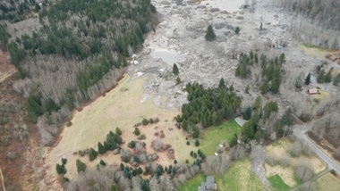
A photo taken immediately after the March 22 slide that killed 43 people and destroyed dozens of homes in Oso, Washington. A new scientific reports says a history of landslides and a huge volume of precipitation were big contributors to the slide. | credit: Washington Department of Transportation
SEATTLE — Scientists have concluded that rain, groundwater seepage and a long history of big landslides likely contributed to the massive landslide of March 22 that killed 43 people and destroyed dozens of homes near Oso, Washington.
Those findings came out Tuesday, the result of a scientific team’s rapid-fire assessment of geology and localized factors.
Joe Wartman, a University of Washington associate professor of civil and environmental engineering and a co-lead author of the study, said rainfall very likely played a key role in the slide.
“It mobilized as the water entered the landslide mass. It raised the water pressure in that mass,” Wartman said, “And as a result the landslide mass lost its strength and it became a fluidized mass of earth and material.”
The U.S. Geological Survey estimates that 7.6 million cubic meters of earth slid down across the Stillaguamish River, spreading out for more than a kilometer.
The researchers also looked further back in history, reviewing evidence from a number of large landslides in the Stillaguamish Valley around Oso during the previous 6,000 years. The team estimated that, based on a review of carbon dating and maps of 15 similar historic landslides nearby, slides such as the March event have happened in the same area as often as every 400 to 1,500 years historically.
“The real different thing about that particular spot was how much it had failed in the very recent past,” said Dave Montgomery, a geomorphologist with the University of Washington and co-author of the report. “It had been chewed on a lot by prior failures.”
A 2003 lidar map of ground conditions where the Oso slide occurred.
The report authors said the landslide occurred in two phases. The first slope failure was a repeat of previous slides that had been documented as far back as the 1950s at that site. The most recent one to contribute to the March slide took place in 2006.
The second phase of the March 22 event tapped into a much deeper landslide history at the site.
“You have the really big ones from thousands of years ago,” Montgomery said, “But why did the piece of the slope fail that did? It was different from some other areas up and down the valley due to the history of failure in recent decades, which exacerbated the stability problem.”
The report raised a question that was brought up in the immediate aftermath of the slide: what role did logging play? But the authors said that they were “not in a position to answer the question of what degree forest practices contributed to this slide.” Any conclusions would require further modeling and were beyond the scope of this four-day reconnaissance effort, they said.
Logging can contribute to weakened root strength, allowing hillsides to slough off in heavy rain. But Montgomery said the team was pretty comfortable ruling out that idea because the slide was too big and roots would have been too thin to make a difference in preventing the massive amount of earth from loosening.
Another potential connection to logging is from the removal of trees that would otherwise have absorbed some of the precipitation, preventing it from seeping deep into the soil and loosening it. Groundwater seems to have been a key contributor to the destabilization of the slope near Oso, the report authors concluded. Montgomery said the team saw seeps of water coming into the exposed face, or scarp, of the landslide from neighboring creek basins to the east.
“We located five or six groundwater seeps where water is coming out of the wall of the slide and forming a little stream that is running across the scar,” Montgomery said. That stream could have destabilized the earth far below the surface of the slide, contributing to its size and extensive runout zone.
The authors concluded that methods to identify and predict potential landslide runout zones need to be revisited and re-evaluated. The use of LIDAR imagery could also provide a great deal of assistance in gathering historic evidence that landslides of this magnitude have run across the valley before, said Jeff Keaton, a principal engineering geologist with AMEC Americas, who contributed to the report.
“That would be a really helpful step in understanding how widespread this kind of process actually is,” he said.
But there’s more digging to be done, literally, said Joe Wartman.
“The hole we have at this point is understanding what was going on underneath the ground surface,” Wartman said. “I think the next big thing is drilling holes into that landslide and the nearby vicinity to get an understanding of what is underneath that large landslide.”
The authors called for further modeling in order to better understand to what degree logging or the Stillaguamish River, which was eating away at the toe of the slope, may have contributed to the catastrophic slide.
The USGS and others will be conducting field research in the coming months. You can read the full report here.
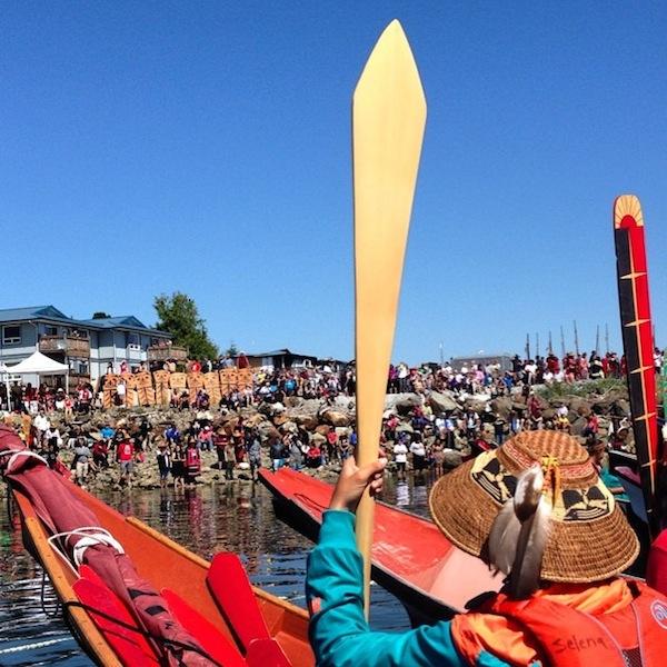
Tracy Rector/Longhouse Media The Heiltsuk First Nation is hosting 31 canoes from Pacific Northwest indigenous nations. That number was provided by the manager of the Paddle to Bella Bella Facebook page. Canoes arrived July 13; the week of cultural celebration continues through July 19.
En route to the territory of the Heiltsuk First Nation, pullers in the 2014 Canoe Journey traveled through territory so beautiful it will be impossible to forget: Rugged, forested coastlines; island-dotted straits and narrow, glacier-carved passages; through Johnstone Strait, home of the largest resident pod of orcas in the world, and along the shores of the Great Bear Rainforest, one of the largest remaining tracts of unspoiled temperate rainforest left in the world.
They also traveled waters that are increasingly polluted and under threat.
Pullers traveled the marine highways of their ancestors, past Victoria, British Columbia, which dumps filtered, untreated sewage into the Salish Sea. They traveled the routes that U.S. energy company Kinder Morgan plans to use to ship 400 tanker loads of heavy crude oil each year.
Canoes traveling from the north passed the inlets leading to Kitimat, where heavy crude from Enbridge Inc.’s Northern Gateway pipeline would be loaded onto tankers bound for Asia, a project that Canada approved on June 17.
Canoes from the Lummi Nation near Bellingham passed Cherry Point, a sacred and environmentally sensitive area where Gateway Pacific proposes a coal train terminal; early site preparation was done without permits and desecrated ancestral burials.
Canoes from Northwest indigenous nations arrived in Bella Bella, British Columbia on July 13; the gathering continues until July 19 with cultural celebrations, a rally against Enbridge’s Northern Gateway pipeline, and an indigenous economic summit. The ceremonies are being livestreamed online at Tribal Canoe Journeys 2014 :: Qatuwas Bella Bella.
Mike Williams Sr., chief of the Yupiit Nation and member of the board of First Stewards, noted that the Canoe Journey route calls attention to the fragile environment that’s at stake. First Stewards, an indigenous environmental advocacy group, will host a symposium on “Sustainability, Climate Change & Traditional Places” from July 21–23 in Washington, D.C.
“The Canoe Journey is a really big statement to us to hang onto our culture and our way of life, and to bind people together,” said Williams, who is also a well-known musher. “In the Iditarod, there are pristine places but there are also old mining towns [on the route] where we’re told not to drink the water.”
The parallels between the water issues encountered on the Iditarod and the Canoe Journey are unmistakable, he added.
“In the Canoe Journey, there are pristine waters and there are waters that contains toxic substances,” Williams said. “There’s oil and the continuous leaking of pipelines. It happens.”
Not only does it happen, but it does not go away. Prince William Sound has never totally recovered from the Exxon Valdez oil spill, Williams said. Likewise, he added, if the Northern Gateway pipeline, the coal trains and increased shipping come to fruition, an environmental disaster is inevitable.
“It’s going to happen,” Williams said. “There has to be total, thoughtful conversation for everyone—consider all the possible impacts. And there has to be meaningful consultation with the tribes. They have to weigh in on that. We’ve got to make it 100 percent fail-safe or don’t do it.”
The Heiltsuk First Nation’s hosting of the 2014 Canoe Journey included a rally against the Enbridge pipeline. Canoes arrived in Bella Bella, B.C., on July 13; the week of cultural celebration continues through July 19. (Photo: Tracy Rector/Longhouse Media)
State Senator John McCoy, D-Tulalip, is a citizen of the Tulalip Tribes. He is the ranking member of the Senate Energy, Environment & Telecommunications Committee, which focuses on such issues as climate change, water quality, toxic chemical use reduction and cleanup, and management of storm water and wastewater.
“I think the message is, pollution is occurring everywhere,” McCoy said of the takeaway from the Canoe Journey. “It’s a worldwide problem, and it needs to be addressed. If we keep polluting our water, we’re going to be in big trouble. Water is the essence of life.”
Canoes were underway for Bella Bella on July 9 as Governor Jay Inslee announced that he wants to increase the recommended fish-consumption rate in the state from 6.5 grams to 175 grams a day—that’s good news for indigenous peoples, for whom fish is important culturally, spiritually and as a food. But for 175 grams of fish to be considered safe to eat, businesses that pollute will have to conform to tougher pollution control standards.
Inslee’s plan for how toxic substances will be controlled in expected in December. It will require legislation, McCoy said.
Jewell James is coordinator of the Lummi Treaty Protection Task Force and a leader in the effort to prevent a coal train terminal from being built at Cherry Point, a sacred area for the Lummi people and an important spawning ground for herring, an important food for salmon.
James said environmental degradation is just part of a series of historical traumas set upon Indigenous Peoples: First, the diseases that came after contact; then the treaty era and the relocation to reservations; then the cultural and spiritual oppression of the boarding school era, and then the termination era.
“Yet we continue to exist,” James said. And the Canoe Journey, now in its 23rd year, has helped “revitalize and breathe new life into our cultural knowledge” given that journey gatherings are venues for the passing down of stories about how the ancestors lived in and cared for the environment that sustained them.
James hopes people on the Canoe Journey connect with and carry on those stories and values.
“There are messages in those stories,” he said. “And within those stories there are sacred symbols that mean something—that you have to be careful with what you do, and others have to be careful with what they do, to Mother Earth.”
Indigenious to the Pacific Northwest, Oregon-Grape resembles the Holly with its green leaves and produces deep bluish purple berries that have a tart taste when consumed, and are part of the traditional diet of tribes located in the Pacific Northwest. Photo/ Brandi N. Montreuil
Spotlight on the Oregon-Grape
By Brandi N. Montreuil, Tulalip News
You might have noticed the blooming of flowers, foliage, and other plant species occurring as our summer season kicks into high gear. The abundance of sunshine has increased outdoor activities where these blooming specimens have been the main attraction for people out for a stroll.
As you grab your walking shoes to enjoy some of that summer sun, keep your eyes peeled for a flowering plant native to western North America called the Oregon-Grape, or M. aquifolium for you plant enthusiasts.
The Oregon-Grape is a cousin to the Goldenseal plant and known to be bitter due to a presence of alkaloids including berberine. There are many types of Oregon-Grape, but the tall variety can grow up to 8 feet tall, while the dwarf variety will only grow a few feet in height. Other types include cascade, low, and creeping Oregon-Grape.
All varieties feature stiff branches with leaves that will remind you of Holly with their glossy prickly leaves, which are deep green on top and silvery underneath. Flowers are yellow and bloom in late spring, followed by the presence of small bluish-black berries sprouting in clusters from its branches resembling true grapes, from which it takes its namesake. Berries, ripe from July until September, and have a tart taste with earthy undertones.
As a Northwest perennial, Oregon-Grape is prized for its beauty and heartiness which has made it an excellent choice for city landscapers.
The plant also has a variety of medicinal uses thanks to that bitterness, which has been used by Coast Salish tribes to help stimulate liver function, aid digestion, and used as a laxative.
Oregon-Grape is a great addition to gardens with its vibrant foliage, flowers and berries which will create a colorful splash in shady or woodland plantings. Its ability to survive summer droughts and its tolerance for poor soils make it an easy plant for gardeners to enjoy.
Oregon-Grape is used in herbal remedies for infections and to improve digestion and live function. Photo/ Brandi N. Montreuil, Tulalip News
Oregon Grape planted near the Tulalip Administration Building is used as a natural filter to clean water runoff before it reaches the Tulalip Bay, and should not be harvested for traditional use. Photo/ Brandi N. Montreuil, Tulalip News
So far, more than 150 homes in Washington state have been destroyed in what veteran firefighters are calling the worst fire season in decades.
Fires have scorched thousands of acres of ranchland in southeast Oregon.
Credit Brooke Nyman / Oregon Cattleman’s Association
In neighboring Oregon, firefighters are stretched thin by more than a dozen blazes burning at once.
Veteran firefighter Al Lawson came to a community meeting in central Washington to meet with residents displaced by the raging Carlton Complex Fire. It’s among the largest wildfires in the state’s recorded history.
“In my 30 years, I’ve never seen fire behavior like this,” he said. “Nothing to compare.”
Governor Jay Inslee toured the devastation over the weekend. He called it an unprecedented firestorm.
“Our state is stretched beyond imagination,” he said.
Inslee says the fact that it’s only mid-July is an ominous sign.
“Typically the fire season doesn’t really get going until August,” he said. “So we have at least two more months in the fire season and we have already burned twice as many acres as the average.”
Oregon has been spared the same level of devastation in terms of lost property. But the Oregon Department of Forestry says so far the sheer number of acres burned this summer is seven times more than a typical fire season.
On a more positive note, the agency’s Cynthia Orlando says cooler weather for the next few days could help slow things down.
“We’re getting a lit bit of a respite but you know, everybody’s on alert here,” Orlando said.
Temperatures are expected to soar back into the 90s by the end of the week.
The conventional wisdom on climate change is that the issue is politically toxic. But it turns out the American people may be prepared for the kind of enormous undertaking that would be required to stem the catastrophic effects of climate change — including unilateral action by the U.S. government.
Last month, the Yale University Project on Climate Change Communication and the George Mason University Center for Climate Change Communication published “Politics and Global Warming,“ a massive survey of 860 registered voters on the subject of the government’s role in fighting climate change. While the results appear to confirm that there is still a strong partisan divide on the issue, there is, as the report authors state, “much more going on beneath the surface.”
Perhaps the most crucial finding is that 62 percent of respondents are not content to have the U.S. wait on the sidelines unless and until other nations commit to emissions cuts. All but the most conservative of respondents said the U.S. should reduce its emissions “regardless of what other countries do.” Climate change skeptics have long argued that anything the U.S. does will not count for much if large polluters like India and China do not also take steps to curtail their carbon output. The Obama administration has argued that the U.S. has to exhibit leadership on emissions cuts (most recently through Environmental Protection Agency rules on existing and new power plants), and that the U.S.’s credibility at forthcoming climate talks in Paris rests on a demonstration of American commitment.
The poll numbers suggest many Americans intuitively understand this. The partisan breakdown is intriguing: While Democrats (especially liberals) are solidly behind this flavor of American unilateralism, Republicans are divided: 57 percent of self-described liberal and moderate Republicans would support that effort.
The poll also suggested fairly wide acceptance of several other benefits of emissions reductions, including public health improvements, energy self-sufficiency, and poverty reduction. There is fairly broad agreement that taking steps to reduce global warming will “[p]rovide a better life for our children and grandchildren,” a catch-all statement that indicates Americans are willing to make some sacrifices now in exchange for benefits down the line.
More concretely, most people seem to buy into the EPA’s argument that its emissions reduction plans will have public health benefits (54 percent total; 72 percent among Democrats and 46 percent among Republicans), an improvement from a previous Bloombergpoll that asked the same question.
Many Americans also look forward to climate action reducing dependence on foreign oil (55 percent total), though so far there is no climate-related public policy intervention in the offing that would drastically reduce oil consumption. The EPA regulations affect power plants, very few of which are oil-fueled, and our declining oil imports over the past half decade can largely be attributed to domestic drilling efforts, especially extraction of tight and shale oil. The polling suggests, however, that the American people closely correlate the end-result of climate action with energy security.
The only result that may give climate hawks pause was the benefit that polled as the least popular: That addressing climate change would improve U.S. national security. Even among liberal Democrats, it is not an easy sell (47 percent); it does not even break 30 percent with moderate or conservative Democrats and only 24 percent for Republicans as a whole. Previous studies show that adopting this frame is unlikely to convince conservatives to take climate change seriously (David Roberts has written previously on the “boomerang effect” of such arguments). Indeed, only on poverty reduction is there less agreement than national security improvement.
The belief that climate change and national security are not interrelated is prevalent despite repeated warnings from the U.S. intelligence and defense communities. As The Week‘s Ryan Cooper put it in a recent piece, the imperatives for risk management and self-preservation with regard to climate change are understood very well among the military. There are two points worth making about this.
The first is that it is a relatively novel and recent development to think about climate change in national security terms. People typically think of climate change as an environmental problem, rather than a security one, so it is no surprise that saving plant and animal species and preventing destruction of life scores much higher. Additionally, aside from military responses to natural disasters — such as the 2004 Indian Ocean tsunami or the 2013 typhoon that devastated parts of the Philippines — there is no headline event that would cause people to link climate and national security.
The second point is that, on some level, the fact that public opinion is not catching up with some sectors of elite opinion is not necessarily an immediate cause for concern. That the argument is not making inroads with Main Street is less of a problem than it not influencing policy in executive departments. While Congress has abdicated its responsibility on climate change legislation, the Obama administration has been pro-active.
Still, what these findings suggest is that the steady drumbeat of analysis on climate change is having a positive effect. People are generally aware there is a problem, and are generally supportive of policies to fight it, even going so far as to say the U.S. can strike out ahead of other countries. People also recognize that benefits will accrue in such a way as to eventually justify the cost. While there is still a motivated minority resisting these findings, the Yale–George Mason report confirms they are nothing more than that: A minority.
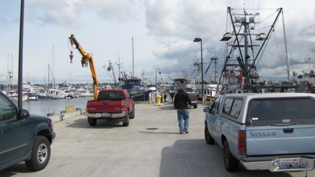
A 2012 file photo of Fisherman’s Terminal in Seattle bustling as ships get ready to head to Alaska for the summer fishing season. Hundreds of Northwesterners hold commercial fishing permits for Bristol Bay. | credit: Ashley Ahearn
by: Associated Press
JUNEAU, Alaska (AP) — The U.S. Environmental Protection Agency said Friday it is proposing restrictions that would essentially block development of a planned massive gold-and-copper mine near the headwaters of a world premier salmon fishery in Alaska.
The announcement came as the EPA was being sued by Pebble Limited Partnership, the group behind the proposed Pebble Mine, and the state of Alaska for allegedly exceeding its authority.
The state and Pebble Partnership, which was created to design, permit and run the mine, argue the EPA should not be able to veto the project before a mine plan is finalized and evaluated through the permitting process. Pebble has asked that a judge block the EPA from taking any additional steps, but no ruling has been made.
EPA regional administrator Dennis McLerran said the science is clear “that mining the Pebble deposit would cause irreversible damage to one of the world’s last intact salmon ecosystems. Bristol Bay’s exceptional fisheries deserve exceptional protection.”
The EPA said as part of its analysis it used plans filed by the mine’s owner, Northern Dynasty Minerals Ltd., with the U.S. Securities and Exchange Commission in 2011. That information indicated the Pebble deposit is likely to involve excavation of the largest open pit ever built in North America, reaching a depth that rivals that of the Grand Canyon at nearly a mile, the EPA said in its report.
The agency looked at three mine scenarios, one based on the worldwide median size deposit that contains copper-, gold- and molybdenum-bearing minerals, which was the smallest scenario analyzed, and two that it said were based on statements made by Northern Dynasty, of mine sizes of 2 billion tons and 6.5 billion tons.
The restrictions proposed by EPA are in line with the estimated impacts of the smallest scenario, including loss of at least 5 miles of streams with documented salmon or loss of 1,100 or more acres of wetlands, lakes and ponds that connect to salmon-bearing streams or tributaries of those streams.
The EPA said if the proposed restrictions were finalized, mining of the Pebble deposit would still be possible, but only if the environmental impacts were smaller than those laid out.
U.S. Sen. Mark Begich, D-Alaska, who has said Pebble is the wrong mine in the wrong place, said he’s seen noting in the EPA document that would prevent Pebble from applying for a permit.
“Instead, it sets the ground rules for responsible development that the Pebble Partnership, or any other business, must abide by in order to mine the Pebble deposit in this critical habitat,” he said.
The EPA called its analysis conservative, focused on the use of certain waters in the region for disposal of materials associated with mining the Pebble deposit. The agency said it did not include impacts associated with build-out and operation of a mine, like roads, pipelines and housing for workers, or potential effects of accidents or mine failures.
The EPA also said the proposal is specific to the Pebble deposit, and does not affect other deposits or claims.
In 2011, the EPA, petitioned by Alaska Native tribes and others to protect Bristol Bay, initiated a review that culminated in the finding earlier this year that large-scaling mining in the Bristol Bay watershed posed significant risks to salmon and Alaska Native cultures that rely on the fish. The agency later invoked a rarely-used process through which it could ultimately restrict or prohibit development of the proposed Pebble Mine to protect the fishery.
The announcement Friday is the next step in that process. EPA plans to take public comment beginning Monday through Sept. 19 and to hold public meetings in Alaska next month. After that, McLerran would have to decide whether to withdraw the proposed action or send it to EPA headquarters for consideration.
Tom Collier, CEO of the Pebble Partnership, said while his group needed to analyze EPA’s proposal, it was outraged that the agency took this next step with litigation pending and EPA’s inspector general reviewing whether EPA followed laws, regulations and policies in developing its watershed assessment.
“We will continue to fight this unprecedented action by the Agency, and are confident we will prevail,” he said in a statement.
Newtok Planning Group The Alaska Native village of Newtok is one example of an indigenous community at the forefront of climate change. Erosion due to rising sea levels has required the relocation of the entire village.
President Barack Obama on July 16 released another set of climate-change-resilience guidelines, this batch geared specifically toward tribes, and announced the allocation of $10 million to help tribes cope with climate change.
The allocation was one of a number of measures announced at the final meeting of the White House State, Local, and Tribal Leaders Task Force on Climate Preparedness and Resilience, created by Obama last fall. Karen Diver, chairwoman of the Fond du Lac Band of Lake Superior Chippewa in Minnesota, and Reggie Joule, mayor of the Northwest Arctic Borough in Alaska, were the tribal officials designated to serve on the task force.
The money will fund the development of resource management methods, climate-resilience planning, and youth education and empowerment. Climate adaptation grants will also be awarded for the development of climate-adaptation training programs, assessment of vulnerability, monitoring and other aspects of learning about the effects of climate change. Adaptation planning sessions will be offered, and tribal outreach will be funded with the money as well, Interior said. Administration officials said such measures are sorely needed.
“From the Everglades to the Great Lakes to Alaska and everywhere in between, climate change is a leading threat to natural and cultural resources across America, and tribal communities are often the hardest hit by severe weather events such as droughts, floods and wildfires,” said Secretary of the Interior Sally Jewell, chair of the White House Council on Native American Affairs, in a statement. “Building on the President’s commitment to tribal leaders, the partnership announced today will help tribal nations prepare for and adapt to the impacts of climate change on their land and natural resources.”
Obama has been highlighting the effects of climate change on Native peoples in his efforts to construct a plan for dealing with the inevitable changes.
“Impacts of climate change are increasingly evident for American Indian and Alaska Native communities and, in some cases, threaten the ability of tribal nations to carry on their cultural traditions and beliefs,” said Assistant Secretary of Indian Affairs Kevin Washburn. “We have heard directly from tribes about climate change and how it dramatically affects their communities, many of which face extreme poverty as well as economic development and infrastructure challenges. These impacts test their ability to protect and preserve their land and water for future generations. We are committed to providing the means and measures to help tribes in their efforts to protect and mitigate the effects of climate change on their land and natural resources.”
The Interior Department will also team up with the U.S. Environmental Protection Agency (EPA) to create a subgroup on climate change under the White House Council on Native American Affairs, the DOI said. This cooperation between Jewell and EPA Administrator Gina McCarthy will entail working with tribes to pool data and information on climate change effects that are directly relevant to issues faced by American Indians and Alaska Natives. Traditional and ecological knowledge will be a cornerstone of the initiative.
“Tribes are at the forefront of many climate issues, so we are excited to work in a more cross-cutting way to help address tribal climate needs,” said McCarthy in the statement. “We’ve heard from tribal leaders loud and clear: when the federal family combines its efforts, we get better results—and nowhere are these results needed more than in the fight against climate change.”