TULALIP — The Marysville School District’s third annual Opportunity Expo is coming on Tuesday, April 22.
The Expo is a dynamic college and career fair designed to help prepare students for life after high school.
The event will take place at the Tulalip Resort Orca Ballroom and Chinook rooms from 8 a.m. to 3:30 p.m.
There will be three sessions for students — 8 a.m., 9:45 a.m. and noon — and one session open to parents, students, staff and community members at 1:45 p.m.
Marysville School District juniors will be bused to the morning sessions.
The Expo is provided through a partnership between the Marysville School District, the Tulalip Tribes, the Marysville Rotary and the Rotary Education Foundation.
More than 120 college, tech, trade, vocational, civic and military representatives will be in attendance, to help students prepare for their futures, and support them in their dreams and goals.
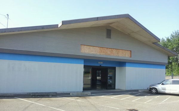
After nearly eight months of work, the Red Curtain Foundation for the Arts has completed
Phase 1 of the project to transform a large commercial building at 1410 Grove Street in Marysville into a community art center. To celebrate, an official ribbon-cutting ceremony is planned for Monday, April 21, at 1 p.m.
The non-profit arts education organization moved into the building, which formerly housed Dunn Lumber, in August of 2013, and has spent the past eight months raising funds, doing community outreach, and renovating the former lumber store.
Phase 1 consisted of the installation of a monitored fire alarm system, upgrading an existing restroom to more closely meet ADA standards, safety upgrades that included emergency lighting, cosmetic and clean-up work, and other minor improvements. The organization was able to raise the funds for this phase through private donations, grants, a crowdfunding campaign through Indiegogo, and a donors’ luncheon.
With this first phase completed, Red Curtain will open the building for arts classes and meetings. The facility will be available for some rentals, but there are still usage limitations until the installation of a fire sprinkler system and the addition of new restrooms.
At the ribbon-cutting on Monday, Mayor Jon Nehring will officially welcome the public to the new community arts center. Other guests who may be in attendance include Superintendent of Marysville School District Becky Berg, Kenneth Kettler from the Tulalip Casino, and members from the Kiwanis, the Sunrise and Noon Rotaries, Soroptomists, Marysville Public Library, and the Marysville Arts Coalition.
The Spring Session of classes will begin that day with piano lessons by Stephanie Bowsher in the afternoon and Adult Acting Class, taught by Red Curtain founder and board president Scott B. Randall, that evening. Other classes offered this spring are Acting Potpourri by Hollywood veteran Steven Marlo, Shakespeare by Jay Rairigh, and Mid-Century Playwrights, also taught by Randall.
TAHOLAH, WA (4/15/14)– The Quinault Indian Nation (QIN) Business Committee passed regulations Monday night to reopen Lake Quinault to non-tribal use, but only under specified regulations and restrictions, according to Fawn Sharp, QIN President.
The lake, which belongs to the Quinault Nation, was closed to non-tribal use on June 6, 2013 to safeguard it from pollution, invasive species and other issues of concern. Since that time, numerous nearby non-tribal residents, property owners and business owners in the area have spoken out in support of the Tribe’s actions, saying they appreciate the work being done by Quinault to protect the lake for future generations.
“That has always been our intent,” said Sharp. “Safeguarding our sacred lake for our children and for all the life it sustains is one of our highest priorities. If we can achieve those objectives, and share this precious resource with our non-tribal members, that’s what we will do. We believe it is time to try.”
The Quinault Business Committee passed the Lake Quinault 2014 Fishing, Boating and Use Regulation 2014-01, which allows uses of and on Lake Quinault for a one year time span.
Lake Quinault is located within the boundaries of the Quinault Indian Reservation and is owned up to the Ordinary High Water Mark (OHWM) entirely by the QIN; all persons who enter onto Lake Quinault, within the boundaries of the OHWM, are required to conform to Quinault tribal laws. Violators who resist or refuse to obey will be subject to confiscation of all gear and boats and enforcement under the Quinault Tribal Code in the Quinault Tribal Court at Taholah.
Something I have always dreamed about has become a reality. It is called an agrihood, a residential neighborhood with a farm at the center—not a golf course, club house or pool, but something really sensible: fresh, organic food!
My dream of long ago was to buy up a large track of land in New England where I live, invite family and friends to invest, and build homes around a central place to grow our own food and be self-sustainable.
In one model neighborhood called Agritopia, a small community based near Phoenix that currently counts 152 families, grows fruit trees, grapes and raises animals. For copy00 per month, members go to the town farm to pick up groceries. The central “square” also functions as a community hub with a coffeehouse and a farm-to-table restaurant, according to The New York Times. Agritopia is also in the process of creating “Generations at Agritopia” for independent and assisted living.
Now many other agrihoods are popping up across the country, such as Serenbe in Chattahoochee Hills, Georgia; Prairie Crossing in Grayslake, Illinois; South Village in South Burlington, Vermont; and Hidden Springs in Boise, Idaho.
“I hear from developers all the time about this,” Ed McMahon, a senior fellow for sustainable development at the Urban Land Institute, a nonprofit real estate research group in Washington, D. C., told the Times. “They’ve figured out that unlike a golf course, which costs millions to build and millions to maintain, they can provide green space that actually earns a profit.” In addition, community residents get a potential tax break for preserving agricultural land.
Agrihoods fulfill a need for people who want open space and fresh air, and lush fields of organic crops, near an urban center. One of the largest suburban farm consultants is Agriburbia in Golden, Colorado, and another near Atlanta, Georgia, called Farmer D Organics. Apparently these similar agencies are inundated with requests for information—and not just from developers but from golf course owners who are anxious to transfer their costly maintenance to a more profitable venture.
Some of these agrihoods have a central farm market, coffeeshop or restaurant, even craft shops, plus views of their food growing right before them. It gives the residents a sense of secure sustainability—healthy food for themselves and their children right in their own back yard, so to speak. The homes in these areas are no more expensive than similar homes nearby. Because one or two crops won’t cut it, these farms must be very diversified so they need a farmer who can understand the community’s needs. The farmer must plant a variety of crops to sell to residents, then have a good enough business sense to sell any excess to local chefs or farm markets. This farm-to-table initiative is growing all over the country.
In older times this way of living would be called tribal. Sharing food grown with all, caring for elders and children first. We Native Americans were not impoverished when we fed ourselves without so much government help. Health and nutrition, food production and economic growth on reservations is now pretty sad. Even here there is new hope in the projects funded by First Nations Development Institute, Native Agriculture & Food Systems Initiative (NAFSI), Native American Food Sovereignty Alliance and other smaller educational grants. I mentioned several of these in my article Grow Food, Not Lawns! (February 22).
This spring will see many elementary schools in indian country involved in planning and planting their own gardens while learning agricultural practices to last a lifetime. The notion of agrihoods is so sensible for all people. Native communities have an edge because they are already a community; they only need to customize the residential side of this farm living to their needs. It will be very interesting to see how agrihoods play out in the coming years throughout the country.
Dale Carson (Abenaki) is the author of three books: New Native American Cooking, Native New England Cooking, and A Dreamcatcher Book. She has written about and demonstrated Native cooking techniques for over 30 years. Dale has four grown children and lives with them and her husband in Madison, Connecticut.
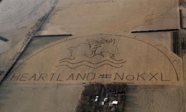
Lou Dematteis/Spectral Q, via Bold Nebraska The crop art image with HEARTLAND #NoKXL protests the proposed Keystone XL pipeline on a corn field outside of Neligh, Nebraska
It’s a message not from an alien species, but from opponents of the Keystone XL pipeline.
Last week a crop-art image the size of 80 football fields was installed along the controversial pipeline’s proposed path in Neligh, Nebraska. The image includes the bust of a man in a cowboy hat and an American Indian in a porcupine roach with two feathers. Under the pair of heads is an illustration of water waves and the text, “HEARTLAND #NoKXL.”
The massive art installation, which was executed by artist John Quigley in partnership with the anti-Keystone XL Pipeline Cowboy and Indian Alliance, is meant to tell President Barack Obama to protect the heartland and reject the pipeline, according to Bold Nebraska, a coalition of groups and individuals opposing the project.
Opponents argue that it will contaminate drinking water and pollute the soil. Conversely, proponents state it will bring jobs to the U.S. The project has been controversial from the start, and now that the decision is down to the wire, the opposition is digging in even further.
“Jobs are not worth the risk of the future of our land,” Tessa McLean, Anishinaabe, a member of the Colorado American Indian Movement and an Idle No More activist, told Indian Country Today Media Network. “Even if the pipeline is safe, even if it never ever spills, it still takes the rights away from land owners. It goes through Indian country, and we don’t want anything going through our country without [our] consent. And Indians will never consent.”
The section of pipeline that still needs approval would cross the border from Canada, where the viscous bitumen originates in the Alberta oil sands, and cut through Montana, South Dakota, Nebraska and Kansas.
Ranchers, farmers and Native Americans who live on the pipeline route plan to descend on Washington, D.C. and camp near the White House beginning on April 22, which is Earth Day, to encourage the president’s support, according to the Cowboy and Indian Alliance website. On April 26, thousands of opponents are expected to join the campers and protest the pipeline.
Several camps are already installed along the pipeline route in Indian country. Descendants of the Ponca Tribe erected a camp in Nebraska in November. A second was established on the Rosebud Sioux reservation on March 29, and the Cheyenne River Sioux Tribe opened one on Saturday April 12.
God has called another beautiful angel home. Jessica Christina Jones lived in Tulalip, WA and passed away on April 9, 2014 in Seattle, Washington at the age of 25. She was born in Everett, Washington on August 1, 1988 to Ralph D. Jones III and Pam Blount. Jessica was born to a fisherman. She helped her dad fishing, loved to draw, country music and her cats. She attended school in Marysville, Washington. She enjoyed her culture; working with her dad clam digging, fishing, canning, berry picking and planting trees. People found Jessica to be sassy, with a great sense of humor. She will be deeply missed by her family and friends. She loved the family vacations every summer to Uncle Deans and Aunt Marilyns farm in North Dakota so she could watch him milk the cows and go for rides on his quad. She always enjoyed Grandma Lyla’s dumpling soup. Jessica is survived by her mother, Pam Blount; stepfather Butch Blount; grandmother, Lyla Skaggs and Popa Harry Dishman; she leaves her son Aiden Echo Mather; brother, Cody Blount; and sister, Sonia (George) SoHappy; Aunts Kimberly Skaggs, Rae Anne (Mike) Gobin, Karen (Steve) Gobin; uncle Jimmy Jones (Kristie Lawrence); nieces Kylee, Kira and Kaliyah SoHappy, nephew Koli SoHappy; as well as cousins Shelby Cleveland, Justine Jones and Natosha Gobin; Brent, Ron, Josh Cleveland, Kevin (Lani) Jones, Steven Gobin Jr. and Brian Jones Jr. ; great aunts and uncles, Jane Wright, Herman Williams, Clyde and Maxine Williams, Arley and Charlene Williams, Marilyn Tietz, Harry and Shirley Schmidt, Scharlotte Walter; special cousins Felicia Stripling, Who was also like a sister; And many other cousins. Jessica is preceded in death by her father, Ralph D. Jones III; grandparents Dorraine and Ralph D. Jones Jr. Grandpa Hubert Skaggs; great grandparents, Ralph and Edith Jones and Lawrence and Christina (Daisy) Williams; great-great grandmother, Lena Harrison; great aunt, Genevieve Williams; great uncle, Darrell Ray Jones; and cousins Kevin Jones; and Nathan Cleveland. Viewing will take place at 1 p.m. on April 14, 2014 at Schaefer-Shipman Funeral Home in Marysville. An Interfaith Service to celebrate Jessica’s life will be held at 6:00 p.m. 2014 at Tulalip Tribal Gym.. Funeral Services to be held at 10:00 a.m. on Tuesday, April 15, 2014 at the Tulalip Tribes Gym followed by burial service at the Mission Beach Cemetery. Arrangements entrusted to Schaefer-Shipman Funeral Home.
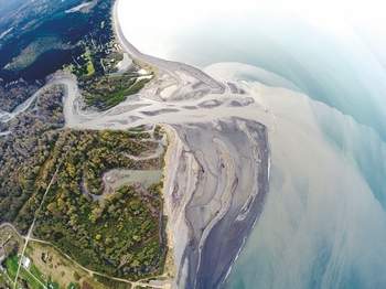
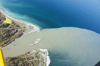
PORT ANGELES — What does roughly 3.3 million cubic yards of sediment look like?
The ever-changing mouth of the Elwha River can offer some clue.
Between November 2012 and September 2013, about 3.3 million cubic yards, or 2.5 million cubic meters, of sediment once locked behind two massive dams along the river has built up at the mouth of the river, according to U.S. Geological Survey data estimates.
The river, which begins in the Olympic Mountains, empties into the Strait of Juan de Fuca west of Port Angeles.
Ocean currents in the Strait and the force of the river itself continuously shape the Elwha’s maw, with the landscape changing on a monthly and weekly basis.
“The river mouth is just changing dramatically all the time,” said Ian Miller, a coastal hazards specialist with Washington Sea Grant.
Millions of cubic yards of sediment have been released from the bottom of the lakes that once bore the names Aldwell and Mills as part of the $325 million Elwha River dam-removal and restoration project begun in September 2011.
The 108-foot, century-old Elwha Dam, which once cradled Lake Aldwell, was completely removed by March 2012, while all but 30 feet remain of once-210-foot Glines Canyon Dam.
The sediment released by dam removal has built up so much at the river’s mouth that areas that were underwater before the dams were removed are now land for hikers.
“There has definitely been some added land, [some] new land created,” Miller said.
Miller is one of a battery of scientists scrutinizing the effects the restoration effort is having on the river’s body, mouth and surrounding environment.
Miller, who has been monitoring changes at the river mouth since dam removal began, said he will be part of a seven-person team the U.S. Geological Survey is organizing at the end of April to gather the most recent estimates of sediment built up there.
Miller said maybe 1 million cubic meters, or 1.3 million cubic yards, of sediment could have been added to the mouth this winter and early spring thanks to a wetter-than-normal February, another notch taken out of Glines Canyon Dam earlier this year and spring snow melt in the Olympic Mountains.
As sediment continues to course down the flowing Elwha, Miller said, the only sure thing about how the mouth looks is that it will change, likely for years to come.
Visit the mouth (watch where you walk!)
Want to see firsthand the dramatic ecosystem changes where the Elwha River spills into the open waters of Freshwater Bay?
From Port Angeles, go west on U.S. Highway 101 to its junction with state Highway 112.
Take Highway 112 west 2.1 miles (crossing the river) to Place Road.
Turn right (north) and follow Place Road 1.9 miles to the “T” intersection.
Turn right (east), go down the hill to the Elwha Dike access point.
Day-use parking is available along the road (note the signs). Follow the Dike Trail a couple hundred yards to the mouth.
This is also a popular surfing spot. Respect private property in the area.
Miller was at the river’s mouth Friday with University of Washington senior Sarra Tekola. Tekola was taking samples of sediment accumulated there to test how much carbon is in the material.
The pair trudged through thick, slate-gray mud on the blustering day, almost losing a boot or two to the sucking muck.
“There are definitely places [that] are softer, and you just have to be sort of careful and test your footing before you put all your weight on it,” Miller said.
Tekola, who’s studying environmental science, said she’s interested in how carbon finds its way into the environment and wants to see how much of the substance a project on the scale of the Elwha River dams removal will release.
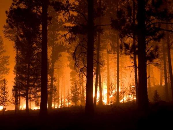
Wildfire season officially starts on April 15 in Washington state. Oregon and Idaho have rolling starts to fire precaution rules depending on local conditions.
Washington’s Department of Natural Resources is sticking to its traditional April 15 start date to enforce summer fire rules on forest and rangelands statewide. Among other things, that means people working in the woods or clearing land need to have fire prevention equipment on hand.
Fire crews across the inland Northwest have already been dispatched to numerous small wildfires this spring.
Public agencies have mostly completed the recruitment of seasonal wildland firefighters and started training. Some private contract wildfire crews may still be hiring, if you’re looking for a tough summer job.