It is not unusual for swarms of small earthquakes to precede a volcanic eruption. They can reach a point of such rapid succession that they create a signal called harmonic tremor that resembles sound made by various types of musical instruments, though at frequencies much lower than humans can hear.
By Vince Stricherz | University of Washington 07/15/2013
Redoubt Volcano’s active lava dome as it appeared on May 8, 2009. The volcano is in the Aleutian Range about 110 miles south-southwest of Anchorage, Alaska.Image-Chris Waythomas, Alaska Volcano Observatory
A new analysis of an eruption sequence at Alaska’s Redoubt Volcano in March 2009 shows that the harmonic tremor glided to substantially higher frequencies and then stopped abruptly just before six of the eruptions, five of them coming in succession.
“The frequency of this tremor is unusually high for a volcano, and it’s not easily explained by many of the accepted theories,” said Alicia Hotovec-Ellis, a University of Washington doctoral student in Earth and space sciences.
Documenting the activity gives clues to a volcano’s pressurization right before an explosion. That could help refine models and allow scientists to better understand what happens during eruptive cycles in volcanoes like Redoubt, she said.
The source of the earthquakes and harmonic tremor isn’t known precisely. Some volcanoes emit sound when magma – a mixture of molten rock, suspended solids and gas bubbles – resonates as it pushes up through thin cracks in the Earth’s crust.
But Hotovec-Ellis believes in this case the earthquakes and harmonic tremor happen as magma is forced through a narrow conduit under great pressure into the heart of the mountain. The thick magma sticks to the rock surface inside the conduit until the pressure is enough to move it higher, where it sticks until the pressure moves it again.
Each of these sudden movements results in a small earthquake, ranging in magnitude from about 0.5 to 1.5, she said. As the pressure builds, the quakes get smaller and happen in such rapid succession that they blend into a continuous harmonic tremor.
“Because there’s less time between each earthquake, there’s not enough time to build up enough pressure for a bigger one,” Hotovec-Ellis said. “After the frequency glides up to a ridiculously high frequency, it pauses and then it explodes.”
She is the lead author of a forthcoming paper in the Journal of Volcanology and Geothermal Research that describes the research. Co-authors are John Vidale of the UW and Stephanie Prejean and Joan Gomberg of the U.S. Geological Survey.
Hotovec-Ellis is a co-author of a second paper, published online July 14 in Nature Geoscience, that introduces a new “frictional faulting” model as a tool to evaluate the tremor mechanism observed at Redoubt in 2009. The lead author of that paper is Ksenia Dmitrieva of Stanford University, and other co-authors are Prejean and Eric Dunham of Stanford.
The pause in the harmonic tremor frequency increase just before the volcanic explosion is the main focus of the Nature Geoscience paper. “We think the pause is when even the earthquakes can’t keep up anymore and the two sides of the fault slide smoothly against each other,” Hotovec-Ellis said.
She documented the rising tremor frequency, starting at about 1 hertz (or cycle per second) and gliding upward to about 30 hertz. In humans, the audible frequency range starts at about 20 hertz, but a person lying on the ground directly above the magma conduit might be able to hear the harmonic tremor when it reaches its highest point (it is not an activity she would advise, since the tremor is closely followed by an explosion).
Scientists at the USGS Alaska Volcano Observatory have dubbed the highest-frequency harmonic tremor at Redoubt Volcano “the screams” because they reach such high pitch compared with a 1-to-5 hertz starting point. Hotovec-Ellis created two recordings of the seismic activity. A 10-second recording covers about 10 minutes of seismic sound and harmonic tremor, sped up 60 times. Aone-minute recording condenses about an hour of activity that includes more than 1,600 small earthquakes that preceded the first explosion with harmonic tremor.
Upward-gliding tremor immediately before a volcanic explosion also has been documented at the Arenal Volcano in Costa Rica and Soufrière Hills volcano on the Caribbean island of Montserrat.
“Redoubt is unique in that it is much clearer that that is what’s going on,” Hotovec-Ellis said. “I think the next step is understanding why the stresses are so high.”
The work was funded in part by the USGS and the National Science Foundation.
Venomous brown recluses exist within a smaller range than many realize, and their existence may be threatened by climate change. CREDIT: Rick Vetter
Wynne Parry, LiveScience Senior Writer
Date: 27 April 2011 Time: 03:24 PM ET
Climate change may give America’s venomous brown recluse spiders a choice: Move to a more northern state or face dramatic losses in range and possible extinction, a new theoretical study suggests.
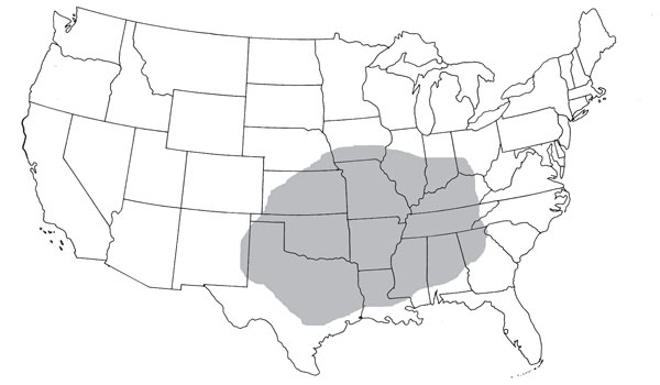
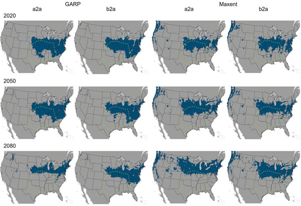
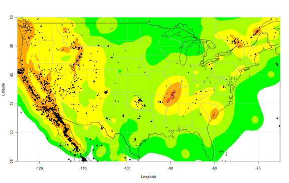
Currently,brown recluse spiders are found in the interior of roughly the southeastern quarter of the continental United States. Researcher Erin Saupe used two ecological computer models to predict the extent of the spider’s range in 2020, 2050 and 2080 given theeffects of global warming.
“The actual amount of suitable habitat of the brown recluse doesn’t change dramatically in the future time slices, but what is changing is where that area is located,” said Saupe, who was pursuing a master’s degree at the University of Kansas when she did the work. She is now a doctoral student there.
If the projections are correct, by 2080, perhaps only 5 percent of the spider’s current range — which extends from Kansas across to Kentucky and from Texas across to Georgia, including the states in between — would remain suitable for it. However, climate change could make portions of Wisconsin, Michigan, Indiana, Ohio, Pennsylvania, New York, Nebraska and South Dakota habitable to the spiders.
The shaded region represents the current distribution of the brown recluse. CREDIT: Erin Saupe/PLoS ONE
Arachnophobia
This may come as a surprise to some residents of these states. In many minds, brown recluse spiders – with their outsized reputation for bringing death, amputations and paralysis – already occupy most of the country, Rick Vetter, a research associate at the University of California, Riverside contends.
Vetter, one of the study authors, created the Brown Recluse Challenge, a 4½-year project. “I got tired of people telling me that brown recluses are all over the U.S and Canada, and I said, ‘Send them to me and I will identify them,'” Vetter said.
One thousand, seven hundred and seventy three spiders later, it was clear that any brown, eight-legged arachnid was at risk of misidentification as a brown recluse – 79 percent of the specimens he received from people across the country were not of the species Loxosceles reclusa, Vetter told LiveScience.
“People fear the unknown. … They like to tell scary stories, they are willing to believe bad things about things they don’t like anyway, so there is a lot of human psychology that is wrapped around the brown recluse,” he said. [Top 10 Phobias]
The challenge has since been picked up by the University of Florida.
In nature, brown recluses live underneath bark or logs in dry areas or underneath hanging rocks. But humans also create a good habitat for them in cellars, attics and garages, according to Vetter.
Their venom contains a toxin that causes skin to die, resulting in what are known as necrotic lesions. In about 90 percent of cases, the bite of a brown recluse has virtually no effect. The other 10 percent cause severe symptoms with potentially life-threatening complications. There are no solid statistics available, but Vetter estimates that one or two bite-induced deaths occur each year, typically in small children.
Homebody spiders
In spite of their affinity for human-created habitats, these spiders have little success establishing and spreading outside their native range. They may be transported when people move outside the spider’s native range, and they can infest a new house, but they won’t spread from there, Vetter said.
“Think about the Dust Bowl era,” he said. “How many thousands of people came to California, how many tens of thousands of boxes of possessions they brought with them, and how many hundreds of thousands of brown recluses came with them? And they didn’t establish a population in California.”
Brown recluses cannot travel on air currents, unlike some other spiders, which limits their means for transport. [How Spiders Fly Hundreds of Miles]
It is possible the spiders may be unable to move north quickly enough to establish in new habitat as parts of their current range become inhospitable, although it is conceivable that by hitching a ride with humans, the spiders may make the migration, the researchers write in a study published online March 25 in the journal PLoS ONE.
The study used two greenhouse gas emissions scenarios, one more dramatic than the other, derived from the Intergovernmental Panel on Climate Change. The two modeling programs took seven environmental variables related to temperature and precipitation into account.
Both of the emissions scenarios indicated new states could be invaded as far north as parts of Minnesota, Michigan and South Dakota. Both scenarios were run using the two ecological models, resulting in divergent trends. One model showed that the spiders’ habitable area would decrease with time, while the other showed an increase in habitable area.
The predictions should not be taken as gospel; the models aren’t perfect. Saupe used them to predict the current range of the brown recluse and found that it included the Atlantic coast states, farther east than where the spiders actually are. The discrepancy may be due to an error in the model, or it may be that spiders are being kept from the habitable territory closer to the coast by a barrier, perhaps the Appalachian Mountains, Saupe said.
“It is scary to think that if this much change could happen in one species, what could happen in the myriad species that exist all over the Earth?” Saupe said.
Two ecological models, named GARP and Maxtent, were used to project the range of the brown recluse, shown in blue, under two different greenhouse gas emissions scenarios: a2a and b2a from the IPCC. A2a assumed more dramatic climate change than b2a. CREDIT: Erin Saupe/PLoS ONE
You can follow LiveSciencesenior writer Wynne Parry on Twitter @Wynne_Parry. Follow LiveScience for the latest in science news and discoveries on Twitter @livescience and onFacebook.
DURHAM, NC – Some blue whales off the coast of California change their behavior when exposed to the sort of underwater sounds used during U.S. military exercises. The whales may alter diving behavior or temporarily avoid important feeding areas, according to new research.
The Southern California Behavioral Response Study exposed tagged blue whales in the California Bight to simulated mid-frequency (3.5-4 kHz) sonar sounds significantly less intense than the military uses.
“Whales clearly respond in some conditions by modifying diving behavior and temporarily avoiding areas where sounds were produced,” said lead author Jeremy Goldbogen of Cascadia Research. “But overall the responses are complex and depend on a number of interacting factors,” including whether the whales were feeding deep, shallow or not at all.
The study, funded by the U.S. Navy Chief of Naval Operations Environmental Readiness Division and the U.S. Office of Naval Research, appears July 3 in the Proceedings of the Royal Society B.
The scientists tagged the whales with non-invasive suction cups, which recorded acoustic data and high-resolution movements as the animals were exposed to the controlled sounds.
“The tag technology we use offers a unique glimpse into the underwater behavior of whales that otherwise would not be possible,” said Ari Friedlaender, a research scientist at the Duke Marine Laboratory.
The scientists found that some of the whales engaged in deep feeding stopped eating and either sped up or moved away from the source of the noise. Not all of the whales responded to the noise, and not all in the same way.
“Blue whales are the largest animals that have ever lived. Populations globally remain at a fraction of their former numbers prior to whaling, and they appear regularly off the southern California coast, where they feed,” said John Calambokidis, one of the project’s lead investigators of Cascadia Research.
That area of the ocean is also the site of military training and testing exercises that involve loud mid-frequency sonar signals. Such sonar exercises have been associated with several unusual strandings of other marine mammal species (typically beaked whales) in the past. Until this study, almost no information was available about whether and how blue whales respond to sonar.
“These are the first direct measurements of individual responses for any baleen whale species to these kinds of mid-frequency sonar signals,” said Brandon Southall, SOCAL-BRS chief scientist from SEA, Inc., and an adjunct researcher at both Duke and the University of California Santa Cruz. “These findings help us understand risks to these animals from human sound and inform timely conservation and management decisions.”
A related paper published July 3 by the same research team in Biology Letters has shown clear and even stronger responses of Cuvierâs beaked whales to simulated mid-frequency sonar exposures. Beaked whales showed a variety of responses to both real, military sonar in the distance and nearby simulated sonar. What the beaked whales were doing at the time appeared to be a key factor affecting their reactions.
Earthquakes equal to or bigger than magnitude 3.0 in the United States between 2009 and 2012. The background colors indicating earthquake risk are from the U.S. National Seismic Hazard Map. CREDIT: Science/AAAS
By Becky Oskin, Staff Writer
July 11, 2013
Two new studies of earthquakes near injection wells have seismologists using words rarely heard these days in earthquake science: prediction and warning.
The research has also renewed calls for better seismic monitoring and reporting in regions experiencing man-made earthquakes.
“Shale gas operations have completely changed our energy policy and people are injecting in places they’ve never injected before. If we’re going to do this safely, we need to address the environmental issues, including protecting water supplies and earthquake risk,” said Cliff Frohlich, a seismologist at the University of Texas Institute for Geophysics who was not involved in the new studies.
The two reports appear in today’s (July 11) issue of the journal Science.
Links between injection and earthquakes
In the Midwest, researchers discovered a warning signal that moderate-sized earthquakes may strike near injection wells, where mining companies dispose of waste fluids. At three sites in Oklahoma, Colorado and Texas, passing seismic waves from faraway earthquakes — the recent massive temblors in Japan, Sumatra and Chile — triggered swarms of small earthquakes. The seismic activity continued until magnitude-4 and magnitude-5 earthquakes struck, such as the large earthquakes near Prague, Okla., in November 2011. [7 Craziest Ways Japan’s Earthquake Affected Earth]
“We’ve been telling our operators for some time that this is one of the warning signs to look for,” said Austin Holland, a seismologist with the Oklahoma Geological Survey who was not involved in the study. “If you see remote triggering of your wells, it’s a clear indication that your faults are right at the failure point. It just took a little tickle, if you will, to trigger the earthquakes.”
In a separate study, researchers documented a clear link between earthquakes and production, or removing and injecting underground fluid, at Southern California’s Salton Sea Geothermal Field power plant. Every 500 million gallons of water pumped out of the ground caused one detectable earthquake per 11 days, according to the report.
“The thing that best predicted the earthquake rate was the net amount of water extracted from the ground,” said Emily Brodsky, lead study author and a seismologist at the University of California, Santa Cruz.
Scientists have long known that geothermal projects can trigger earthquakes, but some communities are wary of the seismic risk. Construction on a geothermal energy plant in Basel, Switzerland, was shut down in 2009 after fluid injection triggered earthquakes up to magnitude 3.4. Brodsky’s study offers a new statistical model for predicting how many earthquakes to expect at a geothermal plant, based on the amount of fluid going in and out of the ground.
“This paper has made a very direct and compelling correlation between the net of fluid out and fluid in and the rate at which these small earthquakes are happening,” said William Ellsworth, a seismologist at the U.S. Geological Survey’s Earthquake Science Center, who was not involved in the study. “This seems like a very promising way of applying this particular statistical model.”
Remotely triggered warnings
Many scientists also suspect a link between mining-related wastewater injection wells and a barrage of earthquakes in the central and eastern United States in the past decade. The surge outpaced natural background trends starting in 2001, according to a review by Ellsworth also published today in Science. But proving a cause-and-effect has been difficult for researchers, who lack the evidence for a slam-dunk case. Outside of California, there are few dense seismic networks to precisely locate small earthquakes, and injection well data is not immediately available.
Discovering earthquake warning signals in the Midwest, before the larger, more damaging temblors, was possible only through a temporary, massive seismic monitoring network called the USArray. The explosion in shale gas exploration also helped, because remote triggering is most common in places with high fluid pressure, such as geothermal fields, hot springs and the estimated 100,000 injection wells in the United States. [Top 10 Alternative Energy Bets]
A quick reminder: Fracking itself doesn’t cause felt earthquakes. Injecting fluids into the ground (as happens with the wastewater from fracking) spawns man-made earthquakes. The added fluids increase pore pressure on a fault’s surface, unclamping the fault and making it easier to slip.
“The fluids are weakening the fault,” said Nicholas van der Elst, a seismologist at Columbia University’s Lamont Doherty Earth Observatory in New York and lead author of the remote-triggering study. More than 50 years of controlled and unintentional experiments have proved the link.
But even with a better seismic network, remotely triggered earthquakes are of limited use as warning signals. First, not all regions with possible man-made earthquakes also had remotely triggered earthquake swarms. Second, only one earthquake every year, on average, is big enough to send seismic waves rippling across Earth’s surface.
“The trouble with using this for forecasting is that the huge earthquakes that are triggering earthquakes are extremely rare,” Frohlich said. “We’ve had three in the last few years, but that’s an unusual rate. In the last 50 years, we’ve only had maybe a dozen earthquakes that big.”
The three sites with earthquake “sirens” were Prague, Okla., Synder, Tex., and Trinidad, Colo. Each saw a spike in seismic activity near injection wells within 24 hours of huge earthquakes in Chile in 2010, Japan in 2011 or Sumatra in 2012. The number of quakes increased until a magnitude-4 or magnitude-5 earthquake hit, includingOklahoma’s strongest recorded earthquake.
“I think this [study] shows that fluid pressure is really driving these earthquakes,” Van der Elst said. “Stress has been increased by the injection of all this fluid in these regions where people have suggested a connection between wells and earthquakes.
“The big implication in this is that remote triggering could act as a stress probe. You could look for remote triggering to anticipate large induced earthquakes,” Van der Elst said.
Better seismic monitoring needed
But well operators are already aware that upticks in seismicity near their injection sites are a warning sign that a larger quake could strike, Holland said. Some companies operate their own seismic networks to monitor wells, he added. “The idea of controlling your injection parameters based on the seismicity you’re observing has been around for 30 or 40 years,” he said.
In his Science review, Ellsworth recommends seismic monitoring of wells to improve understanding of man-made earthquakes and help regulators set seismic activity thresholds that limit injection if there are too many small quakes.
“We need better seismic monitoring so we can see the small earthquakes, and I would also like to have more information about the actual disposal process,” Ellsworth said. “Right now, all that’s required is monthly reporting, and that’s not adequate to build geophysical and geological models of the [earthquake] process.” Regulators developing new laws and reporting requirements also need much more timely and better information, Ellsworth said.
In response to Oklahoma’s recent uptick in earthquakes, the Oklahoma Geological Survey is doubling and modernizing its seismic monitoring network, Holland said.
Bolivian President Evo Morales thanked the Organization of American States (OAS) member countries this Wednesday for the severe criticisms they leveled at the governments of four European countries, PULSAR reported.
Last week, France, Portugal, Italy and Spain closed their airspaces to Morales’ presidential plane, giving rise to a serious diplomatic incident.
The Bolivian leader welcomed the OAS resolution and stressed that such a show of support entailed not only “defending Evo Morales, but the people of Latin America and the Caribbean as well.”
On Tuesday, the OAS condemned the mistreatment of Morales by the governments of several European countries. The international association called the actions of these countries a “clear violation of the basic norms and principles of international law, such as the inviolability of Heads of State.”
Referring to the mistreatment he experienced days ago when his plane was denied permission to cross the airspace of these countries and was forced to land in Vienna, Austria, Morales stated he could not “conceive that some European countries insist on causing us harm.”
“It seems some countries in Europe continue to think as they did 500 years ago,” Morales charged.
The indigenous Bolivian leader underscored that Latin American peoples are ready to confront “these types of impositions and decisions that do so much damage to human rights.”
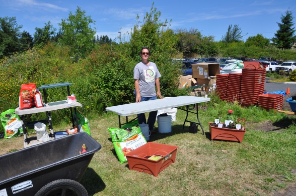
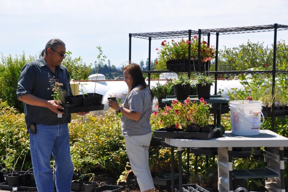
Didi Garlow, Master Gardener at the Diabetes Garden helps fill planters to take home. Photo by Monica Brown
By Monica Brown, Tulalip News Writer
TULALIP, WA – The Diabetes Garden at the Karen I Fryberg Health clinic gave away, to their attendees, planter boxes with plants. The Diabetes Garden is a place where patients and community members can come to learn more about plant and garden care for a healthier future.
Community members and patients were invited to come out and fill a planter box to bring home so they can start a small garden. The planter boxes were filled with an assortment of vegetable, herb and flower plants and each person was given a fresh bag of soil to bring home.
This garden event will run until 1:00 pm Tuesday, July 16. But will continue during future, to be announced, garden and health clinic events.
Master Gardener, Roni Leahy on right, sorts out plants to take home Photo by Monica BrownPlanter boxes, plants and soil were given to each person. Photo by Monica Brown
In the early 1990s, James Childers attended the groundbreaking of the Redbird Smith Health Clinic in Sallisaw, Okla., five miles north of the little town where he lived. Redbird Smith was the first clinic built from the ground up by the Cherokee Nation and—Childers was surprised to see—it was a huge improvement over the typical Indian clinics he was used to.
As an architect, Childers had been doing healthcare projects primarily with the Sisters of Mercy system since 1980. He’d never pursued any government- or publically funded healthcare projects—but the Redbird Smith project got him thinking.
“The architect for that clinic was out of New Mexico,” Childers says. “And that’s what caught my attention. I thought, there’s no need for them to be going to Albuquerque to do clinics in Oklahoma.”
The building, staffing, and maintenance of healthcare facilities for federally recognized Native American tribes have fallen under the jurisdiction of Indian Health Service (IHS) since that department was established in 1955. Traditionally, these IHS clinics haven’t exactly been design-driven, nor have they been particularly reflective of the cultures they serve. Built to meet strict federal guidelines that could be easily replicated from site to site, most of these clinics “were just boxes,” Childers says. “They’re just very functional government buildings.”
Over the past two decades, however, tribes have begun investing more and more money earned through their businesses in improving healthcare for its members. Fueled by joint ventures between the tribes and IHS, healthcare facilities are getting the attention they deserve, with bigger footprints (to better serve the number of patients and house more varied services); thoughtful innovations based on wellness research; and culturally significant touches to celebrate the rich histories of the tribes and provide a positive community resource.
Since 1992, Childers (a member of the Cherokee Nation himself) has been a prolific contributor to these new facilities. Of the 19 joint venture projects between IHS and tribes across the country, Childers has designed seven of them—all publicly bid and awarded separately by each tribe.
Healthcare Design spoke with Childers about the legacy he’s building, as well as the process behind designing facilities that proudly demonstrate the tribal values and cultural wealth of a historically underserved population.
Healthcare Design: Your first tribal project was the Wilma P. Mankiller Clinic in Stilwell, Okla., in 1992. How did you approach that job? James Childers: That was an Indian Health Service facility. And as we went through the IHS program, we figured out that what it produced was the typical Indian clinic you might walk into anywhere: too small, overcrowded, no waiting room, no people amenities. Indian Health Service did a fantastic job of getting the most out of its square footage, but there were really no provisions for waiting areas.
We’re in a very rural area here in Oklahoma; these people might drive 40-50 miles for healthcare. And when they did, they brought Grandpa and Grandma and the kids. Everybody came. As a result, you’d go into these clinics and the corridors would just be lined with people.
The IHS design guidelines dictated that you be within 10 percent of their square footage limitations. So what we ended up doing was reducing the square footage in the mechanical rooms. By selecting the right kind of systems and putting a lot of this equipment on the roof instead of on the floor, I ended up under their program on total square footage.
So what they allowed me to do—after many meetings and discussions—was to take that additional square footage and put it into circulation. We increased the widths of corridors and increased the size of waiting rooms. This was all an effort to get Indian healthcare environments compatible with private care.
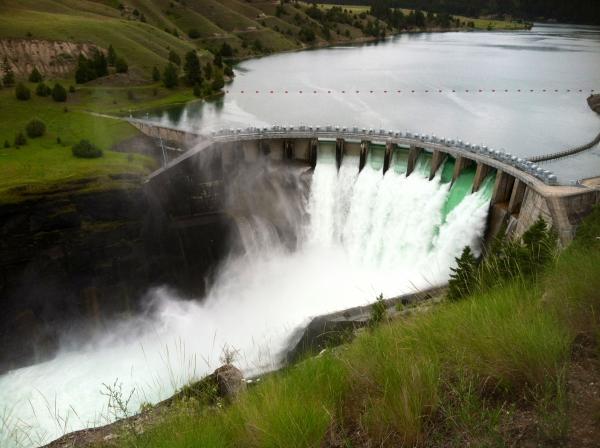
The Confederated Salish and Kootenai Tribes in Montana stand to become the first tribes in the country to own a major hydroelectric dam. In Colorado, tribes are managing parts of hydro projects. All are examples of tribes regaining control of resources on their land. Aspen Public Radio’s Marci Krivonen reports.
Credit Marci Krivonen The Kerr Dam in Northwest Montana was built in the 1930’s on the Flathead Indian Reservation. It’s been owned by non-tribal companies since it was built.
In Colorado’s southwest, the Ute Mountain Ute tribe co-manages part of the Dolores Water Project. And, near Durango, the Animas/La Plata project is partially managed by the state’s two tribes. Ernest House directs the Colorado Commission of Indian Affairs.
“Not only do these water projects strengthen tribal sovereignty, but they also solidify a treaty obligation to the Utes here in Colorado. I think that by the tribe’s involvement in a lot of these projects, it provides a very important tool for future economic development, especially, specifically, water,” he says.
While the project is different, the goals are similar in Montana. When the tribes take over the dam there, they say, their sovereignty will be strengthened.
Jordan Thompson of Energy Keepers Inc. stands high above the Kerr Dam outside of Polson, Montana. The tribes in this area are preparing to take over the hydro project in 2015.
The massive Kerr Dam in Montana is near snowcapped mountains, close to ancient buffalo hunting grounds. Emerald green water violently sloshes over the lip of the dam and into the Flathead River. To say the area’s beautiful, is an understatement.
A 19th century treaty created the Flathead Indian Reservation, and later, white settlement brought agriculture. The massive dam was built on tribal land by a local power company in the 1930’s to quench the thirst of newly planted farms.
“This is a place of great spiritual significance for the tribes, and so when the dam was being built, they really resisted, they were trying to not have that dam built,” says Jordan Thompson.
Thompson’s with the tribally-run company that’s preparing to take over ownership of the dam. Despite tribal protests in the 30’s the dam was built and has been producing electricity ever since..
“There were just a bunch of people who built it, over 1200 people at one point. Ten tribal members were killed during the construction of it. It was built because the tribes were just powerless to do anything to stop it,” Thompson says.
Over the years, the dam supplied millions of dollars worth of power. The tribes received a small portion, as rent. Fish habitats were damaged, as the dam continued to generate electricity.
Now, the dam is about to change hands. A treaty signed in 1985 transfers ownership of the dam to the Salish and Kootenai.
“This is significant because it’s an assertion of the tribes sovereignty over the resources they’ve used for their entire existence,” says Sarah Bates with the University of Montana.
She studies water, natural resources and tribal lands. She says what the Salish and Kootenai are doing is a model for other tribes in the U.S.
“It’s happening around the country, this is something that tribes have the capacity to step up and play not just a stakeholder role, but actually an owner and management role. When they aren’t just participants in a process, but actually gain authority over those facilities, that’s a major step forward in asserting and realizing their sovereignty.”
Tribes in Oregon and New York state are now attempting to gain control of hydroelectric projects.
The 1000 foot boardwalk takes you to an overlook of the Kerr Dam, which stretches 540 feet across and 200 feet high.
The Kerr Dam is run by the company PPL Montana and the tribes are still negotiating the purchase price. PPL Montana values the dam at about $51 million, while the tribes say the number is closer to $16 million. Once the issue is resolved, tribal members plan to take over the dam in September of 2015.
This story is the result of an environmental fellowship put on by the Institutes for Journalism and Natural Resources.
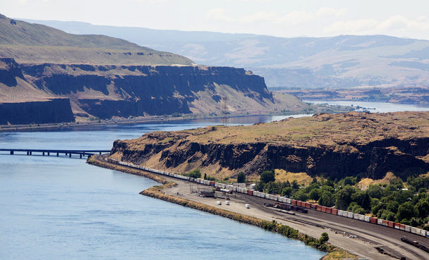
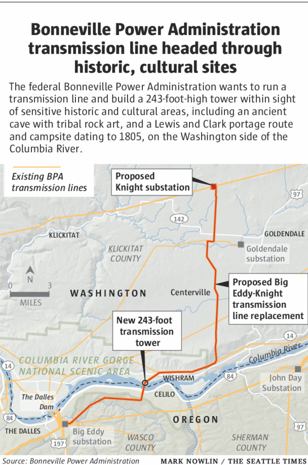
A Bonneville Power Administration transmission-tower construction project has been on hold for more than a year as a landowner tries to defend ancient Indian archaeological sites and stops on the Lewis and Clark Trail.
The BPA wants to finish a project near an ancient-village site on land that runs past this bridge and around the bend on the Columbia River. STEVE RINGMAN / THE SEATTLE TIMES
WISHRAM, Klickitat County —
All he was looking for was a little retirement property. But Robert Zornes, a Forks RV-park owner, wound up with quite a lot more.
“I kept seeing this property, 122 acres on more than a mile of the Columbia River for a quarter-million dollars, then it’s lowered to $100,000. And I am thinking, ‘This has to be a practical joke,’ ” Zornes said. So he bought it, right off a real-estate website, without ever talking to the property owner.
Then came the big surprise: He had purchased one of the most historically and archaeologically sensitive pieces of property in the state.
Home to a campsite and portage route on the Lewis and Clark Trail. A cave, with prehistoric Indian rock art. Indian burials, petroglyphs and story stones. And some of the last upland vestiges of an important Indian village near Celilo Falls, once one of the greatest Indian salmon fisheries, gathering grounds and trading areas in North America.
“I wanted a pig, a horse and a cow, or maybe a dog,” Zornes said. “I wasn’t looking for a historical property. I just wanted some place to retire.”
But since he purchased the property in 2011, Zornes often can be found in what he calls his war room: a study in his double-wide by the river, packed with historic photos and books — and documents from two years of frustrating correspondence with the Bonneville Power Administration.
The federal agency — which sells power from the dams on the Columbia and Lower Snake rivers — is in the middle of construction of a 28-mile, more than $200 million transmission line. Construction started right about when Zornes bought the property — and he soon received a letter from the agency informing him the BPA was about to cross the river and replace a tower near the cave. The new tower would be taller, wider and require blasting to construct — which he feared would destroy the cave and its ancient art.
And Zornes, as it turns out, is a history buff. As he put two and two together, he came to understand just how special the landscape he had purchased was. “BPA starts talking about a bulldozer and we kind of freaked out.”
BPA informed him in a 2012 letter that if he didn’t grant access across his property, the agency would dynamite an alternative access road, doing potentially more damage. The fight was on.
Zornes denied access across the easement on his property, saying it was granted to a different federal agency for another purpose, and since expired. He filed trespass claims. He invited the Yakama Indian Nation to revisit sacred lands on his property. He cold-called the lead preservation officer for the Lewis and Clark National Historic Trail in Omaha and invited him to come have a look.
Zornes’ efforts so far have helped shut down construction of the project on his property at a cost of $2 million and counting. The agency contends its easement is valid, and that it can and will proceed with the project. Zornes is just as adamant in his opposition.
“You think the government is your friend,” Zornes said. “But they are more like the kid that beat you up for your lunch money.
“I’m not a senator, I am not a congressman. Here we are, two uneducated, lower- middle-class people in Forks,” he said, speaking of himself and his wife. “We have held them up more than a year. I think that’s significant.”
Bonneville officials say the agency has wanted to listen to all sides to reach agreements in the dispute, and stopped construction in order to do so.
“It’s a sensitive site, and we are trying to be extra careful,” said Lorri Bodi, BPA’s vice president for environment, fish and wildlife. She acknowledged there have been “bumps in the road.”
“We have discovered additional things, and certainly we have made some mistakes along the way,” she said. Those include a BPA contractor mistakenly bulldozing and destroying a prehistoric relic documented as a burial cairn on Yakama lands, despite promises to protect it.
Bodi contended the agency has made up for those mistakes and is working hard to minimize the damage by the project.
Preservation concerns
State records show a continuing pattern of frustration in getting the right answers from Bonneville, or any at all.
When the contractor bulldozed the cairn, the agency did not seem to appreciate the seriousness of the matter, state assistant attorney general Sandra Adix wrote Bonneville last summer.
Repeated attempts by the state Department of Archaeology and Historic Preservation to gain specific information about the agency’s construction and its ongoing and potential effect on archaeological resources “seem to have fallen into a black hole,” Adix wrote in other correspondence.
The agency also has not included the National Lewis and Clark Historic Trail as a full partner in the consultation process, said Dan Wiley, chief of stewardship. “We have gotten short shrift and have continuously tried to bring to the table the recognition that this a unique site, a special site, and it deserves protection from further negative impacts.
“I don’t know if it is too late or not. That is really up to BPA and whether or not they have real concern about cultural resources, and protection of cultural resources.”
Wiley would like to see the transmission line located miles to the east. As planned, it will be in view from Columbia Hills State Park, with its petroglyphs, as well as the Lewis and Clark Historic Trail, and from across the river at the Confluence Project art installation planned at Celilo Village by internationally known artist Maya Lin.
It also will further clutter views of the Columbia River Gorge, but BPA already has obtained a promise from the Friends of the Columbia River Gorge not to sue in return for a payment of $1.8 million. The BPA also in December paid a more than $2 million settlement to the Yakama Indian Nation to allow the project to continue despite impacts to its culturally sensitive lands.
Conflict still unsolved
At Bonneville, there’s not at present a willingness to consider another alignment, top officials say. Because there is already a utility line across the river, landing on a tower dating to the 1950s near the cave. That alignment, chosen through a lengthy public review process as part of an environmental-impact statement, is preferred by BPA.
“It’s much like repaving an old highway; are you better off moving it, or leaving in the same place?” said Larry Bekkedahl, senior vice president for transmission services at BPA. “In this case we have chosen using the existing line, because it had lesser impacts than trying to find other routes that would move the line on both sides and have a new river crossing, as well as time delays. So the bottom line is we would reuse the existing line and not relocate it to another location.”
But what Bonneville has in mind is nothing like the impact of what is already there today, historic preservationists say.
“This is not just repaving,” said Allyson Brooks, Washington’s State Historic Preservation Officer. “It is the equivalent of taking a two-lane road and making it a superhighway. It is not the same thing. Maybe in essence, but in size and impact, it is greater.
“One of the reasons these are public processes is so people get to say what the impact is, it is not a unilateral decision. That is democracy.”
Bonneville has committed to moving the tower 20 feet farther north of the cave with its prehistoric rock art. But it will be a bigger, higher tower — 243 feet tall, compared with the 190-foot-tall tower near the cave today, with 22 lines instead of three. The new tower also has a much larger and taller footing, and requires controlled blasting to set it in the basalt cliffs above the river.
BPA assures the blasting won’t destroy the cave. But that’s still under review — and the agency’s credibility has been dented by historic sites and archaeology overlooked and even destroyed as construction got under way.
“We are still working on damage assessment for the cairn, and the impacts for the Lewis and Clark Trail are unresolved,” Brooks said. “If we could lessen the direct and visual impacts, we would certainly prefer that happening. It’s been difficult. It feels rushed, and in the rush the time hasn’t been taken to really balance things the way they should be balanced.”
To Zornes, the fact that one transmission line is there today doesn’t justify building another, it argues for backing off a place that already has been altered by industrialization. First came the railroad. Then the inundation of Celilo Falls to build the Dalles Dam in 1957. Then the transmission towers built that exist today — to be superseded now by even larger towers, with more lines.
“Our preference is no new towers,” Zornes said. “Two wrongs don’t make a right. The first tower should not have ever been placed on this historic and culturally rich and highly scenic bluff.”
Bonneville has since written Wiley to state the agency doesn’t believe the trail merits listing on the National Register of Historic Places, which would afford it more protection — a decision blasted by Washington’s Department of Archaeology and Historic Preservation, the National Park Service, and Johnson Meninick, Yakama Indian Nation cultural resources program manager.
The conflict remains unresolved.
“What is left is intact”
Wiley said it wasn’t until he came here in person that he understood just how significant this place is.
“You can only see so much from your desktop,” he said.
Once on the site, he walked the same sands that bedeviled Lewis and Clark and the Corps of Discovery as they portaged around the roaring falls at Celilo, one of the greatest fisheries in the aboriginal world.
Just above on the cliffs is the very spot where William Clark likely stood to draw the famous Codex H map of what he called “the Great Falls of the Columbia” — Celilo Falls, with Indian lodges and fish-drying racks along the banks.
“It is a highly significant location for the two cultures of the Pacific Northwest and their intersection,” Wiley said. “What is left is intact. The palisades that are above the water are described in the journals. The walkway that Lewis and Clark took on the north bank, that is pretty much intact, and there is no other place on the planet that the events of Oct. 22 and 23 and 24, 1805, could have taken place.”
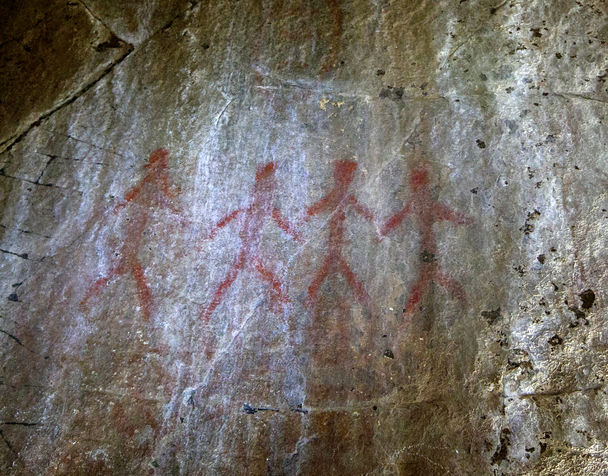
Just above Lewis and Clark’s portage route is the cave, used for tribal vision quests and other religious and spiritual rites for centuries untold. Inside, the light is soft, and drawn figures with outstretched arms keep an enigmatic vigil on the cool rock walls.
Through its narrow opening, the cave looks to a view not seen in all the centuries people have stood here: the transmission towers Bonne- ville already has built in its chosen alignment, just across the river.
STEVE RINGMAN / THE SEATTLE TIMES Prehistoric Indian art on a cave on Robert Zornes’ property.
Lynda V. Mapes: 206-464-2736 or lmapes@seattletimes.com
THE HILL
A high-profile lawsuit on the voting rights of Native Americans could help determine control of the Senate in the next Congress.
A group of 16 Native Americans, nine of whom are military veterans, is waging a protracted legal battle against Montana’s Democratic secretary of State and county administrators, arguing for improved access to voter registration sites.
The case will be significant for Democrats in 2014 as they vie to keep control of the upper chamber by holding retiring Sen. Max Baucus’s (D-Mont.) seat. Republicans need to pick up six seats to win back control of the Senate.
The litigation is moving forward at the same time as a recent Supreme Court decision that no longer requires a number of jurisdictions to get advance federal permission in order to make changes to their election laws.
The three Montana counties now being sued have historically lost Section 2 Voting Rights Act cases. However, for the state’s overwhelmingly poor and geographically isolated Native Americans — who vote predominantly for Democrats — the Montana fight is deeply personal. Tribal leaders say it is an issue of fundamental fairness.
Image from Think Progress
An estimated 50,000 Native Americans are eligible to vote in Montana. Many of them live on reservations throughout the sprawling 550-mile-wide state, which means driving more than 100 miles for some to reach polling sites established long before Native Americans got the right to vote.
It’s the distance equivalent of voters in Washington, D.C., having to drive to Gettysburg, Pa. and back to complete their late registration forms or cast early in-person absentee ballots.
If the state allowed more voting stations, known as satellite offices, on reservations, more Native Americans would have the ability to vote by a factor of 250 percent, a group supporting the lawsuit argues.
This group, which is providing strategic and financial support to the plaintiffs, includes Four Directions, a nationally known voting rights organization, and Tom Rodgers, the Native American lobbyist who blew the whistle on former lobbyist Jack Abramoff for charging Native American tribes exorbitant fees on lobbying.
The Department of Justice, Montana tribal leaders, the ACLU and the National Congress of American Indians have all backed the plaintiffs in the legal dispute.
The origin of the lawsuit began when Rodgers, a member of Montana’s Blackfeet tribe, received a phone call that U.S. Army Spc. Antonio Burnside, a fellow Blackfeet member whose tribal name was Many Hides, was killed last year in combat on Good Friday in Afghanistan.
In late April 2012, after raising the money to help celebrate the soldier’s life, Rodgers said a feeling of rage overcame him.
He noted that Native Americans have the highest percentage of military enlistees of any ethnic group.
“Some of the poorest of the poor can fight a war and die for you on a hellish moonscaped mountainside and then when they return home in a flag-draped coffin, you seek to diminish their native brothers’ and sisters’ ability to vote. Young dead soldiers do not speak. They leave us their deaths. It is us who must give them meaning by remembering them,” Rodgers said. “We got tired of the dark lies in rooms of white marble. Now the plaintiff warriors will take their faith in justice by acting with justice to other rooms of white marble: the 9th Circuit Court of Appeals and Congress.”
Sen. Jon Tester (D-Mont.), who won reelection last year, said that poverty and unemployment levels on reservations are higher than in the rest of the state, and that many Native Americans don’t have access to transportation or can’t take time off from work.
“Native Americans are about 6 percent of the population, so it’s absolutely significant,” said Tester.
“Everybody who’s entitled to vote, we ought to give them every opportunity to vote,” Tester said. “We shouldn’t be limiting participation, we should be encouraging it.”
The suit might have an impact beyond Montana as well. If it goes as far as the Supreme Court, major Native American populations in Arizona, New Mexico, North Dakota, South Dakota, Nevada, California, Minnesota, Washington, Oregon and Alaska could see their voting rights greatly expanded or restricted.
Democrats are facing challenging elections in four of those states next year.
Native Americans have played a crucial role in electing Democratic senators, including Tester and Sens. Tim Johnson (S.D.), Maria Cantwell (Wash.), Al Franken (Minn.), Heidi Heitkamp (N.D.) and Mark Begich (Alaska.). All have won elections by fewer than 4,000 votes.
But for now, Montana — where Democrats are scrambling to find a candidate following ex-Gov. Brian Schweitzer’s surprise decision not to run — is the central battleground.
Montana Secretary of State Linda McCulloch (D) says she supports the Native Americans’ demands, but that the lawsuit is misdirected.
At a video-recorded meeting with the tribes earlier this year, tensions between the two sides were palpable as they failed to negotiate a compromise after a nearly hour-long discussion.
“I care that the people at this table have equal access, and what is in my power as secretary of State to do, I can do,” said McCulloch. “What I do not have the authority over is establishing county clerk offices. That authority belongs to the county governing body, the county commissioners.
“We will support and assist any county whose governing body has made a decision to open a second county clerk election office that can offer services such as registering voters and issuing absentee ballots. You have my unwavering commitment to that.”
A spokeswoman for McCulloch, citing the ongoing litigation, declined to comment for this article.
The plaintiffs and tribal leaders rejected McCulloch’s remarks. They said Montana’s secretary of State should join the tribes by officially standing with the plaintiffs and leading the county commissioners to create the satellite offices.
J. Gerry Hebert, who worked on voting rights issues for more than 20 years in the Department of Justice’s Civil Rights Division, doesn’t agree with McCulloch’s assessment either, saying that this type of case falls directly within her office’s jurisdiction.
“The secretary of State is the chief election officer and as such has the overall responsibility to ensure that all the state laws are complied with,” said Hebert, now the executive director of the Campaign Legal Center. “And in this case, which is typically the case, a plaintiff will file a lawsuit and bring it against both local and state election officials, because it is both of their responsibilities.”
Although the issue has been in the local press for nearly a year, the Montana Democratic Party has not weighed in on the lawsuit, saying only that it supports greater access to polling sites and will continue aggressive “get out the vote” efforts.
“Increasing access to the ballot box on reservations and throughout Montana has always been a priority,” said Chris Saeger, a spokesman for the state’s party. “We would welcome any improvements that make it easier for Montanans to have their say in elections.”
“The Democratic Party of Montana has said we have done what we could,” Rodgers said. “But hope has two beautiful daughters. Their names are anger, for the way things are, and courage, to make a difference.”
Carole Goldberg, a professor and vice chancellor at UCLA’s School of Law who has dealt extensively with Native American legal rights, said discrimination is widespread in many states with Native populations.
“There are persistent patterns where states have criminal jurisdiction on reservations and the counties that exercise this jurisdiction locate their facilities and services in a place convenient for the non-Native population and not the Native populations,” said Goldberg, who has donated to multiple Democratic candidates.
Barring a settlement, oral arguments are expected to begin this fall.


 The federal agency — which sells power from the dams on the Columbia and Lower Snake rivers — is in the middle of construction of a 28-mile, more than $200 million transmission line. Construction started right about when Zornes bought the property — and he soon received a letter from the agency informing him the BPA was about to cross the river and replace a tower near the cave. The new tower would be taller, wider and require blasting to construct — which he feared would destroy the cave and its ancient art.
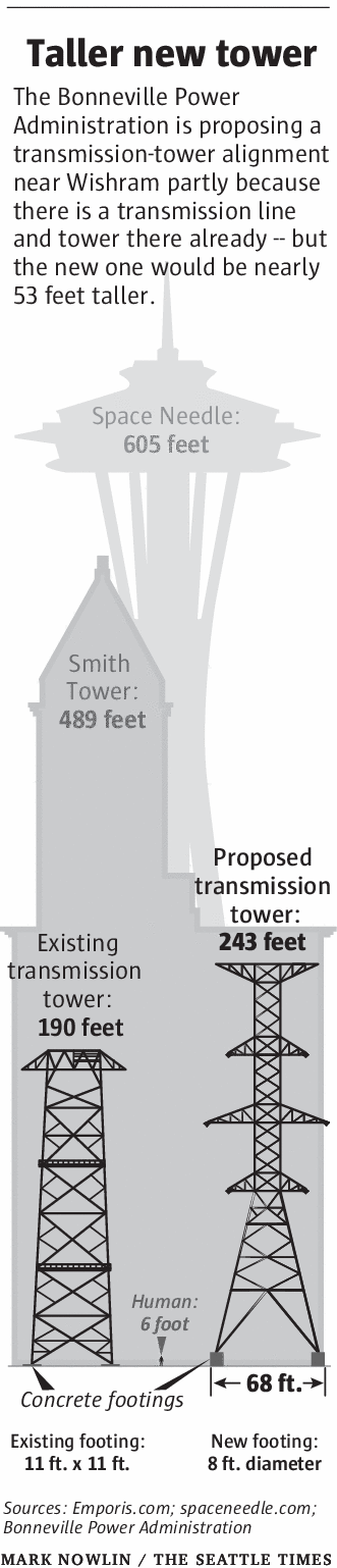 Bonneville has committed to moving the tower 20 feet farther north of the cave with its prehistoric rock art. But it will be a bigger, higher tower — 243 feet tall, compared with the 190-foot-tall tower near the cave today, with 22 lines instead of three. The new tower also has a much larger and taller footing, and requires controlled blasting to set it in the basalt cliffs above the river.